Here comes the heavy rain in Jharkhand

Source: telegraphindia.com

Several parts of the state, especially those in its southern, central and western regions, are expected to experience heavy to very heavy rainfall in the next 24 hours, courtesy a depression over the Bay of Bengal.

Both the Ranchi and Calcutta centres of the India Meteorological Department (IMD) on Tuesday issued downpour alerts in their bulletins.

“The low-pressure area that was hovering over the north Bay of Bengal has intensified into a depression and lay centred around 160km southeast of Balasore (Odisha) and about 130km south-east of Digha (Bengal). Under its influence, several parts of Jharkhand will get heavy rainfall in the next 24 hours,” said R.S. Sharma, a senior Met scientist at the IMD’s Ranchi centre.

He said the depression would intensify into a deep depression as it moved north-westwards across Odisha and Bengal coasts over the next 48 hours.

“We believe the depression will result in heavy to very heavy rainfall in several places across the state in the next 24 hours,” he added.

The monsoon trough was on Tuesday passing through Ganganagar, Hissar, Mainpuri, Mirzapur, Ranchi, Jamshedpur and northwest Bay of Bengal, extending up to 1.5km above mean sea level.

Weathermen in Calcutta also predicted heavy and widespread rainfall.

“The depression is expected to weaken only after the next 48 hours,” said a duty officer, adding that several districts of Jharkhand were expected to experience a good spell of showers.

The showers during the next two days would help in reducing the monsoon deficit, which on Tuesday was at 40 per cent. Met data show that the state has received 352.5mm of rainfall so far against an average normal of 587.5mm.

The depression build-up coupled with an active monsoon trough gifted Jamshedpur a rainy Tuesday.

Weathermen said around 50 per cent Met stations in southern and central Jharkhand reported showers on Tuesday.

At some places the rainfall was accompanied by winds at 15kmph.

The local Met observatory in Jamshedpur recorded around 20mm of rain while several places in Ranchi and its outskirts recorded rainfall of around 5mm from 8.30am on Monday to 8.30am on Tuesday. Simdega recorded 70mm while Dhanbad experienced 40mm of rain. Palamau district headquarters Daltonganj recorded 30mm of rain while Chakradharpur, Chaibasa (both in West Singhbhum), Ramgarh, Chandil (in Seraikela-Kharsawan) and Ghatshila (in East Singhbhum) witnessed 10mm of rain each.

Heavy Rainfall in Bihar; Rivers Pose Flood Threat to Many Districts

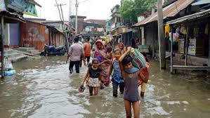
Source: weather.com

Ever since the monsoon swept the Bihar on June 22, the state has witnessed good rainfall. Bihar has received 333 mm of rainfall this season from June 1 to July 12— 9% more than normal for this time of the year. On Friday, the monsoon fury continued as many parts of the state were lashed with very heavy rainfall and thunderstorm.

The downpour is triggered by the monsoon trough—an extended region of low atmospheric pressure— that persists from east to west of Indo-Gangetic plain. This well-marked low-pressure has moved northwards since Thursday and a branch of it runs from northwest Bihar to northeast Bay of Bengal across Jharkhand and Gangetic West Bengal causing widespread rainfall throughout the region.

The Weather Channel met team has forecast the surface low-pressure to persist for the next 5 days leading to very heavy rain and thunderstorms across the region. The India Meteorological Department (IMD) has forecast heavy to very heavy rains with extremely heavy falls at isolated places across Bihar. The very heavy rainfall is very likely to continue in the state till Monday.

Water levels in all major rivers of north Bihar are rising due to the incessant rainfall in Bihar and Nepal. The Times of India reported that the river Gandak poses a flood threat to Muzzafarnagar and Champaran. The sorrow of Bihar, Kosi river, as well as other rivers like Karcha and Bagmati, are also likely to swell due to heavy rains. The authorities have been monitoring the situation.

The 24-hour rainfall accumulation in Patna till Friday morning was 25 mm. The temperatures in the city stayed 2°C below normal between 25°C and 31°C. Generally cloudy sky with intermittent rain is forecast in Patna till next Tuesday. More rains are likely to follow in the next week. The 24-hour rainfall was very high at 152 mm in Farbesgang and 130 mm Chapra.

Moderate to heavy rainfall in past 24 hours in Bihar

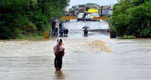
Source: newsonair.com

In Bihar, moderate to heavy rainfall occurred in western and eastern parts of the state in past 24 hours. 

Due to incessant rainfall in the catchment area of Nepal originating rivers for the last four days, Gandak, Bagmati and Budhi Gandak and their tributaries are swollen. 

Evacuation drive has been started in West Champaran from low-lying and riverine area of Gandak to shift people to safer places. 

East Champaran and Muzaffarpur. Traffic has been disrupted due to water-logging of Bagmati and Lalbakeya river on Sheohar-Motihari road. 

Extra vigil is being maintained on barrages, embankment and riverine area of Gandak, Budhi Gandak and Bagmati by engineers of water resource department. 

Flood relief & rescue teams have been put on standby by the Disaster Management Department. 

Heavy rains in Maharashtra’s Palghar district have disrupted traffic movement from Mokadha to neighbouring Nashik district. 

According to the Chief of Disaster Management Cell Vivekananda Kadam, a major portion of a bridge on a small river at Morchundi village washed away this morning. While no casualty has been reported, incidents of rainwater gushing inside villagers’ homes have come to light.

Monsoon Intensifies in North; Extremely Heavy Rainfall in UP, Bihar and Uttarakhand

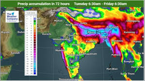
Source: weather.com

The Indo-Gangetic plain has been witnessing very heavy rainfall since Tuesday. As the monsoon gains strength over the region, the rains are forecast to increase and persist throughout the week.

On Tuesday, some areas in Uttar Pradesh witnessed torrential rainfall, with Bahraich recording 202 mm. Other regions, including Gorakhpur and Sultanpur in UP and Bhagalpur in Bihar, also witnessed rainfall of around 100 mm.

More rains are expected from Wednesday to Friday as the atmospheric circulation over the region is expected to be active. The cause for the downpour is a monsoon trough—an extended region where the atmospheric pressure is the lowest—that persists from east to west on the Indo-Gangetic plain. The well-marked low-pressure is expected to move up north along the Himalayas gradually. Therefore, in addition to UP and Bihar, Uttarakhand is also likely to experience extremely heavy rainfall this week.

The India Meteorological Department has issued a red warning (its highest level of vigil/action) in Uttar Pradesh from Wednesday to Friday and in Uttarakhand for Thursday and Friday. During this period, the department forecasts heavy to very heavy with extremely heavy rain at isolated places in the region. Bihar also has a yellow ‘watch’ warning for the entire week, with likelihood of heavy to very heavy rain and extremely rain at one or two places.

Normally, monsoon sets in over Uttar Pradesh on or around June 15. However, this year the arrival was delayed by over a week, and the monsoon reached the state only by June 22. The resulting deficit in rainfall in the northern region ranges from 23% in east UP to 31% in West UP and 47% in Uttarakhand from June 1 to July 9.