Gaya: The Land Of Temples And Monasteries

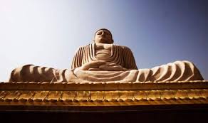
Source: india.com

One of India’s holiest cities, Gaya is a centre for various faiths and beliefs including Hinduism, Jainism and Buddhism. Dotted with ancient temples and monasteries, the structures are testimony to the architectural brilliance of its past. For nature lovers too, Gaya is the perfect setting amidst hills, presenting a picturesque landscape that is calming and rejuvenating.

Vishnupad Temple

Located on the banks of Falgu river, the 18th-century temple is said to be constructed on Lord Vishnu’s footprints. However, the huge temple complex also displays images of various other Gods and Goddesses. There’s even a temple dedicated to Lord Narasimha in the courtyard of the Vishnupad Temple.

Bodhi Tree

Bodhi Tree is where Gautam Buddha had attained spiritual enlightenment. Located on the southern side of Mahabodhi Temple, the tree however is believed to have been grown from a sapling of the original tree in 620 AD. Legend goes that, the Bodhi Tree was destroyed many times; once by Emperor Ashoka’s wife and later by King Sesaka.

Chinese Temple And Monastery

Located near the Mahabodhi Temple, the Chinese Temple was built by the government and the Buddhist monks of China in 1945. The 200-year-old Buddha statue found inside is said to be from China, along with three other golden statues of Buddha. Built in traditional Chinese architectural style, it’s quite a wonder to the eye.

Bodhgaya Archaeological Museum

Established in the 1950s, Bodhgaya Archaeological Museum houses several relics that were unearthed in Gaya. The collections include rare sculptures belonging to the 1st-century BC, antiques of Hindu deities and Buddha made of various metals including gold, bronze and silver.

Royal Bhutan Monastery

Known for its wonderful depiction of the life of Buddha, this monastery was built by the King of Bhutan and ranks amongst the most majestic monasteries in the country. It also houses a beautiful temple with a 7 feet tall Buddha statue inside. The serene atmosphere in the monastery makes it a wonderful place to meditate.

Hazaribagh National Park

Hazaribagh National Park-Jharkhand
About:
The Hazaribagh National Park is one of the most significant wildlife sanctuaries in Jharkhand. The sanctuary is located at a height of about 615 meters on a low-altitude hilly region of the state. The Hazaribagh National Park in Jharkhand spans across a huge region. This national park covers a total area of 184 square kms. The Hazaribagh National Park has a tropical type of climate, where it is quite cold during winter and quite hot during summer.  

The Hazaribagh National Park at Jharkhand offers a variety of vegetation starting from low-altitude stretches of grassland to thick tropical vegetations. The wildlife sanctuary of Hazaribagh National Park has a wide range of topography from low-lying regions to high hills and rolling regions.

The Hazaribagh National Park has abundant wild animals like the Chital, Nilgai, Panther, Sambar, Sloth Bear, Tiger and Wild Boar. The Cheetal, Kakar, Nilgai, Sambar and Wild Boar are among the most easily and often spotted animals particularly near the waterholes at the time of the dusk. The population of the tigers is very less. According to 1991 Census, there were 14 tigers in the park. The tigers are really difficult to sight.

A 111-km long stretch of the road in the sanctuary takes the tourists to the remotest corners and masonry towers of the park. The road, strategically laid down, offers excellent opportunities for the view of the wild animals. The tribal population also lives around the sanctuary. The ark has many watchtowers that act as the perfect hideouts to see the wildlife in its natural surroundings.
Location info:
Address:Hazaribagh National Park, Koderma,Jarkhanad,India
District: Koderma
Nearest City: Koderma
Best time to visit: October to March
Climate/Weather:
The climate in this region is tropical with hot summers and cold winters. Temperature during the summer months touch a high of 41.1’C and a low of 19.4’C. Winter months are better and the temperature ranges between a maximum and minimum of 19.4’C and 7’C. The monsoon months are July to mid-September.
History:
Eversince the Hazaribagh National Park was developed in 1954, it was known by that name but when the formal listings of the national parks was made by the United Nations, it was not included in it.On 24th June 2007, Deputy Chief Minister of Jharkhand announced that soon Hazaribagh will have an state-of-the-art Elephant Park, if this project materialize it would attract more tourist.
Interesting things to do:
Put off all music and cut off all sound. Don’t frighten animals away. Leave the animals to themselves and just watch them from a distance. Also, put your vehicles light dim because too much may frighten the animals.
Interesting things to Visit:
Fauna:
Sambhar, nilgai, chital and kakar can be seen at dusk and dawn, enjoying at water holes. Sloth bear might be encountered unexpectedly. It is a matter of chance that one sees a tiger or a panther. The last time a Tiger was sighted in the vicinity of the Forest Rest House was in 2006, as reported by the caretaker when the Tiger had killed a prey. I was very lucy to watch a Tiger from a distance of barely 30 feets while on foot; But that was way back in 1989. I still cherish the memory.  

Landscape:
The national park is located on the Chotanagpur plateau. It stretches over 184 sq km of undulating countryside, steep hills and deep drainage channels with thick tropical forests and grass meadows, at an average altitude of 615 meters. There are small rivers and a number of dams have been constructed to form artificial lakes within the park.

Hazaribagh Lake:
The Hazaribagh lake also attracts various tourists. It is a popular picnic spot and place for water sports.

Jilaiya Dam:
This dam, situated across Barakar River is a preferred attraction for the tourists. It is 55 kms away from Hazaribagh. The main road from Bath, on C.T Road passes through the reservoir and the hillock offers a breath-taking sight.

Hazaribagh Hill:
Hazaribagh is the famous hill resort to relax and enjoy the natural scenery. Hazaribagh literally means the land of thousand gardens and is situated at an altitude of 2019 feet above the sea level and set amidst hilly and forests on the opposite side of the Damodar Valley. It has excellent climate and scenic beauties all around it in the midst of dense forest which is quite rich in flora and fauna. Hazaribagh is well known for the Hazaribagh Wildlife Sanctuary. This place attracts tourists from all over the world who come here to visit the sanctuary, waterfalls and dams located in the vicinity. The best season to visit Hazaribagh is from October to April.
Mobile range info:
 
How to reach?
Nearest Railway Station: Koderma railway station , which is 59 km away, or alternately one can approach the park from the Hazaribagh Road railway station (67 km) on the Howrah-Delhi Grand Chord line.
Nearest Airport:Ranchi (91 km) ariport is connected with Calcutta, Patna, Lucknow and Delhi by regular Indian Airlines flights.
Road Transport: Hazaribagh town is connected by road to Ranchi 91 km, Dhanbad 128 km, Gaya 130 km, Patna 235 km, Daltongunj 198 km, and Calcutta (via Asansol-Govindapur-Barhi) 434 km. The Hazaribagh National Park is 19 km from the Hazaribagh town. Regular bus services connect the town with Koderma, Hazaribagh Road railway station, Patna, Gaya, Ranchi, Dhanbad, Daltongunj and other nearby places.Unmetered Taxis, Auto Rickshaws, Cycle Rickshaws and Taxis are available for the park from the Hazaribagh town. The approximate charge for a taxi is Rs. 160 for a two-way journey.
Nearest Visiting places:
Rajarappa Waterfalls:
Rajarappa Waterfalls is situated about 89 km. from Hazaribagh. The Rajarappa Waterfalls is believed to be one of the 51 sacred sites where a part of the body of Sati, the spouse of Lord Shiva fell. In this falls, the Bhera river joins the Damodar river from a height of 20 feet. A temple dedicated to Devi Chinnamasta is situated on the top of the hill. The little waterfall also offers boating facilities which introduces some very spectacular rock formations in this area.  

Tilaiya Dam:
Tilaiya Dam is a small dam that is situated on the Patna-Ranchi road and 55 kms from Hazaribagh. This dam produces only 4000 kw. of power. This was the first dam and hydro-electric power station that was built by the Damodar Valley Corporation for controlling floods across Barakar river in Hazaribagh district. It is 1,200 ft. long and 99 ft. high. It is situated in an ideal surrounding with a reservoir stretching in 36 sq. kms. This dam is mainly visited for its picturesque setting with its hills and reservoir with motor boats, swimming, terrace gardens and deer park.

Canary Hills:
The Canary Hills is located close to the town. The Canary Hills has a well laid out park and studded with three small lakes and an observation tower. From the top of the hill one can have a panoramic view of the town.

Parshnath Temple:
Parshnath Temple is situated at the top of the Parshnath Hill, the highest hill in the Giridih district in Bihar. It is situated about 200 km. from Pawapuri and 8 km. from Giridh. The path to the hill top passes through the Madhuban village from where it is an 11 km. trek. It takes almost a full day to reach the Parshnath Hill and to the temple and to come back. The Parshnath Hill is a famous abode for Jains as about 23 out of 24 Tirthankaras (including Parsvantha) are believed to have attained salvation in the Sammetasikhara of the Parshnath hills. The Parshnath hill is named after the 23rd Tirthankar Parsvanatha and rises steep above the plains of Dhanbad to a height of 1,365 metres. The Prasvantha, 23rd Tirthankar was very popular among tribal population of Chotanagpur. He is identified by the snake king Dharanendra, whose many hoods protect the meditating Tirthankar. Both the Swetamber and Digamber Jains have many beautiful temples here on the hills.

Shahpur:
Opposite Daltonganj on the west bank of the Koel is the village SHAHPUR in which Gopal Rai, the Raja of Palamu built a palace in the end of the 18th century. Shahpur stands on a high tract of land and the ruined place, the white temple and the masonry building present a picturesque view from Daltonganj. A nearer view of the palace is disappointing for what looks in the distance like an imposing edifice is seen to be half-finished building of little architectural importance.

Palamau:
Palamau on the Auranga river , 20 miles south-east of Daltonganj as the crow flies, from which the district takes its name is for historian and archaeologist the most interesting place in the district, for it was for many years the seat of the Chero chiefs and it contains the ruins of the two great forts built by them, the capture of which by Mughals and later by the British resulted in the collapse of the Chero resistance, the forts lie within the reserved forests and in order to preserve them the jungle has to be cut back at intervals .they are a favourite haunt of tigers, whose pug marks may nearly always be seen in and around the fort.The walls which are in preservation are about 5 feet in thickness and those of the old fort bear marks of cannon balls and bullets in many places.

Netarhat:
The plateau of Netarhat in Palamu district is comparatively unknown to the tourists from outside although it is one of the rare beauty spots which is capable of great development. About a century back, it is understood, there was a military camp at Netarhat. The camp had to close down because sufficient good water was not available. It was left to Sir Edward Gait, Lt. Governor of Bihar and Orissa to give a great Importance to the plateau. Sir Edward and after him many of the Bihar and Orissa and later Bihar Governors use to spend a part of the summer exodus at Netarhat. Netarhat although situated in Palamau District is more easily accessible from Ranchi, the summer headquarter of the Old Bihar Govt. it is at a distance of 96 miles from Ranchi, the last 12 miles of which commencing from Banari runs through the hilly section and is typical of any of the other hill stations. There is an excellent all-weather road of morum which is capable of widening at some places. The cars can pass conveniently.
plateau:
A plateau, four miles long and two and a half miles broad. It is in the extreme of the district, the highest point of which is 3,800 feet above the sea level. It is in Mahuadanr police station and is 96 miles west of Ranchi across seven hills. This is the highest point on the plateau of Chhotanagpur. Netarhat is a place of peculiar charm which has a laid its spell on many casual visitors. The stillness of the jungle and the cool and refreshing air brings relief from the dust and heat of the plains. Netarhat has a game sanctuary amidst pine forest the bestow singular arboreal interest in this part. Some time back it used to be the permanent summer station of the Governor.

Palamau National Park:
Palamau is one of the popular national parks of India. Palamau is situated within the lndo-Malayan realm and is rich in flora and fauna, though the area is prone to severe droughts. There are 107 villages in the buffer area and three in the core with a human population of 65,000 and a livestock population of 45,000. The core is distributed into two parts, the actual core and the recently inducted ‘satellite core’. The park was brought under Project Tiger in 1973 and is among the first nine Tiger Reserves of the country. The core area was declared a National Park in September 1989.

Betla National Park:
Situated in the district of Daltonganj, Palamau Sanctuary is spread over an area of 979sq.km. The core area of 232 sq. kms of the sanctuary was declared as Betla National park in September1989. The park occupies the western parts of the Chotanagpur plateau and was constituted in the year 1960 as an extension of the Hazaribagh National park. Palamau has the distinction of being the forest where the world’s first tiger census was enumerated in 1932. The park became one of the earliest 9 tiger reserves in India under ‘Project Tiger’ in 1974.
Nearest Petrol Pump:
Lakshmi petrol pump:NH 100,Hazaribagh,Jharkhand,India  
Koltex petrol pump:NH 100,Hazaribagh,Jharkhand,India
Ramnagar Petrol pump:Road No 4,Hazaribag,Jharkhand,India
Hotels/Lodge/Accommodation:
Lotus Nikko Bodhgaya Hotel:Bodhgaya,Gaya,Bihar,India  
Hotels Bodh Gaya:Bodhgaya,Gaya,Bihar,India
Things to carry:
 
Tips & Suggestions:
 
Help Line/Phone Number:
Police Station:100
Nearest Hospital:
Holy Family HospitalL::Koderma,Jharkhand,India
Sadar Hospital Hazaribagh:NH 100,Hazaribag,Jharkhand,India
Society/Community Phone Number:
Link:

Valmiki national park

Valmiki national park-Bihar
About:
The Valmiki National Park is well dispersed across a pulsating plot that approximately measures 335.64 square kilometers and is sited in the western outskirts of the territorial domain named Champaran that forms a part of the premises of Bihar. Incidentally the Valmiki National Park is a wee fragment of the mammoth Valmiki Sanctuary that covers a sprawling area of around 800 square kilometers.  

The Valmiki National Park made its innocuous presence felt in the early 1990s and since then has procured an apt abode to the flamboyant and majestic creatures regarded as the tigers. In fact, the Valmiki National Park vanquishes the fourth spot in the standings of the reserves that houses maximum number of tigers.

The placid waters of the rivulet called Gandak and the magniloquent apex of the Mount Everest on the western fringe presents a serene and timid ambiance to the Valmiki National Park at Bihar where the king of the beasts can stomp around on the lush grasses with pride and elation.

The Valmiki tract is broken and undulating often showing highly fragile geological formations. As a result, there are steep ravines, knife-edge ridges and precipitous walls formed by landslips and soil erosion.

The great Gandak and the Masan rivers collect all the water from the numerous, tortuous tributaries. These rivers and streams keep changing course from side to side, facilitated by the erosion-prone sandy and immature soil of the banks. Seasonal rivers like Panchanad, Manor, Bhapsa and Kapan display peculiar behaviour of erosion at one place and deposition of transported soil at another place.

Hill system is the continuation of Siwalik Range, largely made of imperfectly compacted and ill-formed sandstone dotted with pebbles and boulders. Owing to the fragile nature of parent rock material, the soil produced at the foothill is immature, loose sand and display sheet. The menace is further aggravated by maltreatment of the forests by people in general, frequent fires and heavy grazing.

The park consists of moist Sal bearing forests, dry Sal bearing forests, moist mixed deciduous forests without Sal, cane and tropical seasonal swamp forests containing reed beds and wet grasslands. The species found in the park include tiger, sloth bear, wolf, various species of deer, serow, leopard, python, peafowl, chitals, sambars, nilgais, leopards, hyenas, Indian civets, Jungle cats, Hog deer, wild dogs etc. One horned rhinoceros and Indian bison often migrate from Chitwan to Valmikinagar. There are 8 villages in the buffer area but no habitation in the core area.
Location info:
Address:valmiki national park ,Patana,Bihar,India
District: Patna
Nearest City: Valmiki nagar
Best time to visit: October to February
Climate/Weather:
Summer: 43 °C – 30 °C, Winter: 21.4 °C – 5 °C
History:
The Valmiki Tiger Reserve, the 18th Tiger Reserve of the country and second in Bihar, is located in the northern most part of the West Champaran district of the State. Core area was declared as a National Park in 1989. Government of Bihar had notified 464.60 sq. km. area as Valmiki Wildlife Sanctuary in 1978. Later on, in 1990 an area of 419.18 sq. km. was added to the Sanctuary. Thus Valmiki Wildlife Sanctuary embraces a total area of 880.78 sq. km.
Interesting things to do:
 
Interesting things to Visit:
Lauriya Nanadan Garh: 
There is lion pillar of Ashoka, which is a single block of polished sand stone, 32′-9.5″ in height with a diameter of 35.5″ at base and 26.2″ at the top. The pillar is over 2000 year old and in excellent condition. Nandgarh is a huge mound composed of bricks and is about 80 feet height. According to a authoritative source, it is an Ashok Stupa in which ashes of Buddha’s funeral pyre were enshrined.  

Bawan Garhi: 
A name meaning 52 forts. It is also known as Tripan bazar. The remains of 52 forts and Tripan bazar are at Darubari.

Someshwer Fort: 
Someshwar Fort is situated in Narkatiagani sub-division, near Nepal border, on top of the Someshwar hill at 2884 ft above M.S.L. It is in ruined state but its remains are well defined.

Triveni: 
A holy place of Hindu. The name is derived from the fact that three rivers (Gandak, Sonha and Pachanad) merge here soon after they emerge from the hills. Triveni is also believed to be the site at which the fight commenced between Lords of Forest and Water (the Elephant and Crocodile).
Forest:
Bhabar Dun Sal Forest ,Dry Siwalik Sal Forest ,West Gangetic Moist Mixed Deciduous Forest ,Khair – Sisso Forest ,Cane brakes ,Eastern Wet Alluvial Grassland , Barringtonia Swamp Forest .

Flora:
Sal (Shorea robusta), Asan, Karama, Semal, Khair, Cane(Calamus tenuis), Jamun, Siccharrum, Mahulan, Piper, Lagun (Peepar)
Main Species:
Tiger, Leopard, Fishing Cat, Leopard Cat, Chital, Sambar, Hog Deer, Black Buck, Gaur, Sloth Bear, Langur, Rhesus Monkey .
fauna and flora:
There is no poaching in core area. Poaching is occasional in the buffer area but as the northern and Western boundaries of the Reserve lie along Nepal and Uttar Pradesh respectively. There is serious problem of poaching and smuggling of teak and cane from Madanpur block of the Reserve to different parts of Nepal e.g. Susta, Ratanganj and Rani Nagar. Armed gangs settled in Nepal are involved in illicit felling.

Valmiki temple:
A Valmiki temple is called an Ashram, which means a hermitage or monastery. It is the communal house for Valmikis. The function of the Ashram is to serve as a center for building up the commitment of devotee’s and for transmitting the Ramayana’s message, and the focal point for the whole community to preserve their culture and traditions.The Ashram is open to all who wish to enter, anyone who goes to the Ashram is welcome to stay as long as they wish and are welcome regardless of race, gender, caste or creed.

Kutagarshala:
It lies at a distance of 3 kilometers from the main town and was constructed by the Lichchavis for Sakhamuni. A large tank, open courtyard and verandah are all that is left of this once famous monastery. In the north of this very site is the Ashokan pillar to commemorate the place where Buddha delivered his last sermon.Amvara or Amrapali’s mango grove: Amrapali the famous courtesan gifted here mango orchard Amvara to the Buddhist Sangha after she heard Buddha delivered his sermon.The ruins of Kings Vishala’s fort from whom the town gained its name, is also a major Tourist Attractions in Vaishali. Abhisekh Puskarini is the sacred coronation tank. The Japanese temple built by Nipponzan Myohoji sect of Japan is another interesting place in Vaishali. Sonepur:
A small sleepy town close to Hazipur, Sonepur comes alive every year on Kartik Purnima when one of the largest cattle fairs of Asia is organised. A whole lot of people turn up to be a part of this fair from both India and abroad. The Bihar state Tourism Development Corportaions make accommodation arrangements in traditional huts for visitors coming to this fair. Muzaffarpur:
Muzaffarpur is located 35 km from Vaishali and is also known as the lychee kingdom. In ancient times, it is believed, Muzaffarpur, along with the modern district of Champaran and Darbhanga, formed the Lichchavi kingdom. Today, the city is one of the most important one in north Bihar and has plenty of historical sites in closeby areas to roam around.
Mobile range info:
 
How to reach?
Nearest Railway Station:The Valmiki Nagar rail head is 5km from the park.
Nearest Airport:Patna airport is at Patna at a distance of 295km.
Road Transport:There are bus services from Valmiki Nagar to Bettiah ( 80km) the nearest town.
Nearest Visiting places:
Gol Ghar:
This bee hive shaped granary was built in the year 1770 after the outbreak of a terrible famine. It is one of the oldest British structures in the city and once you reach its top after climbing a series of steps, you will get a good view of the River Ganges and the city.This enormous beehive-shaped structure was constructed as a state granary. A series of surrounding steps lead to the top of this huge building that commands a nice view of the river Ganges and Patna city.  

Harmandirji:
Built by Maharaja Ranjit Singh, this dome shaped structure houses many Sikh scriptures and personal belongings of Guru Gobind Singh.The shrine was built to consecrate the birthplace of Guru Gobind Singh, the tenth Sikh Guru (prophet). Many Sikh scriptures and the personal belongings of the prophet are preserved in this dome-shaped structure.

Kumhrar:
Nearly 5km away from Patna, this is the site of ancient Mauryan capital Patalipra. A huge 80-pillared hall of the Mauryan dynasty is an important find from the excavation.An archaeologist’s delight, this spot is marked by a huge 80 pillared hall. It is actually the ruins of Ashokan Pataliputra which in its heyday was comparable to Venice of the East.

Jalan Museum:
The Museum has been constructed at the site of the fort of Sher Shah. The personal museum preserves a great collection of jade, Chinese paintings and silver filigree work of the Mughal period.The personal collection of Diwan Bahadur Radhakrishnan Jalan is housed in this museum. The jade collection, the beautiful Chinese paintings and the exquisite filigree work of the Mughal period form a part of its excellent repertoire.

Agam Kuan:
This archeological remains of a deep well is one of the major tourist attractions in Patna. It is believed to be associated with the time of Ashoka.Believed to date back to the Ashokan period, this deep well draws a large number of visitors.

Patna Museum :
Locally known as the Jadu Ghar, this museum houses an amazing collection of bronze sculptures and terracotta figures. Its most precious object is the Didarganj Yakshi.The museum displays a prized collection of archaeological finds from different sites in Bihar. Metal and stone sculptures of the Maurya and Gupta Periods, terracotta figurines, ashes of the Buddha and a 16meters long fossilized tree feature among the exhibits. Patna Museum. The museum boasts of an amazing collection of Buddhist art, dating back to somewhere around 8th century AD to 12th century AD. The most magnificent pieces of art consist of the statues of Avalokitesvara and Maitreya. Apart from that, the city also houses some large pillars and the foundations of a Buddhist Monastery, known as Anand.
Nearest Petrol Pump:
Petrol Pump:Bhagalpur,Bihar,India   Petrol Pump:Bhagalpur,Bihar,India
Hotels/Lodge/Accommodation:
Nand Hotel:Sabzi Market,Saharsa,Bihar,India   Satkar Hotel:Saharsa,Bihar,India Sana Rest House:Saharsa,Bihar,India
Things to carry:
 
Tips & Suggestions:
 
Help Line/Phone Number:
Police Station:100
Nearest Hospital:
Sadar Hospital:Khagaria,Bihar,India
Sadar Hosiptal:Begusarai,Bihar,India
Refinery Township Hospital:Begusarai,Bihar,India
Society/Community Phone Number:
Link:

MAITHAN DAM

MAITHAN DAM
About:
They are Maithan and Tilayia dams. Maithon dam is a very famous tourist spot because of its exquisite locale and tranquil ambiance. It is built on Barakar at a place known Maithon in the Dhanbad district while Tilayia is a dam in the Hazaribagh district. Its there in the history of Barakar river as well as in the present also that it creates huge havoc during monsoons in the upper reaches by bringing massive floods. The fury can be estimated from the fact that not once but twice it drowned two bridges constructed successively on the Grand Trunk Road that passes through it.Maithan means ‘Mother’s Home’. This dam, 15,712 ft long and 165 ft high, is built over the Barakar River and has been designed for flood control.  

The Maithon reservoir lake, spread over an area of 65 sq.km, offers boating and fishing facilities to tourists. There is also a rest house on an island in the middle of the lake. A deer park and bird sanctuary can be visited nearby. Maithon Dam has a unique underground power station which is the first of its kind in the whole of South East Asia. Visiting the power station requires prior permission. Maithan Dam, It is 52 km from Dhanbad. Maithon can also be translated as “Mother’s Abode”. Maithon has the biggest reservoir in the Damodar Valley Corporation. This dam, designed for flood control, has been built on the Barakar river. It has a unique underground power station which is first of its kind in S.E. Asia. Just a little away from the dam lies an ancient temple at Kalyaneshwari.

The lake at Maithon is spread over an area of 65 sq.kms. On an island in the lake is a rest house which offers accommodation. Boating and fishing facilities are available. Close by, a deer park and a bird sanctuary have been established. The name Maithon literally means mother`s abode. Situated on the banks of the Damodar River, the major attraction of the town is a lake. The lake covers an area of 65 sq km. and offers boating and fishing facilities.

Near the lake there is a bird sanctuary and a deer park. The Maithon Dam constructed on the Barakar River is another prime attraction for visitors. The Maithon dam was built with the objective to control floods. It also has an underground power station, which is the only one in South East Asia. A few kilometers from the Dam there is an ancient temple named Awake Temple at Kalyaneswari.
Location info:
Address:Maithan Dam,Dhanbad,Jarkhand,India
District:Dhanbad
Nearest City:Hazaribagh
Best time to visit: October to March
Climate/Weather:
Summers 16°- 41°C. Winters 1°-28°C
History:
Literally meaning Mother’s Abode, it is the biggest reservoir of the Damodar Valley Corporation (DVC). This dam, designed for flood control, has been built on the Barakar river. It has a unique underground power station which is first of its kind in SE Asia. Just a little away from the dam lies an ancient temple at Kalyaneshwari. The lake at Maithon is spread over an area of 65 sq. km. There is a rest house on an island in the lake. Boating and fishing facilities are available. Close by, a Deer Park and a bird sanctuary are also situated.
Interesting things to do:
 
Interesting things to Visit:
Dam :
The Maithon Dam, located 48 kms from Dhanbad, is 15,712 ft long and 165 ft. high. This dam specially designed for flood control generates 60000-k Watt of electricity. The unique feature that sets it apart from the rest is that there is an underground power station, first of its kind, in whole of SouthEast Asia. The dam is constructed on the Barakar River.Prior permission is required for visiting the powerhouse. The permits are issued from the office of the Assistant Public Relations Officer and guide services are also made available.  

Barakar river:
The whole catchment area of Barakar River at Jharkhand is 6159 square kilometers. The two main tributaries of Barakar River in Jharkhand are Barsoti and Usri which flow in the direction of south to north. The Barakar River flows across the districts of Hazaribagh, Dhanbad and Giridih at Jharkhand. Another fact about Barakar River at Jharkhand is that it has two dams standing over it. The main tourist attraction at the banks of Barakar in Jharkhand is the Parashnath Hill at an altitude of 4470 feet in the Giridih district of Jharkhand. Another tourist attraction near Barakar River is the pilgrimage of the Jains named Bhagvan Mahavir Swami Jain Teerth.

Jilaiya Dam:
This dam, situated across Barakar River is a preferred attraction for the tourists. It is 55 kms away from Hazaribagh. The main road from Bath, on C.T Road passes through the reservoir and the hillock offers a breath-taking sight.
Hazaribagh Hill:
Hazaribagh is the famous hill resort to relax and enjoy the natural scenery. Hazaribagh literally means the land of thousand gardens and is situated at an altitude of 2019 feet above the sea level and set amidst hilly and forests on the opposite side of the Damodar Valley. It has excellent climate and scenic beauties all around it in the midst of dense forest which is quite rich in flora and fauna. Hazaribagh is well known for the Hazaribagh Wildlife Sanctuary. This place attracts tourists from all over the world who come here to visit the sanctuary, waterfalls and dams located in the vicinity. The best season to visit Hazaribagh is from October to April.
Mobile range info:
 
How to reach?
Nearest Railway Station: Dhandad railway station is an important railhead on Eastern Railway. Several express and super-fast trains ply to Dhanbad from Patna, Kolkata, Delhi and other important cities of India.
Nearest Airport:Ranchi aiport at (175km) and Patna airport at(325 km)
Road Transport:Good network of roads connect Dhanbad with important town in Jharkhand and Bihar. Buses are available from Dhanbad to Bokaro (84 km), Ranchi (169 km) and other places of Jharkhand. Chartered buses or taxis are arranged to Dhanbad from Ranchi and Patna by Bihar State Tourism Development Corporation at regular intervals.
Nearest Visiting places:
Rajarappa Waterfalls:
Rajarappa Waterfalls is situated about 89 km. from Hazaribagh. The Rajarappa Waterfalls is believed to be one of the 51 sacred sites where a part of the body of Sati, the spouse of Lord Shiva fell. In this falls, the Bhera river joins the Damodar river from a height of 20 feet. A temple dedicated to Devi Chinnamasta is situated on the top of the hill. The little waterfall also offers boating facilities which introduces some very spectacular rock formations in this area.

Tilaiya Dam:
Tilaiya Dam is a small dam that is situated on the Patna-Ranchi road and 55 kms from Hazaribagh. This dam produces only 4000 kw. of power. This was the first dam and hydro-electric power station that was built by the Damodar Valley Corporation for controlling floods across Barakar river in Hazaribagh district. It is 1,200 ft. long and 99 ft. high. It is situated in an ideal surrounding with a reservoir stretching in 36 sq. kms. This dam is mainly visited for its picturesque setting with its hills and reservoir with motor boats, swimming, terrace gardens and deer park.

Canary Hills:
The Canary Hills is located close to the town. The Canary Hills has a well laid out park and studded with three small lakes and an observation tower. From the top of the hill one can have a panoramic view of the town.

Parshnath Temple:
Parshnath Temple is situated at the top of the Parshnath Hill, the highest hill in the Giridih district in Bihar. It is situated about 200 km. from Pawapuri and 8 km. from Giridh. The path to the hill top passes through the Madhuban village from where it is an 11 km. trek. It takes almost a full day to reach the Parshnath Hill and to the temple and to come back. The Parshnath Hill is a famous abode for Jains as about 23 out of 24 Tirthankaras (including Parsvantha) are believed to have attained salvation in the Sammetasikhara of the Parshnath hills. The Parshnath hill is named after the 23rd Tirthankar Parsvanatha and rises steep above the plains of Dhanbad to a height of 1,365 metres. The Prasvantha, 23rd Tirthankar was very popular among tribal population of Chotanagpur. He is identified by the snake king Dharanendra, whose many hoods protect the meditating Tirthankar. Both the Swetamber and Digamber Jains have many beautiful temples here on the hills.

Shahpur:
Opposite Daltonganj on the west bank of the Koel is the village SHAHPUR in which Gopal Rai, the Raja of Palamu built a palace in the end of the 18th century. Shahpur stands on a high tract of land and the ruined place, the white temple and the masonry building present a picturesque view from Daltonganj. A nearer view of the palace is disappointing for what looks in the distance like an imposing edifice is seen to be half- finished building of little architectural importance.

Palamau:
Palamau on the Auranga river , 20 miles south-east of Daltonganj as the crow flies, from which the district takes its name is for historian and archaeologist the most interesting place in the district, for it was for many years the seat of the Chero chiefs and it contains the ruins of the two great forts built by them, the capture of which by Mughals and later by the British resulted in the collapse of the Chero resistance, the forts lie within the reserved forests and in order to preserve them the jungle has to be cut back at intervals .they are a favourite haunt of tigers, whose pug marks may nearly always be seen in and around the fort.The walls which are in preservation are about 5 feet in thickness and those of the old fort bear marks of cannon balls and bullets in many places.

Netarhat:
The plateau of Netarhat in Palamu district is comparatively unknown to the tourists from outside although it is one of the rare beauty spots which is capable of great development. About a century back, it is understood, there was a military camp at Netarhat. The camp had to close down because sufficient good water was not available. It was left to Sir Edward Gait, Lt. Governor of Bihar and Orissa to give a great Importance to the plateau. Sir Edward and after him many of the Bihar and Orissa and later Bihar Governors use to spend a part of the summer exodus at Netarhat. Netarhat although situated in Palamau District is more easily accessible from Ranchi, the summer head quarter of the Old Bihar Govt. it is at a distance of 96 miles from Ranchi, the last 12 miles of which commencing from Banari runs through the hilly section and is typical of any of the other hill stations. There is an excellent all-weather road of morum which is capable of widening at some places. The cars can pass conveniently.
plateau:
A plateau, four miles long and two and a half miles broad. It is in the extreme of the district, the highest point of which is 3,800 feet above the sea level. It is in Mahuadanr police station and is 96 miles west of Ranchi across seven hills. This is the highest point on the plateau of Chhotanagpur. Netarhat is a place of peculiar charm which has a laid its spell on many casual visitors. The stillness of the jungle and the cool and refreshing air brings relief from the dust and heat of the plains. Netarhat has a game sanctuary amidst pine forest the bestow singular arboreal interest in this part. Some time back it used to be the permanent summer station of the Governor.

Palamau National Park:
Palamau is one of the popular national parks of India. Palamau is situated within the lndo-Malayan realm and is rich in flora and fauna, though the area is prone to severe droughts. There are 107 villages in the buffer area and three in the core with a human population of 65,000 and a livestock population of 45,000. The core is distributed into two parts, the actual core and the recently inducted ‘satellite core’. The park was brought under Project Tiger in 1973 and is among the first nine Tiger Reserves of the country. The core area was declared a National Park in September 1989.

Betla National Park:
Situated in the district of Daltonganj, Palamau Sanctuary is spread over an area of 979sq.km. The core area of 232 sq. kms of the sanctuary was declared as Betla National park in September1989. The park occupies the western parts of the Chotanagpur plateau and was constituted in the year 1960 as an extension of the Hazaribagh National park. Palamau has the distinction of being the forest where the world’s first tiger census was enumerated in 1932. The park became one of the earliest 9 tiger reserves in India under ‘Project Tiger’ in 1974.
Nearest Petrol Pump:
Dhanbad Petrol Pump:Dhanbad,Jharkhand,India,Ph:02224547
Hotels/Lodge/Accommodation:
Bombay Hotel:Dhanbad,Jharkhand,India,ph:0326-305589   Hotel Sushant International:Dhanbad,Jharkhand,India Hotel Samrat:Dhanbad,Jharkhand,India
Things to carry:
 
Tips & Suggestions:
 
Help Line/Phone Number:
Police Station:100
Nearest Hospital: 
TATA Central Hospital:Jamadoba,Dhanbad,Jharkhand,India
Bokaro General Hospital:Bokaro,Jharkhand,India
Society/Community Phone Number:
Link:

PANCHET

PANCHET-Jarkhand
About:
Panchet Dam is 22,155 ft long and 134 ft high and is made across the Damodar River. The dam is located in Dhanbad District of Jharkhand. A part of Damodar Valley Corporation, Panchet Dam is known to be one of the most important hydel power stations, with a generating capacity of 40 MV power.  

This dam is eventually becoming a place of tourist attraction. An inspection bungalow, supervised by Damodar Valley Corporation, caters to the accommodation needs. Kumardubi Railway Station lies almost 10 km away and is the nearest railhead. Bus services are available from Barakar, Maithon, Asansol and Dhanbad (50 km) to reach the Panchet Dam.

Panchet Dam and Reservoir, an important member of Damodar Valley corporation group of reservoirs built on Barakar liea at the western fringe of Raniganj Coalfield of east India. This Damodar river rises in the eastern part of Palamau district of Bihar at an elevation of approximately 600 mt and has a course of 538 kms before it merges with Hooghly in West Bengal. The basin of this river deposited and is surrounded by the qranite gneiss of chhrta nagpur marked dreaks in the river cores and its tributaries) are affected by the boundary fault scarps.

The Catchments of this river receives an average rainfall of 120-150 cm of which 90% rainfall occurs during the four months only i.e. June to Sept. of a year. In addition to this, valley receives rainfall from tropical cyclones in the upper catchments plateau part of the area. As mentioned above the concentrated rainfall during the monsoon over cneissic rocks, sandstones and shale under hot and humid climate causes severe erosion of rock materials and thereby loading the water streams with great amount of sediments.
Location info:
Address:Panchet Dam,Dhandad,Jarkhand,India
District:Dhandad
Nearest City:Dhandad
Best time to visit: October to March
Climate/Weather:
Summers 16°- 41°C. Winters 1°-28°C
History:
Literally meaning Mother’s Abode, it is the biggest reservoir of the Damodar Valley Corporation (DVC). This dam, designed for flood control, has been built on the Barakar river. It has a unique underground power station which is first of its kind in SE Asia. Just a little away from the dam lies an ancient temple at Kalyaneshwari. The lake at Maithon is spread over an area of 65 sq. km. There is a rest house on an island in the lake. Boating and fishing facilities are available. Close by, a Deer Park and a bird sanctuary are also situated.
Interesting things to do:
 
Interesting things to Visit:
Damodar Valley:
The Damodar Valley Corporation, popularly known as DVC, is the first multipurpose river valley project of independent India. The corporation came into being on July 7, 1948 by an Act of the Constituent Assembly of India (Act No. XIV of 1948). [1] It is modelled on the Tennessee Valley Authority of the USA. Jawaharlal Nehru, prime minister of India, Dr. B.C.Roy, chief minister of West Bengal and Sri Krishna Sinha, chief minister of Bihar, took personal interest to ensure early success of the project.  

Jilaiya Dam:
This dam, situated across Barakar River is a preferred attraction for the tourists. It is 55 kms away from Hazaribagh. The main road from Bath, on C.T Road passes through the reservoir and the hillock offers a breath-taking sight.

Hazaribagh Hill:
Hazaribagh is the famous hill resort to relax and enjoy the natural scenery. Hazaribagh literally means the land of thousand gardens and is situated at an altitude of 2019 feet above the sea level and set amidst hilly and forests on the opposite side of the Damodar Valley. It has excellent climate and scenic beauties all around it in the midst of dense forest which is quite rich in flora and fauna. Hazaribagh is well known for the Hazaribagh Wildlife Sanctuary. This place attracts tourists from all over the world who come here to visit the sanctuary, waterfalls and dams located in the vicinity. The best season to visit Hazaribagh is from October to April.
Mobile range info:
 
How to reach?
Nearest Railway Station:Dhandad railway station is an important railhead on Eastern Railway. Several express and super-fast trains ply to Dhanbad from Patna, Kolkata, Delhi and other important cities of India.
Nearest Airport:Ranchi airport (169 km) and Patna airport is(325 km)
Road Transport: Good network of roads connect Dhanbad with important town in Jharkhand and Bihar. Buses are available from Dhanbad to Bokaro (84 km), Ranchi (169 km) and other places of Jharkhand. Chartered buses or taxis are arranged to Dhanbad from Ranchi and Patna by Bihar State Tourism Development Corporation at regular intervals.
Nearest Visiting places:
Rajarappa Waterfalls:
Rajarappa Waterfalls is situated about 89 km. from Hazaribagh. The Rajarappa Waterfalls is believed to be one of the 51 sacred sites where a part of the body of Sati, the spouse of Lord Shiva fell. In this falls, the Bhera river joins the Damodar river from a height of 20 feet. A temple dedicated to Devi Chinnamasta is situated on the top of the hill. The little waterfall also offers boating facilities which introduces some very spectacular rock formations in this area.  

Tilaiya Dam:
Tilaiya Dam is a small dam that is situated on the Patna-Ranchi road and 55 kms from Hazaribagh. This dam produces only 4000 kw. of power. This was the first dam and hydro-electric power station that was built by the Damodar Valley Corporation for controlling floods across Barakar river in Hazaribagh district. It is 1,200 ft. long and 99 ft. high. It is situated in an ideal surrounding with a reservoir stretching in 36 sq. kms. This dam is mainly visited for its picturesque setting with its hills and reservoir with motor boats, swimming, terrace gardens and deer park.

Canary Hills:
The Canary Hills is located close to the town. The Canary Hills has a well laid out park and studded with three small lakes and an observation tower. From the top of the hill one can have a panoramic view of the town..

Parshnath Temple:
Parshnath Temple is situated at the top of the Parshnath Hill, the highest hill in the Giridih district in Bihar. It is situated about 200 km. from Pawapuri and 8 km. from Giridh. The path to the hill top passes through the Madhuban village from where it is an 11 km. trek. It takes almost a fully day to reach the Parshnath Hill and to the temple and to come back. The Parshnath Hill is a famous abode for Jains as about 23 out of 24 Tirthankaras (including Parsvantha) are believed to have attained salvation in the Sammetasikhara of the Parshnath hills. The Parshnath hill is named after the 23rd Tirthankar Parsvanatha and rises steep above the plains of Dhanbad to a height of 1,365 metres. The Prasvantha, 23rd Tirthankar was very popular among tribal population of Chotanagpur. He is identified by the snake king Dharanendra, whose many hoods protect the meditating Tirthankar. Both the Swetamber and Digamber Jains have many beautiful temples here on the hills.

Shahpur:
Opposite Daltonganj on the west bank of the Koel is the village SHAHPUR in which Gopal Rai, the Raja of Palamu built a palace in the end of the 18th century. Shahpur stands on a high tract of land and the ruined place, the white temple and the masonry building present a picturesque view from Daltonganj. A nearer view of the palace is disappointing for what looks in the distance like an imposing edifice is seen to be half- finished building of little architectural importance.

Palamau:
Palamau on the Auranga river , 20 miles south-east of Daltonganj as the crow flies, from which the district takes its name is for historian and archaeologist the most interesting place in the district, for it was for many years the seat of the Chero chiefs and it contains the ruins of the two great forts built by them, the capture of which by Mughals and later by the British resulted in the collapse of the Chero resistance, the forts lie within the reserved forests and in order to preserve them the jungle has to be cut back at intervals .they are a favourite haunt of tigers, whose pug marks may nearly always be seen in and around the fort.The walls which are in preservation are about 5 feet in thickness and those of the old fort bear marks of cannon balls and bullets in many places.

Netarhat:
The plateau of Netarhat in Palamu district is comparatively unknown to the tourists from outside although it is one of the rare beauty spots which is capable of great development. About a century back, it is understood, there was a military camp at Netarhat. The camp had to close down because sufficient good water was not available. It was left to Sir Edward Gait, Lt. Governor of Bihar and Orissa to give a great Importance to the plateau. Sir Edward and after him many of the Bihar and Orissa and later Bihar Governors use to spend a part of the summer exodus at Netarhat . Netarhat although situated in Palamau District is more easily accessible from Ranchi, the summer head quarter of the Old Bihar Govt. it is at a distance of 96 miles from Ranchi, the last 12 miles of which commencing from Banari runs through the hilly section and is typical of any of the other hill stations. There is an excellent all weather road of morum which is capable of widening at some places. The cars can pass conveniently.

plateau:
A plateau, four miles long and two and a half miles broad. It is in the extreme of the district, the highest point of which is 3,800 feet above the sea level. It is in Mahuadanr police station and is 96 miles west of Ranchi across seven hills. This is the highest point on the plateau of Chhotanagpur. Netarhat is a place of peculiar charm which has a laid its spell on many casual visitors. The stillness of the jungle and the cool and refreshing air brings relief from the dust and heat of the plains. Netarhat has a game sanctuary amidst pine forest the bestow singular arboreal interest in this part. Some time back it used to be the permanent summer station of the Governor.

Palamau National Park:
Palamau is one of the popular national parks of India. Palamau is situated within the lndo-Malayan realm and is rich in flora and fauna, though the area is prone to severe droughts. There are 107 villages in the buffer area and three in the core with a human population of 65,000 and a livestock population of 45,000. The core is distributed into two parts, the actual core and the recently inducted ‘satellite core’. The park was brought under Project Tiger in 1973 and is among the first nine Tiger Reserves of the country. The core area was declared a National Park in September 1989.

Betla National Park:
Situated in the district of Daltonganj, Palamau Sanctuary is spread over an area of 979sq.km. The core area of 232 sq. kms of the sanctuary was declared as Betla National park in September1989. The park occupies the western parts of the Chotanagpur plateau and was constituted in the year 1960 as an extension of the Hazaribagh National park. Palamau has the distinction of being the forest where the world’s first tiger census was enumerated in 1932. The park became one of the earliest 9 tiger reserves in India under ‘Project Tiger’ in 1974.
Nearest Petrol Pump:
Dhanbad Petrol Pump:Dhanbad,Jharkhand,India,Ph:02224547
Hotels/Lodge/Accommodation:
Bombay Hotel:Dhanbad,Jharkhand,India,ph:0326-305589   Hotel Sushant International:Dhanbad,Jharkhand,India Hotel Samrat:Dhanbad,Jharkhand,India
Things to carry:
 
Tips & Suggestions:
 
Help Line/Phone Number:
Police Station:100
Nearest Hospital:
TATA Central Hospital:Jamadoba,Dhanbad,Jharkhand,India
Bokaro General Hospital:Bokaro,Jharkhand,India
Society/Community Phone Number:
Link:

Tilaiya Dam

Tilaiya Dam-Jarkhand
About:
Tilaiya Dam is another dam built on this river and is constructed by Damodar Valley Corporation across the Barakar River. It is the first Dam and hydroelectric power Station in Kodarma District. The dam is 1,200 ft long and 99 ft high. The dam boasts scenic surroundings with a large reservoir, the length of which extends up to 36 sq km. It was constructed with the mission to control flood and it generates 4 MV power.  

Terrace gardens and Picnic Island with motorboats and swimming corner are available adjoining the dam. There are several tourists` spots around the dam. Tilaiya Dam is 20 km from Koderma Railway Station. The dam is easy to get to by road, availing the Patna-Ranchi Road. At distances of 17 km and 194 km are Barhi and Patna respectively. Vehicles ply between Kodarma and Hazaribagh via Tilaiya Dam. Hazaribagh town is only 55 km away from the dam site.

It is the first Dam and hydro -Electric power Station constructed by Damodar Valley Corporation across Barakar river in Hazaribag district. It is 1,200 ft. long and 99 ft. high. It is situated in an ideal surrounding with a Reservoir streching in 36 sq. kms. The main object is to control floods.The hydro -electric station produces only 4,000k. watt. The beautiful natural surroundings are the attraction to tourists . the main road from Barhi on G.T.road throughreservoir and the hillocks is picturesque.
Location info:
Address:Tilaiya Dam,kamda,Jamshedpur,Jarkhand,India
District:
Nearest City:
Best time to visit:
Climate/Weather:
The landscape of this state is naturally filled in with green woods around is obviously spells a magical note on the climate over here, a pleasant humid throughout the year will really tease the man to ease ever with nature… the best time of visits could be made during the months of February and April.
History:
Jhumri Taliya was once a major mica mining centre. While laying a railroad through Koderma in 1890s, the British first discovered vast mica deposits in this region.[2] Mining activities started soon after and many mining houses were established. CH Private Ltd. of Chatu Ram Bhadani and Horil Ram Bhadani was the predecessor of Mica Kings, which controlled the largest share of mica mining and export activity in the world at a time.
Interesting things to do:
Dance and Music:
“If music be the food of love Play it on” these wonderful lines of Shakespeare will come true with is tribal sojourner’s, they are so attached to the rhythm they create. To list a few of their celebrations are as follows:- Bansuri, Arbansi, Sahnai, Madanvari, Singa, Sankh Mandar, Dhol, dhak, Dhamsa, Nagara, Damama, Karha, Tasa, Jurinagra, Visamdhanki, Thapchanchu,Kartal, Jhanjh,Thala, Manjhira, Ghanta are the musical instruments and the rhythm patterns are based to the folk, they are Akhariya, Domkach, Dohari,Janani,Udasi, Pawas , Jhumta, Pratkali. To name some of the famous folk dancing styles here are Paika Chaw Jadur Karma Nachni Natua Matha Sohari and Lurisayro.  

Arts:
The people here are to be much involved into artistic approaches in whatever they work, to name some of the fame arts in this region could be Oraon Bhitichitra , Santhali Bhitichitra and Jado Patiya are the styles of paintings that still exist.

crafts:
The people of Jharkhand though they are tribal base they are good craftsmen with great workmanship , they excel in terracotta, bamboo-work, Seenk-work, Kasida, Pottery, Stone craft, textiles etc; apart from these they do wonderful body paintings , tattoos, stone cutting, bull painting ( during Bandna) folk painting fresco, sculpting horse, elephant etc; for the uses of rituality. Scroll painting or Paitkar is famous but recently becomes obsolete.

Fairs and festivals:
The rhythmic music and dance, the dazzling lights and multicolor monster dyes at the monastery will express the fever of their festival moods. It has great fun and heroic celebrations throughout these periods. To name a few festivals like Batauli, Bhagta Parab, Binda Mela, Jomnamah and Damurai are the festivals of this state which are celebrated vivaciously.
Interesting things to Visit:
Charak Pathar:
The village is situated in GOVINDPUR development block. It is a very large ancient boulder of white stone. It derives its name from this stone.

Chati Gobindpur:
The village which also is located in GOVINDPUR development block, contains two ancient pillars which are locally associated with Emperor Asoka and the Afghan Chief Sher Shah.It is a very large ancient boulder of white stone. It derives its name from this stone.

Gopalpur:
The village lies in Nirsa-cum-Chirkunda development block. It contains an ancient pillar said to date back to the time of Emperor Asoka. There is also a large stone image said to be of Asoka himself.

Jhinjhipahari:
The village is situated in Baghmara development block . It is said that an ancient temple of Lord Shiva was found when the mines here were being worked.It is said that an ancient temple of Lord Shiva was found when the mines here were being worked. t contains an ancient pillar said to date back to the time of Emperor Asoka. There is also a large stone image said to be of Asoka himself.

Meva:
The village is situated in Nirsa-cum-Chirkunda Block . It contains ancient pillars said to date back to the time of Emperor Ashoka. There is also a large stone image said to be of Ashoka himself.t contains ancient pillars said to date back to the time of Emperor Ashoka. There is also a large stone.

Panrra:
The village which also lies in Nirsa-cum-Chirkunda Block, it said to have derived its name from the Pandavas. According to local legend the Pandavas spent some period of their exile in hiding at this place. The village contains an ancient temple of Lord Shiva known as Pandeweshar Mahadev. The temple is believed to have been constructed by Hindu King at a much later day.

Maithon:
It is census town situated about 48 Kms. From Dhanbad and 5 Kms. From Kumardubhi Rly. Station. The Maithon Dam and Hydel Power Stations are located in this town.

Panchet:
This is also a census town situated 9 Kms. South of Chirkunda and about 54 Kms. South east of Dhanbad. The Panchet Dam, around which the Township has developed, is located here.

Jamadoba:
There is a water filter plant of M.A.D.A (Mineral Area Development Authority ) from where water supply is being made to Dhanbad District.

Chark – Khurd: 
The village, situated about 10 Kms from Tundi on the Dhanbad- Govindpur -Giridih Road, is noted for its hot spring.

Topchanchi: 
The village is the headquarters of the development block being the same name. It is situated on the Grand Trunk Road. The Parasnath Hill is located nearby. The Topchanchi Water Reservoir spreads over an area of 214 Ac. It is a noted picnic spot.
Mobile range info:
 
How to reach?
Nearest Railway Station:The Jamshedpur railways is another important transport facility that provides travel from and to nearby states in the country.
Nearest Airport:Ranchi Airport is connecting flights to Delhi, Patna, Mumbai, and Kolkata and nowadays this airport is becoming very busy and popular for the frequency in the air traffic.
Road Transport:The state is well connected with roadways to ply people and goods around the country. There are several private and government transport corporations working enough to serve the people.
Nearest Visiting places:
Baidyanath Dham:
The Baidyanath Dham Deoghar is one of the premier Tourist Attractions in Jharkhand. The Baidyanath Dham Deoghar, Jharkhand comprise the main temple of Baba Baidyanath and 22 other temples. At the main temple of Baba Baidyanath Dham Deoghar, Jharkhand the foreign travelers can find the Jyotirlingam. The Baidyanath Dham Deoghar, Jharkhand is established in a sprawling campus. The Baidyanath Dham Deoghar, Jharkhand experiences an influx of devotees throughout the year. Travelers from different territories and countries of the globe also descend at the Baidyanath Dham Deoghar, Jharkhand for a sacred darshan of the deity.

The Baidyanath Dham Deoghar, Jharkhand is the favorite destination not only for the devotees but also for the international tourists. The Baidyanath Dham Deoghar, Jharkhand is situated in an ideal location. Owing to the strategic location of the Baidyanath Dham Deoghar, Jharkhand the tourists can reach the Baidyanath Dham Deoghar, Jharkhand easily and conveniently. The Baidyanath Dham Deoghar, Jharkhand is situated in the northeastern part of Jharkhand. The Baidyanath Dham Deoghar, Jharkhand is located four miles away from the Jasidih railway terminal. The Baidyanath Dham Deoghar, Jharkhand lies on the main Eastern Railway line. There is a famous railway station which is located in close proximity to the Baidyanath Dham Deoghar, Jharkhand. This railway terminal is known as the Baidyanath Dham railway terminal.

Dassam Falls:
The Dassam Falls, Ranchi is reckoned as one of the major tourist attractions in Ranchi. The Dassam Falls, Ranchi is one of the most spectacular natural wonders of Ranchi. The Dassam Falls, Ranchi is a big draw for the local tourists. The international tourists visiting India come to experience the charm and grandeur of the Dassam Falls, Ranchi. The Dassam Falls, Ranchi is situated about 40 kilomters away from Ranchi. The Dassam Falls, Ranchi is located on the Tata Road. The Dassam Falls, Ranchi is located inside a picturesque village known as the Taimara. The Ranchi Dassam Falls is one of the most picturesque sightseeing locales of India which is situated in the famous tourist destination of Ranchi. Ranchi is located at an altitude of 2140 feet above the sea level. Ranchi is also famous for its wonderful tourist haunts and breathtaking locales. Ranchi is known as the summer capital of the Indian state of Bihar. The beautiful town of Ranchi is interspersed with picturesque hillocks, barren rocks, splendid waterfalls and enchanting sightseeing attractions. The spectacular town of Ranchi boasts of many famous waterfalls which are the major attractions for the local tourists as well as for the international visitors. One of the must do things for the international travelers coming for a tour of Ranchi is to visit the Dassam Falls, Ranchi.

Hundru Falls:
The Hundru Falls, Jharkhand is one of the most famous tourist attractions in Jharkhand. The Hundru Falls, Jharkhand is situated in a small picturesque hamlet. Encircled by lush green forests this spectacular hamlet is situated near the National Highway 47. This enchanting village was established in the year 1950. This fascinating village was built for the Anglo Indian community. Now this beautiful village has become an idyllic vacation retreat for international tourists.

The foreign travelers visiting the Jharkhand Hundru Falls can experience the breathtaking views of the adjacent landscapes. The Hundru Falls, Jharkhand is located about 45 kilometers away from the Ranchi town. Ranchi is a spectacular town, which is dotted with splendid streams and gorgeous waterfalls. The sight of the spectacular Swarnarekha River is indeed a feast to the eyes. The Hundru Falls, Jharkhand fall from a steep height of 320 feet. At the base of the Hundru Falls, Jharkhand the international tourists can find a splendid pool.
The foreign tourists can enjoy a refreshing splash at this wonderful natural pool. This spectacular pool serves as a nice picnic spot. There are also wonderful bathing spots near the Hundru Falls, Jharkhand. The fascinating spectacle of the water falling from such a great height will enchant and mesmerize the foreign visitors. The Hundru Falls, Jharkhand is a splendid natural attraction. The international visitors can also find many notable tourist attractions near the Hundru Falls, Jharkhand. The Hundru Falls, Jharkhand is reckoned as one of the must-see destinations of the Hundru Falls, Jharkhand.

Kolhua Hill:
The Kolhua Hill, Jharkhand is one of the leading tourist attractions in Jharkhand. The Kolhua Hill, Jharkhand measures 1575 feet in height. The Kolhua Hill, Jharkhand is situated about 10 kilometers southeast of Hunterganj. The Kolhua Hill, Jharkhand is located in the Chatra District. The Kolhua Hill, Jharkhand is a favorite haunt for the nature lovers. The international visitors can experience the wonderful and breathtaking view of the adjacent beautiful landscapes from the top of the Kolhua Hill, Jharkhand. The Kolhua Hill is one of the must-visit destinations for the foreign travelers visiting Jharkhand. One of the premier tourist attractions in Jharkhand the Kolhua Hill, Jharkhand receives travelers from al across the globe. The spectacular and fascinating views offered by the Kolhua Hill, Jharkhand is indeed a feast to the eyes. The Kolhua Hill, Jharkhand is one of the most splendid natural attractions of Jharkhand. The top of the Kolhua Hill, Jharkhand is known as the Sky Eye or the Akash Lochan. The Kolhua Hill, Jharkhand is punctuated with verdant landscapes and picturesque surroundings. The foreign visitors can also find many notable tourist attractions near the Jharkhand Kolhua Hill. The splendid tourist attractions located near the Kolhua Hill, Jharkhand include the temple of Goddess Kali and the Kauleshwari Devi Temple. The international tourists can easily reach the Kolhua Hill, Jharkhand as it well connected to the different parts of Jharkhand. The beautiful Lilangen River flows near the Kolhua Hill, Jharkhand. Tourists undertaking excursions from Jharkhand make it a point to view the spectacular Kolhua Hill, Jharkhand. Travelers from all across India flock to Jharkhand to enjoy the scenic vistas of the Kolhua Hill, Jharkhand

Netarhat:
Netarhat, Jharkhand is also popularly called “Queen of Chotanagpur”. Netarhat, Jharkhand is around 154 Km in the western side of Ranchi town which is the Capital city of Jharkhand. Netarhat in Jharkhand is immensely famous for its breathtaking sunrise and sunset. Netarhat in Jharkhand is situated around 3800 ft above the sea level and approximately 96 miles away from the Capital city Ranchi across the known seven hills. This exclusive place is surrounded with the most exotic views, the greenery around facilitates the generation of a pure and tranquil ambience, which brings here a lot of patients to get recovery soon. The calm and quite jungle brings relief from the hustle bustle and rushing life of the metros and cities. The peaceful and soothing atmosphere around the place will make you shed back the whole bag of tension and exertion.

The temperature in Netarhat in Jharkhand tends to be lesser and the atmosphere keeps cool throughout the year than Ranchi. This place has a fame to be the coolest place in entire Jharkhand. Indian travel will make you acquainted to a lot of interesting things one of which is Jharkhand tours and especially the trip to Netarhat. Accommodation is not an issue as a lot of rest houses and inspection bungalows are there to cater to a large number of tourists who are present in abundance throughout the year including documentary filmmakers, wildlife researchers, botanical researchers and other people who come here to study the flora and the fauna or maybe some habits of some rare species.

Betla National Park:
Betla National Park & Palamau in Jharkhand are the most famous sanctuary and National park in Jharkhand. An area as large and vast as 979 sq. Km holds the pride of being termed as Palamau Sanctuary and the most intrigue and core area of which in 1989 was declared as Betla National Park. Betla National Park & Palamau covers the Western part of the plateau of Chotanagpur. In the year 1960 Betla National Park & Palamau in Jharkhand was established and mainly as an extension to Hazaribagh National Park. Palamau has the fame of holding World’s first census of tigers in its deep dark woods in the year 1932. In the year 1974 Betla National Park & Palamau in Jharkhand had become one of the nine tiger reserves of India under the very famous and successful “Project Tiger”. The woods of Betla National Park & Palamau in Jharkhand have a large span of vegetation which consists of moist evergreen forests and local flora and fauna. The forest is a typical formation with tropical and moist evergreen forests around the lower reaches, moist and dry and often mixed deciduous forests in middle and again temperate type of forests around the upper reaches. Bamboo and Sal plays the main features of these forests along with a huge number of plants having high medicinal value and thus are very important to the entire region.

Hazaribagh:
Hazaribagh in Jharkhand is like a crown diamond, Hazaribagh is one of the most acclaimed and visited tourist attractions. Hazaribagh, in literal sense means a thousand gardens. Hazaribagh in Jharkhand is a very renowned health resort; this is situated on a hill around 2019ft above the sea level. This major tourist attraction called Hazaribagh has a very clean and pure atmosphere which is facilitated by the greenery around and thus helps a lot of people who needs to unwind in a healthy ambience. Often doctors prescribe to go and stay here for sometime. During India Travel one should include Jharkhand tours especially the gem of a place or spot known as Hazaribagh. A calm and cool place amidst a dense and large forest giving you a natural feel and get you acquainted with the local wild life where you can find and get close to the Mother Nature.Reaching Hazaribagh is very easy as one can use the National Highway no. 33 and drive down to this exotic place enjoying the tranquil and impeccable beauty surrounding the road, the beauty is filled with the green around including the exotic and huge trees and the dense forest. The beautiful scenic beauty is restored amazingly and it makes you go wild with it, a lot of people including youngsters, kids and elderly people visit Hazaribagh throughout the year.

Kauleshwari Devi:
The Kauleshwari Devi, Jharkhand is one of the most frequented Tourist Attractions in Jharkhand. Pilgrims from all over India pour into the Kauleshwari Devi, Jharkhand especially during Ram Navami and Basant Panchami. The devotees offer sacrifices to the presiding deity of the Kauleshwari Devi, Jharkhand. Goats are often sacrificed at the Kauleshwari Devi, Jharkhand. The Jharkhand Kauleshwari Devi is a famous pilgrimage spot. The Kauleshwari Devi, Jharkhand was established by the Jains. There is a popular myth surrounding the Kauleshwari Devi, Jharkhand.
There is a popular belief that Kauleshwari Devi is the birthplace of Sirala Swami who is the tenth Thirthankara of the Jains. However despite being the birthplace of the tenth Thirthankara the Kauleshwari Devi, Jharkhand has become a popular haunt for the devotees of the famous Hindu goddess Kali. The travelers visiting the Kauleshwari Devi, Jharkhand can find a splendid rock cut temple of the Jains which is housed inside the temple. The international tourists can find many enchanting caves strewn across the campus of the Kauleshwari Devi, Jharkhand.

The foreign visitors can find a beautiful image of a Hindu deity inside a cave of the Kauleshwari Devi, Jharkhand. The hooded image found inside the cave is of Lord Pasarvanath; this is the Dhyani Mudra image of Lord Pasarva Nath who is reckoned as the 23rd Thirthankara of the Jain community. Three Jain images were removed from one of the caves of the Kauleshwari Devi, Jharkhand a couple of years back. The local villagers believe that the images were taken to Gaya (which is another renowned pilgrim spot of the Hindus) for worship. For reaching the Kauleshwari Devi, Jharkhand the foreign visitors have to avail the trek leading to the Kolua Hill.
Lodh Falls:
When you are in Jharkhand, you can explore several sightseeing attractions in the region. Among these places of interest, one natural wonder that you should not miss is the Lodh Falls, Jharkhand. The Lodh Falls, Jharkhand is a waterfall located on the Buddha River and is also known by the name Buddha Ghagh Falls. Lodh Falls, Jharkhand is one of the renowned waterfalls in India. Because of its height and beauty, it is one of the most visited one too. You will find the Lodh Falls, Jharkhand located about 40 kilometers from the city of Ranchi and 60 kilometers from Netarhat. It is nestled in a dense forest in Jharkhand. The fall, which is named after Gautam Buddha, is also renowned for a Buddha Temple here.
The Lodh Falls, Jharkhand is one of the highest waterfalls of Jharkhand and here the water falls from a height of 468 feet. If you want to enjoy the beauty of the falling waters, then you should visit the Lodh Falls, Jharkhand. Even if you are 10 kilometers away from the Lodh Falls in Jharkhand, you can hear the rumbling sounds of water. This waterfall comes down in tiers and drops at distinct levels.
Nearest Petrol Pump:
MK Tanna Petrol Pump:Dhatkidih,Jamshedpur,Jarkhand,India Reliance Petrol Pump:Kandra, Jamshedpur,Jarkhand,India Ashoka PetrolePum:Transport:Parsudih,Jamshedpur,Jarkhand,India
Hotels/Lodge/Accommodation:
Fortune Hotel: Centre Point,2 Inner Circle Rd,Bistupur,Jamshedpur,Purba Singhbhum, Jamshedpur,Jharkhand,India,Ph:0657 2224200 Ganga Regency Hotel:Baradwari,Jamshedpur,Purba Singhbhum,Jharkhand,India Castle Hotel:Bistupur,Jamshedpur,Purba Singhbhum,Jharkhand,India
Things to carry:
 
Tips & Suggestions:
 
Help Line/Phone Number:
Police Station:100
Nearest Hospital:
Jugsalai Hospital:Jugsalai,Jamshedpur,Purba Singhbhum,Jharkhand,India
company hospital:Musabani,Purba Singhbhum,Jharkhand,India
Society/Community Phone Number:
Link:

GONDA HILL

About:
Ranchi and its surroundings are dotted with green hills and white waterfalls, making the capital of Jharkhand one of the major tourist destinations in India. Nature has painted the lands of Jharkhand with beauty. There are numerous hills in and around Ranchi including Tagore Hill, Ranchi Hill and Gonda Hill and Rock Garden. Gonda Hill and Rock Garden is located around four km from the city center of Ranchi, on the Kanke road. It is one of the best places to enjoy holidays. The CMPDI headquarters are located in front of the hill. There is a huge lake at the bottom of the hill known as Kanke Dam, which is a worthwhile retreat. The Kanke Dam manages to spread some enjoyable and peaceful sentiments among the tourists.Tourists from all over the globe come to visit the Gonda Hill and Rock Garden of Ranchi.  

Gonda Hill and Rock Garden as a picnic spot. People come here in massive groups to enjoy some time together. The Gonda Hill houses a water reservoir at its top. At the foot of the Gonda Hill, Kanke village is situated, which houses one of the largest mental asylums in the country. The British designed Kanke Mental Asylum near Gonda Hill, thinking that the cooler environment would be helpful to psychological health. The closeness of the Rock Garden enhances the beauty of the place.
Location info:
Address:Gonda Hill,Ranchi,Jarkhand,India
District: Ranchi
Nearest City: Ranchi
Best time to visit: October to march
Climate/Weather:
Temperature ranges from maximum 37 to 20 °C during summer, and maximum 22 to 10 °C
History:
The spot has been developed into an artificial garden, complete with water falls and sculptures, to attract tourists. The rock garden is awesome in its appearance, striking a balance between the creativity of modern and ancient man. From Ranchi GPO on Kanke road, just in front of the CMPDI Hq. is situated the Gonda Hill with a water reservoir at it’s top. At the foot of the hill is a big lake known as Kanke Dam and an attractive place for the tourists. Rock Garden, Ranchi :- Eloped into an artificial garden, complete with water falls and sculptures, to attract tourists. The rock garden is awesome in its appearance, striking a balance between the creativity of modern and ancient man
Interesting things to do:
Ranchi Lake:
Ranchi Lake, situated in the heart of the city was excavated by Col. Onsely, a British Agent in 1842. It is located near Ranchi Telephone Exchange. The lake has boating facilities.  

Tagore Hill: 
On the periphery of Ranchi is “Tagore Hill”, named after Rabindra Nath Tagore who is believed to have written a part of famous Gitanjali here, besides other poems. Ram Krishna Ashram is situated at the foot of the hill. This hill is very attractive and bigger than “Ranchi Hill”.

Kanke Dam: 
On the other end of Ranchi is the “Kankedam” which is ever crowded with tourists. It is a popular picnic spot.

Jagannath Temple: 
Few kilometers from the Kankedam and 10 km form Ranchi is the 17th century “Jagannath Temple” where the annual “Rath Yatra (Chariot Festival)” is held in the month of June/July.Located 10km. south west of Ranchi is the 17th century Jagannath Temple on a hillock at Jagannathpur. The temple was built in 1691 and its architectural styles resembles the Jagannath temple of Puri. Rath yatra or Car festival similar to that of Puri is held every year in the months of June/July. It attracts thousands of devotees both tribal and non-tribal.
Interesting things to Visit:
 
Mobile range info:
 
How to reach?
Nearest Railway Station:Ranchi is on the South Eastern Railway and is directly connected with Calcutta, Patna, Rourkela etc.
Nearest Airport:Ranchi is connected by regular Indian Airlines services with Calcutta, Patna, Bombay and New Delhi.
Road Transport:Ranchi is situated on National Highway No.23 & 33 and there are nets of good roads around it. Ranchi is directly connected by regular bus services with all the main places in the state and also outside the state.
Nearest Visiting places:
Hundru Falls:
45 kms on Ranchi – Purulia road, where the Subarnrekha river cascades down from an altitude of 320 feet is a sight not to be missed especially in monsoon or when the wind sets the motion. The pools at the base of the falls are favorite picnic and bathing spots.  

Jonha Falls: 
40 km, on Ranchi -Purulia road also known as Gautam Dhara, is another enchanting retreat amidst rich flora and fauna beside the Kanchi river. The scenery it is very picturesque and it is a popular picnic spot. To admire the fall one is required to descend 500 pared steps.

Sita and Dassam Falls: 
Adjacent to Jonha Falls is Sita falls which can be seen at its best in the morning. Afternoon may best be saved for the Dassam falls (34 kms on Ranchi – Tata road) where Kanchi river falls from a height a of 114 feet.Hirni Falls is another fascinating water fall with beautiful surroundings. It is situated 75 kms form Ranchi .

Breeding Center: 
km from Ranchi is Mutta Muggar. Breeding center in Ormanjhi which took off with 3 Bihari muggars (Crocodiles) and 2 from Chennai. Today they account for over 50. Nearby is the biological park replete with valuable samples of wild life.

Mc Calukieganj: 
60km from Ranchi on haighway 47 is a very sleepy hamlet amidst green forests. The name evokes nostalgia and one gradually discovers the place popular with Anglo-Indian community. During 1950s there were no less than 100 Anglo-Indian families with their typical cottages, clubs and shops.

Hatia Dam: 
There is another dam known as “Hatia Dam”. It is about 12 kms from the city.Ranchi is picturesquely situated in the heart of Chotanagpur at an altitude of 2140 feet (654.5 metres) above sea level, in the nucleus of the region.Once the summer capital of Bihar, Ranchi is well known for its scenic attractions, water falls, barren rocks and hillocks. It has a number of industrial complexes which are very important in the industrial life of a country. While on the one hand beautiful and exciting water falls are scattered around this town, on the other hand huge industries are also to be seen there which do attract visitors. There are many scenic attractions in and around Ranchi which hold tourists for days together. It is also an important place for the study of tribal ways of life and offers an ideal opportunity to those interested in Anthropology. Bihar Tribal Research Institute and museum is well worth a visit for those seeking to know more about the tribes of Bihar . One can consider some of the village rich in tribal life and above all, it is the central point of Chotanagpur which one cannot miss to visit. Due to its good climate, lot of people come here for health sake too. It gets 1530 mm rain annually.

Tribal Research Institute and Museum:
The museum located at the Tribal Research Institute building at Morabadi Road has a collection of stone sculptures, terracottas and arms as well as ethnological objects. It also exhibits life and history of tribal people of Chotanagpur.

Tagore Hill:
Tagore hill named after the famous Tagore family is located near Ram Krishna Mission Ashram at Morabadi. It is said that Ravindra Nath Tagore wrote several of his books at the top of the hill which is at a height of around 300ft. Besides the Ramakrishna Mission Ashram, the Centre of Divyayan and Agararian Vocational Institute is also situated at the foot of the hill.

Baidynathdham :
Baidynathdham or Babadham is a famous Hindu pilgrimage center. There is a famous temple of Lord Shiva. In Shrawan month, huge number of devotees come on foot from all over India to pay homage to Lord Shiva. Machali Ghar:
This aquarium is located near CCL headquarters on Kanke Road. There is a several species of fish here.
Nearest Petrol Pump:
Sanjeet Petrol Pump:Rohtak road,Ranchi,Jarkhanad,India

Zenith Petrol Pump:Ramdayalu Nagar Muzaffurpur,Roshpa Tower Main Road,Ranchi,Jharkhand,Inida,Phone: +91 651 – 9835121022
Hotels/Lodge/Accommodation:
BNR Hotel:Gosaintola,Ranchi,Jharkhand,India  
Hotel Arya:Lalpur Chowk, H.B. Road,Ranchi,Jharkhand,Ph:09334713996 Hotel Capitol Hill:Mahatma Gandhi Rd,Ranchi,Jharkhand,India,ph:0651 2331330
Things to carry:
 
Tips & Suggestions:
 
Help Line/Phone Number:
Police Station:100
Nearest Hospital:Sadar Hospital:Ranchi,Jharkhand,India
Society/Community Phone Number:
Link:

Bodhi Temple

About:
The Bodhi Temple located in the Bodhgaya is a renowned Buddhist pilgrimage centre. It is believed that here only, Lord Buddha under the famous Banyan tree, attained enlightenment. Founded by the emperor Ashoka in 3rd century B.C., temple has the reflection of the Gupta architecture. Spread on 15mt square, Bodhi temple is 52mts in height. Statue of Buddha, in the pose of touching the earth is the main attraction of the temple and is said to be 1700 years old. Inside the temple, visitors can see a musuem, exhibiting a collection of Buddhist and Hindu relics, terracota seals, scriptures etc. Along the temple one can see monastery, a diamond throne, a canopy supported by pillars. The Banyan tree under which Lord Buddha meditated and attained enlightenment must be seen. One can see many temples, stupas, monasteries and medication centres around this holy temple.  

The Bodhi Temple, built in the 3rd century is an important Buddhist pilgrimage centre. Buddhist pilgrims and tourists from all parts of the world, visit Bodh Gaya to study Buddhism and the art of meditation. The visitors throng the temple to simply get the aura of solemn beauty that surrounds the place. Bodhi temple has been declared a World Heritage Site by UNESCO. It is the place where Lord Sakyamuni (Gautam Buddha), entered into meditation after being moved by the sufferings of mankind. The temple has ruined shrines and memorial, which were erected at the site to commemorate the incidents before and after enlightenment. In addition to a important Buddhist centre, the Bodhi Temple is also a significant archaeological site. The Buddhists from Sri Lanka, Thailand, Burma, Tibet, Bhutan and Japan have established monasteries and temples near the Bodhi Temple.
Location info:
Address:Bodhi Temple,Gaya,Bihar,India
District: Gaya
Nearest City: Gaya
Best time to visit: October to March
Climate/Weather:
Summer- Max. 43, Min. 21. Winter – Max. 20, Min. 6. Rainfall: 120 cms.
History:
Some 25 centuries ago, Lord Buddha had attained enlightenment at Bodhgaya sitting under the Bodhi tree. The original Bodhi tree had died and the present one is regarded as the fifth descendent of the original tree. Bodh Gaya is today the most sacred pilgrimage centre for Buddhists of the world. A number of monasteries have been constructed by the Burmese, Tibetan, Chinese, Japanese, Thai and Bhutanese followers of Buddhism at the place. The most unique aspect of construction is that the monasteries have been built in indigenous architectural styles of the different countries  

Some 250 years after Buddha attained enlightenment, Emperor Ashoka visited Bodhgaya and is said to have constructed the Mahabodhi temple. Ashoka is also believed to have constructed a monastery and erected a diamond throne shrine at the seat of enlightenment. In fact, several shrines were constructed with enshrined images for use as places of worship. The shape of the Mahabodhi temple resembles that of a pyramid. The imposing structure rises to a height of 52 metres. The basement of the temple is square with a length and breadth of 15 metres. In the four corners of the temple are Bodhi Temple Bodhgaya Bihartowers rising to some height.
Interesting things to do:
Festivals Celebrated:
Buddha Jayanti is celebrated in a very big way in Bodhgaya temples. The festival, celebrated on a full moon day in April/May, attracts devotees from all parts of the world. Another important festival is Nyingma Monlam Chenmo, held in January-February for about three weeks. In this festival, prayers are held for world peace. The Dalai Lama has also attended the festival on a few occasions.
Interesting things to Visit:
Aurangabad Caves:
Located in the outskirts, the caves are carved out between the second century and the sixth century. These caves are famous for their architecture and intricate carvings. Among the twelve caves most fascinating are the Caves 3 and 7.  

Ghrishneswar Temple:
This temple is dedicated to Lord Shiva and is one of the jyotirlings. Built in the 18th century, it houses many shrines of gods such as Vishnu, Ganesh, Shiva, Parvati etc. Made of red sandstone, it also includes shrines of Mahabharata heroes.

Bibi – Ka – Maqbara:
TBuilt in 1678, this monument is called the ‘Taj of South India’. It is a mausoleum made by Prince Azam Shah, for his mother Begum Rabia Durani, wife of the Mughal Emperor Auranzeb. Visitors can see fantastic work of Mughal architecture here.

Daulatabad:
Named by Mohammed Bin Tughlaq, it is located 13km away from Aurangabad and was earlier called Devgiri. Built in the 12th century, these fortress are crowned atop a hill. Known for the brilliant architecture, it served as the head quarters of the Yadava rulers.

Bodh Gaya Archaeological Museum:
Buddhist pilgrims in Bodhgaya, IndiaThe archaeological museum is must visit for religious art lovers. The museum has a huge collection of stone sculptures and other artifacts. The museum reflects the age of Buddha through several art forms. It houses the Buddhist sculpture collection from 1st Century B.C to 11th Century A.D.
Mobile range info:
 
How to reach?
Nearest Railway Station:Gaya is the nearest railway station at a distance of 16 kms. Gaya is a major railway station and there are trains to Gaya from many destinations of India.
Nearest Airport:Patna airport located at a distance of 105 kms from Bodhgaya is the nearest landing facility.
Road Transport:Bodh Gaya is well connected by good network of roads to Gaya (12 Kms), Patna (135 Kma), Nalanda (101 Kma), Rajgir (78 Kms) and Varanasi (252 Kms). Regular buses run from Gaya, Patna, Nalanda, Rajgir and Varanasi. Bihar State Tourism Development Corporation run buses from Patna twice a day.
Nearest Visiting places:
Gaya:
The ancient town of Gaya, located 100 kms south of Patna, is of great significance to Hindus and Budhhists. It is on the bank of Phalgu river. Here Lord Budhha preached the essence of life and Lord Vishnu preached the reality of death. It is believed that this place has been blessed by Lord Vishnu with purificatory powers to the “Atma”.The well known Vishnupad temple is situated at Andhargaya on the bank of river Phalgu and about 3 Kms from the heart of the town whereas Bodhi briksha (Bodhi tree) and Mahabodhi temple is situated at Bodhgaya which is about 11/ 13 Kms from the heart of the town.Legend has it that a gentle demon named Gaya, appalled by the sorrow caused by death, complained to Vishnu, and as protest died for the world. Impressed by his resolve, Vishnu blessed Gaya with the power to absolve sinners. Like Varanasi, and many other riverside towns, Gaya is a “tirtha” – a crossing across the celestial divide.  

Pawapuri:
Pawapuri is also known as Apapuri, it is believed that all sins for a devout Jain end here. Lord Mahavira who was the last Tirthankar breathed his last here around 500 B.C and was cremated on the bank of a large lake, overflowing with beautiful lotuses. Pawapuri, the place where Lord Mahavira, the founder of Jainism, attained his enlightenment is located 38 kms from Rajgir and 90 kms from Patna.Legend has it that after the cremation of Mahavira, in order to meet the demand for his ashes, a large amount of soil was removed from around the funeral pyre, creating the water-tank. The beautiful marble Jalmandir was later built in the middle of the tank. Jal Mandir, the white marble temple in the middle of this lake, blooming with beautiful lotus flowers affords a breathtakingly enchanting sight. A large number of Jain pilgrims throng here. Samosharan, another Jain temple, is also located here. There are five other temples in the vicinity.

Vaishali:
The world’s first democracy with a duly elected council– Vajji, had its seat of administration in Vaishali. Being associated with Buddha and Jain Tirthankars, Vaishali has emerged as a historical and scenic place. Lord Buddha came thrice here and also gave his last sermon at Vaishali. Amrapali, a courtesan, gifted a mango grove to Buddha and later she became a Buddhist nun. Vaishali was also the venue for the second Buddhist council, 100 years after the death of Buddha.Vaishali is also considered to be the birthplace of Jain Tirthankar, Mahavira, by the Swetambar sect of Jains. Many historical monuments and material were found in the excavations at Vaishali

Barabar caves:
The Barabar caves, generally found in the shape of a cottage or hut, open on one side with other three sides walled with stone. With their interiors smooth and soothing, these caves also served as retreats for the Jain and Buddhist monks. Among the Buddhist caves, the Lomas Rishi cave is the finest example of the world famous Indian Buddhist Chaitya arch style.

Barabar hills:
Barabar hills located at a distance of 20 kilometers from Gaya in Bihar, comprises numerous temples constructed from black granite stones. Built for the first time during Ashoka’s reign with contributions in the later period also, these caves look like wood from a distance.

Nagarjuna caves:
The Nagarjuna caves, large in size, depicts the Jataka tales. An excellent work of architecture, these caves includes bow shaped arches at the entrance, circular halls and mini caves, all polished from inside. The Sudama cave, a two chambered structure with polished interiors, is the perfect example of this type of cave. Towards the north of the Sudama cave lies Karan Choper or Supriya cave, which is a single chambered structure with a vaulted roof and small gate. Secondly, the caves of the five Pandavas form another part of the Barabar caves. THese caves, used by five brothers, the Pandavas in their exile in the Mahabharata period, are small in size.

Swarna Bhandar:
The Swarna Bhandar or the King Bimbisara’s treasury, is also known as the twin rock cut caves in Rajgir. a major tourist destination, two cave chambers were hollowed out of a single massive rock, one of which is believed to have been the guards’ room. The rear wall or the doorway which has two straight vertical lines and one horizontal line cut into the rock, is supposed to lead to king Bimbisara’s treasury. The inscriptions carved on the wall in Sankhalipi or shell script has not be deciphered yet and considered to be the clue to open the golden treasury.

Bodhi Tree:
This tree is worshipped as holy, divine and as a giver of enlightenment and wisdom. It is under this banyan tree (a pipal tree) that Lord Buddha meditated after renouncing all worldly pleasures and attained wisdom and divine enlightenment.The present Bodhi Tree is probably the fifth succession of the original tree under which the Buddha had attained enlightenment. Vajrasana (the posture in which he meditated), the seat of stability, is a stone platform on which the Buddha is supposed to have sat in meditation gazing east, under the Bodhi tree.

Mahabodhi Temple:
Buddhism is today a world renowned religion. It is this temple that witnessed the divine enlightenment of Gautama Siddartha who renounced all worldly pleasures to find the answers to the questions that stirred his soul. He meditated under a pipal tree here and attained insight and wisdom that he preached to the world. This tree is also referred to as the “Bodhi tree”. A visit to this holy place will explain to you why the UNESCO declared it as a World heritage site in the year 2002.The Mahabodhi Temple, Bodhgaya built around 6th-7th centuries, is the largest but is a later structure constructed on the site of the Bodhi Shrine of Buddha. This temple was constructed by the famous Emperor Asoka who embraced Buddhism after feeling guilty of leading a life of war and destruction.
The temple is 170 ft high consisting of nine storeys of pyramidal towers. The structure has a stupa-shaped dome at the top. At the base of the main tower are four towers at each of the four corners. On the edifice are several niches with Buddha images depicting scenes from his life. As you enter the temple you can see the main shrine which is built where Buddha attained Enlightenment. The place is called “the Navel of the Earth” (puthavinabhim) where Buddha gained wisdom, knowledge and light and later experienced this joy of liberation for the next seven days sitting there.

TARA STHAN:
It is situated at a distance of about 16 Kms west of Saharsa in village Mahishi where an ancient temple of Bhagwati Tara is built. The idol of Bhagwati Tara is said to be very old and draws devotees from far and wide. On either side of the main deity, there are two smaller female deities which are worshipped by the people as Ekjata nad Nil Saraswati.

Chandika Sthan at BIRATPUR:
Biratpur village under Sonebarsa block of this district is famous for an ancient temple of goddess Chandi. This village is also associated with King Birat of the Mahabharat age. During exile the Pandavas had lived here for 12 years.The tantric Scholars and devotees attach much significance to this Chandi temple, which is said to form an equilateral triangle (TRIK) WITH Katyayani temple near Dhamhara ghat and Tara temple at Mahishi. During the Navratra people from distant places visit the village to offer prayers to the goddess of power.

Madan Bharti Asthan:
The place is situated in Mahishi Block. It is said that a religious discourse (Shastrath) was held between Shankaracharya and the local scholar Mandan Mishra. Bharti, wife of Madan Mishra, who was also a great scholar, was named as Judge for the discourse. It is also said that Shankaracharya, after his initial victory over Madan Mishra was challenged by Bharati, was outwitted by her and he (accepted defeat).

SUN Temple at Kandaha:
Like Deb (in Aurangabad district), the SUN Temple at Kandaha village is an important religious and historical place which has been duly recognized by the Archaeological Survey of India. The idol of sun god riding seven horsed chariot, has been carved on a single granite slab. At the door of the sanctum sanctorum, there are inscriptions which a deciphered by historians, confirm that this sun temple was built during the period of king Narsimha Deo of Karnata dynasty who ruled over Mithila in the 12th century. It is said that a brutal Mughal emperor named Kalapahad had damaged the temple which was however renovated by the famous saint poet Laxminath Gosai.

Laxminath Gosai Sthal at Bangoan:
The famous saint and poet of which is hardly 9 Km away from the district head quarter. The huge bunyan tree under which the remains of Gosaiji have been preserved is the centre of great reverence for the people of the district.

Dewan Ban Mandir:
One Shiv Ling is established in the temple situated in Sahpur-Manjhoul of Nauhatta block. It is said that the Ling was established by Maharaja Shalivahan some time in 100BC. The Hindus celebrate a festival called jitiya after the name of Jimutbahan who was the son of Maharaja Shalivahan. Description of this place is found in Shri Puran. The ancient shrine at Dewan Ban was washed away by the turbulent Koshi river. The local people have however build another temple in the adjacent area.

Nauhatta:
It is an old village, important since the time of Mughals and is presently the headquarters of the block of the same name. The village has a ‘Shiva temple’ about 80 feet in height. The temple which was damaged in the earthquake of 1934 was reconstructed by Raja Srinand Singh of Srinagar Estate. There is a grave of Madho Singh on an earthen mound about 50 feet high. Madho Singh had become a martyr in the battle of Ladri Ghat. Offerings are made on he rave both by Hindus and Muslims.

Bihar School of Yoga:
Bihar School of Yoga houses a Yoga Research Library. Comprising of a well-stocked and large collection of books and data, the library is an asset in itself. Here, you will find the school’s publication on Yoga, health techniques and research, apart from other books on yoga. The school, located at Ganga Darshan, is built over a large hill overlooking the Utter-Vahini Ganga. The location of the training is very apt, as it provides the perfect ambience for the establishment of such a training centre.

Bhimbandh Wild Life Sanctuary:
Occupying an area of about 682 sq km, Bhimbandh Wildlife Sanctuary is located in the south-west of Munger District of Bihar. The sanctuary falls to the south of the river Ganges and is at a distance of 56 km from Munger. Besides being famous for its wildlife, the place is also well accounted for its hot water springs. These hot springs are basically found at the valley portion and the foothills of Bhimbandh.
Nearest Petrol Pump:
Petrol Pump Dobhi Gaya:Gaya,Bihar,India
Hotels/Lodge/Accommodation:
Lotus Nikko Bodhgaya Hotel:Bodhgaya,Gaya,Bihar,India   Hotel Pankaj:Tekari Road,Gaya,Bihar,India,MO:09955811250 Hotel Gharana:Hotel Gharana,South Church Road,Near Gandhi Maindan,Gaya,Bihar,India,ph:0631 2225512
Things to carry:
 
Tips & Suggestions:
 
Help Line/Phone Number:
Police Station:100
Nearest Hospital:
Government Hospital:Jehanabad,Bihar,India
Holy Family Hospital:Koderma,Jharkhand,India
Society/Community Phone Number:
Link:www.mapsofindia.com

Deogarh Temple

About:
The Temple at Deoghar, also known as the Baidyanath Dham is the most important pilgrim spot in Bihar. The temple is devoted to Lord Shiva and has one of the twelve Jyotiralingams which makes it more important to the devotees. Deoghar means the home of Gods and the place is associated to the legend of Ravana, the demon king. According to the legend, Ravana worshipped Lord Shiva here to get boons. This is the place where the holy water of the River Ganga is considered more sacred due to its unusual flow northwards. The pilgrims carry the Ganges water on their shoulders and come from distant places on foot to pour the water on the Shiva Lingam. This Lingam is also known as Kamna Lingam – the desire fulfilling lingam. The famous Shrawan Mela is also held which is organized not too far away from the temple.

Deoghar, situated in the Santhal Parganas of Jharkhand, is a popular health resort and an important center of Hindu pilgrimage, having the ancient temple of Baba Baidyanath – one of the twelve Jyotirlingas in India. For centuries, devotees of Lord Shiva, in the month of Shravan. undertake a rigorous 100-km pilgrimage on foot from Ajgaibinath (Sultanganj) to offer Holy Water to Baba Baidyanath. The pilgrimage is deemed complete with the homage paid at Basukinath, 43 km from Deoghar

Baidyanath Temple, Nandan Hills, Naulakha Temple, Kundeshwari Temple, Nav Durga Temple, Satsang Ashram, Mahadeo Falls, Harila Joria (8 km), Tapovan(10 km), Trikut Hills(17 km) are major tourist attractions.Other places of interest are Mandar Hills (69 km) which is believed to have been used by the Gods to churn Oceans and Sultanganj (100 km) which is situated between the two banks of the holy river Ganges.

PagalaBaba Temple (7kms), Ramakrishna Mission Ashram (4kms), Arogyaa Bhavan (5 kms). Ravana realised his folly when he returned to see the lingam on the ground with the Brahmin nowhere to be seen. Ravana did his best to uproot the lingam but beyond breaking the tip he was unsuccessful. He finally prostrated before the invincible lingam, which has ever since remained rooted at Deogarh. In deep remorse, Ravana used to come to this place everyday and worship the lingam by offering water from the Ganges. Historically the temple is dated to 1596 when a hunter by the name of Baiju, discovered the lost lingam. Since then it came to be known as Baidyanath and people also call it Kamma Lingam – the desire fulfilling lingam.
Location info:
Address:Deogarh Temple,Patna,Bhihar,India
District: Gaya
Nearest City: Gaya
Best time to visit: July to August
Climate/Weather:
The Shrawan Mela continues for the whole month of Shrawan, during the months of July and August.
History:
The history of Temple of Deoghar, Bihar is very interesting. The Purans refer to it as a place, which is suitable for funerals. The Siva Puran associates it with Ravana. According to the Puran, Ravana wanted his capital to be graced by Lord Shiva. So, he traveled to Mount Kailash, where he met Lord Shiva and requested for his presence in his land. Lord Shiva was pleased at the offer, but instead of accepting it, he offered Ravana one of the 12 joytirlingas or divine emblem. However, the offer was given on the condition that Ravana could not break his journey or place the lingam anywhere else. If there was any kind of mishap, the lingam would be permanently fixed on that spot.
Interesting things to do:
 
Interesting things to Visit:
Baidyanath Temple:
The temple is situated in a spacious courtyard bound by stonewalls. In the temple complex are twenty-two other temples. The Baijnath or Vaidyanath temple faces east. The top of the Shiva Lingam is slightly broken, keeping with the legend that it chipped away when Ravana tried to uproot it. For centuries, devotees of Lord Shiva, in the months of July – August undertake a rigorous100 km. pilgrimage on foot, from Ajgaibinath to offer holy water to Baba Baidyanath.
Sivaganga Lake: Near the temple, is the beautiful lake called Sivaganga.  

The Chandrakoopa Well:
Located near the main entrance, this well is said to have been built and consecrated with water from several ‘tirthams’ by Ravana. Nandan hills, Naulakha Mandir and Tapovan are worth seeing.

Kundeshwari Temple:
It is situated about a kilometre away from Chandi Hill, Navagraha Temples are also situated here.Idols of Lord Shiva & Mother Parvati, Ganesh & Lakshmi – Narayan have been installed here. It was constructed by Late Ramapada Bandopadhyay (Hoogly, W.B.) in 1911 A.D.On the way to this temple a Kali Temple was established by Late Fakir Chandra Chatterjee.

Satsang Ashram:
Satsang Ashram in Deoghar is one of the sacred places for the followers of Sri Sri Thakur Anukul Chandra. Sri Sri Thakur Anukul Chandra spent his last 25 years of life in this Ashram.Thakur established several socio-industrial and cultural institutions in Deoghar with the aim of improving the overall health of the society. In addition, he advised and initiated people to earn independent living.Literary activities are organized here in the form of publishing books and periodicals in all languages. Several journals and periodicals, which carry the message ‘living with peace and progress,’ are regularly published from here.

Tapovan:
Tapovan is a very sacred place which echoes spirituality. The air here is filled with a spirit of devotion and sanctity. It is enveloped by lush green surroundings, which have a rejuvenating effect on the jaded nerves. It is situated close to the river Ganga which adds to the holiness of the place. It is located in the vicinity of the Raipur/Sahastradhara crossing.This place assumes importance owing to a story revolving around its existence. It is believed that Guru Dronacharya underwent penitence here. Guru Dronacharya was the Guru of the Kauravas and the Pandavas in the epic Mahabharata. This myth leads to added interest and curiosity among the tourists and the religious people having a keen interest in mythology.

Mandar Hill:
This hill is famous for its mythological background. A small hill about 30 km from Bhagalpur is the very same hill which was used for the Sagar Manthan. The marks of the snake around the hill used for mathan can be seen. Foot prints of Lord Vishnu can also be seen on this hill. The most attracting feature of the hill is the lake at its peak. The hill, steeped in legend and laced with landscape of extraordinary splendour, exposes the 800 feet high granite hill. Mandar is associated with amritmanthana which suggests that the hill was used by the gods to churn the ocean to procure amrit (Nectar). The serpent, Basukinaga offered to serve as the rope and has left behind an impression of the coil on the granite hill. It is believed that panchjanya, the conch shell used in Mahabharat War was discovered here in the Sank kund. The Puranas refer to various sacred places on the hill which is also believed to be the abode of Vishnu under the title of Madhusudana or the destroyer of a demon called Madhu who was killed by Vishnu and then covered by the Mandar hill. Kalidasa’s kumarasamahava refers to foot marks of Vishnu on the slopes of Mandar.

Sultanganj:
The locations related to Sultanganj (Bihar) are represented by the shortest distances between two points on Earth and may not be nearest by road. For example, Sultanganj (Bihar) is located 11.4 kilometre from Asarganj (Bihar). Sultanganj (Bihar) is located 21.1 kilometre from Gogri Jamalpur (Bihar). Sultanganj (Bihar) is located 24 kilometre from Kharagpur (Bihar). Sultanganj (Bihar) is located 27.8 kilometre from Bhagalpur (Bihar). Sultanganj (Bihar) is located 29.1 kilometre from Jamalpur (Bihar).

Ramakrishna Mission:
Ramakrishna Mission Vidyapith was established in 1922. It is the oldest educational institution of Ramakrishna Mission, and was visited by some of the brother disciples of Swami Vivekananda. Therefore, it bears the blessings as well as inspirations of many spiritual personalities behind its growth over the years. Now it has a residential Senior Secondary School, a well equipped charitable medical unit with modern diagnostic facilities, a centre for academic coachings to school going children from the surrounding poor families, vocational training courses for local school drop-outs under the auspices of National Open School, and occasional activities of relief and rehabilitation work.
Mobile range info:
 
How to reach?
Nearest Railway Station:Baidyanath Dham railway station (Deoghar) which is a terminal station of a 7 kms branch line originating from Jasidih Rail Junction (15 km).
Nearest Airport:Patna airport is 281 km which is well connected with rest of the country.
Road Transport:Regular direct bus services are available from Bhagalpur, Hazaribagh, Ranchi, Jamshedpur, Gaya Local Transport Taxis, Scooters, Cycle Rickshaws are available,There is no regular trip but chartered buses or taxis are arranged from Ranchi and Patna by Bihar State Tourism Development Corporation.
Nearest Visiting places:
Trikut:
16 km from Deogarh on Dumka Road lies the picturesque hill dotted with various caves and waterfalls. Pilgrims, while returning from Baidyanath temple to Vasukinath temple, prefer to halt at his hill adorned with various temples.  

Naulakha Temple:
The beautiful temple on the outskirts of Deogarh is worth a visit for its sheer architectural appeal. It was built by one of the disciples of Balanand Brahmachari, who used to meditate at Tapoban, 8 km from the city. Tapoban is an equally fascinating place famous for its hill top temples and caves. Naulakha Temple is a famous temple located close to Baba Baidyanath Temple in Babadham. Main attraction of this temple is the 146 ft tall idol of Radha – Krishna. It is believed that this temple got the name Naulakha because exactly Rupees Nine lakh was spent in its construction. In architecture and worship, this temple resembles the renowned temple of Ramakrishna in Belur.

Nandan Pahar:
The beauty of the hill lies in the cluster of temples dedicated to various gods. Atop the hill there is a tank where people often flock for picnics.

Ashokan Pillars in Vaishal:
Ashokan Pillar in Vaishali, Bihar is one of the most-visited tourist attractions in the region. These structures were constructed by Emperor Ashoka to commemorate the last sermon of Lord Buddha. While on your Bihar Tours, be sure to visit Ashokan Pillar in Vaishali, Bihar.Vaishali, is an important place of visit in Bihar. This small village in Bihar is surrounded by rice fields, banana and mango groves. This place of spiritual importance for both the Jains and the Buddhists is situated 55 kilometers from Patna, the capital of Bihar. Vaishali got its name from King Visala of the great Hindu epic, Ramayana.

Gaya:
One of the main Bihar Tourist Attractions is Gaya, Bihar. The state of Bihar is located in central eastern India. It is surrounded by the Indian states of Uttar Pradesh, Jharkhand and West Bengal and the country of Nepal. Patna city is the capital of the state. Gaya, Bihar is also an important tourist and pilgrimage destination in India. Gaya, Bihar is city and is also the headquarters of Gaya District. It is located 100 kilometers south of Patna, the state capital city of Bihar. It is on the banks of Falgu River which is a holy place for both the Hindus and the Buddhists. Gaya is surrounded by small rocky hills like Ram-Shila Mangala-Gauri, Shringa-Sthan and Brahmayoni by three sides and the river flowing on the western side. This city was part of the ancient state Magadha.

The ruins of Nalanda:
The ruins of Nalanda, Bihar are one of the highlights of Sightseeing in Bihar. Bihar state is situated in central eastern India. It is surrounded by Indian states like Uttar Pradesh, Jharkhand and West Bengal and the country of Nepal. The state capital is the city of Patna. The ruins of Nalanda, Bihar are another popular attraction of the country.Nalanda was famous as the ancient seat of learning and was founded in the 5th century AD. Here lies the ruins of the world’s most ancient university. It is 62 kilometers from Bodhgaya and 90 kilometers south of Patna. Lord Buddha visited this ancient university several times. Between the 5th and 12th centuries, Nalanda became very popular. In the 7th century AD, Hieun Tsang stayed here. He left a detailed description of the purity of monastic life practiced here and the excellent education system. Hieun Tsang also wrote about the architecture and ambiance of this unique university of ancient times.

Mausoleum of Sher Shah in Vaishali:
Mausoleum of Sher Shah in Vaishali, Bihar is one of the most visited tourist attractions in the region. It outdoes the size of the Taj Mahal, with its dome surpassing it by 13 feet. This imposing structure is a must see place of sightseeing in Bihar, while on your Bihar Tours. You are sure to be mesmerized by the magnificent Mausoleum of Sher Shah in Vaishali, Bihar.reigned from 1539AD to 1545AD desired to construct mausoleums for his family members, with the utmost expertise in style and craft. He procured the services of an experienced master builder, Ali Wal Khan, who was a trained architect in Imperial tradition. Sher Shah planned for the construction of a mausoleum for himself and executed the same. It was his son who gave the final touches to it.

The Historical sites of Rajgir:
One of the highlights of Sightseeing in Bihar has to be The Historical sites of Rajgir, Bihar. The state is surrounded by Indian states like Jharkhand, Uttar Pradesh and West Bengal and the country of Nepal. It is in central eastern India and the capital is Patna city. The Historical sites of Rajgir, Bihar are important attractions of the country.The town of Rajgir is 15 kilometers from Nalanda and features a complex of temples and monasteries. The place is situated in a valley and has scenic landscapes. The town is covered with lush green forests. The town was the capital of the Magadh Mahajanpad (State) when Patliputra was not founded. The name means royalty and has been associated with Lord Buddha and Buddhism. Lord Buddha spent many years in Rajgir delivering sermons and proselytized emperor Bimbisar at the Griddhakoota hill.

Vishwa Shanti Stupa in Vaishali:
One of the most visited Tourist Attractions in the region is Vishwa Shanti Stupa in Vaishali, Bihar. This stupa, which is considered a pillar of peace, is located near the Vaishali Museum. This newly built structure is considered to be the highest stupa in the world. It was built in collaboration with the Japanese government. Be sure to visit Vishwa Shanti Stupa in Vaishali, Bihar while on your Bihar Tours.Vaishali, a small village in Bihar, which is surrounded by rice fields, and banana and mango groves, is an important tourist spot in Bihar. It is a place of spiritual importance for both the Jains and the Buddhists. Located at a distance of 55 kilometers from Patna, the capital of Bihar, the place got its name from King Visala of the great Hindu epic, Ramayana. This place has immense historic significance. You will be impressed to know that it was here where Lord Buddha preached his last sermon and soon after also announced that he was approaching the state of Nirvana. Two stupas were erected to commemorate the event. In the third century BC, it was King Ashoka who erected one of the famous lion pillars here. Vaishali is of significance to the Jains as well since it was here where Lord Mahavira, the 24th Jain Tirthankara was born. The year of his birth was 599 BC.
Nearest Petrol Pump:
poreyahat Petrol Pump:poreyah,Deoghar,Jharkhand,India
Hotels/Lodge/Accommodation:
New Grand Hotel:Deoghar,Jharkhand,India   Hotel Shivam International:Deoghar,Jharkhand,India Basera Hotel:Deoghar,Jharkhand,India Hotel Yatrik:Deoghar,Jharkhand,India
Things to carry:
 
Tips & Suggestions:
 
Help Line/Phone Number:
Police Station:100
Nearest Hospital: 
Sadar Hospital:Giridih,Jharkhand,India
Navjeevan Nursing Home:Giridih,Jharkhand,India
Society/Community Phone Number:
Link:

Archaeological Museum, Bodhgaya-Bihar

Archaeological Museum, Bodhgaya-Bihar
About:
Bodhgaya, in the state of Bihar, reckoned as the most important Buddhist pilgrimage center, is the place where Lord Sakyamuni (Gautam Buddha) entered into meditation after being moved by the sufferings of mankind. The giant Bodhi Tree (Peepal) that we see today is believed to have grown from the original Bodhi Tree under which, sitting on the raised platform, Prince Siddharth meditated and imally attained Nirvana.  

There is no other place more venerated by Buddhist than Bodh Gaya, where Gautam Siddhartha attained enlightenment and came to be called the Buddha, the Awakened one. A visit to Bodh Gaya is to commune with that sparkling illumination, that perceptive light of wisdom which removes unhappiness. This is why each year on the full-moon night in the month of May one can still see pilgrims (from India, Nepal, Burma, Thailand, China, Japan, and other countries) thronging here to celebrate the sublime event of the Buddha’s Nirvana.

So, while visiting the Mahabodhi Temple don’t miss the Archaeological Museum, Bodhgaya as it houses ancient sculptures and antiquities of Buddhism. The museum was established in 1956 and has a collection of Buddhist sculpture from the 1st century B.C to 11th century A.D. You can see a collection of relics of the old temple and also the remains of the railings of the temple dating to the 2nd-1st century B.C .Inside the museum are two galleries with an open courtyard and two verandahs filled with antiquities. The courtyard inside the Archaeological Museum, Bodhgaya contains cross bars, railing pillars and coping stones which were once inside the Mahabodhi temple premises.

The first gallery exhibits sculptures including standing Yakshi figure having elaborate coiffure, crowned Buddha in Bhumisparsamudra, Maiterya, images of Buddha in different attitude, standing image of Manjusri, terracotta plaque depicting Buddha in Bhumisparshmudra, railing pillar depicting Surya, panel showing Sahasra Buddha, copper antimony rod, miniature pot.In second gallery are exhibited sculptures associated with Buddhist and Brahmanical faith. Among them mention may be made of panel showing Sapta matrika, Dikpalas, Dasavatara of Lord Vishnu.

While at Bodhgaya, one can easily observe that peace and spirituality pervades all over the place. The Bodhi Tree under which Buddha gained enlightenment or Nirvana is the cynosure of all eyes here. Even followers from countries like Burma, Sri Lanka, China, Bhutan, Tibet and Japan have established numerous monastic settlements here. These settlements have heightened the spiritual charm of the place all the more. The surroundings are calm and are a perfect haven for those who are in search of peace and tranquility.
Location info:
Address:Archaeological Museum ,Bodhgaya,Bihar,India
District:Bodhgaya
Nearest City:Bodhgaya
Best time to visit: October to March
Climate/Weather:
Summer- Max. 43, Min. 21. Winter – Max. 20, Min. 6. Rainfall: 120 cms.
History:
The museum was established in the year 1956. The museum consists of two galleries and an open courtyard as well as two verandahs displaying the antiquities. The museum exhibits bronze and stone sculptures of Buddhist and Brahmanical faith of pala period, scenes related to Buddhist pantheon, Surya, Zodiac signs on railings of Sunga age, etc.
Interesting things to do:
 
Interesting things to Visit:
Bhutan Temple:
Bhutan Temple is located close to Mahabodhi Temple in Bodhgaya of Bihar. A popular pilgrim spot, the temple is built in Bhutan architectural style.  

Bodhi Sarovar:
Bodhi Sarovar is a pond situated to the west of the Bodhi Temple in the district Gaya. It is believed that Buddha took bath in this pond before going for meditation. It is an attractive place that is worth visiting.

Bodhi Tree:
Bodhi, also referred to as the tree of wisdom, is a gigantic pipal tree located at the western side of Mahabodhi Temple, in Bodhgaya, one of the four holy sites to Buddhists. Situated on the banks of the Niranjana River, Bodhi Tree is 13 km from Gaya. It is believed that this tree is a direct descendant of the one under which the Buddha Sakyamuni attained enlightenment, inside the Mahabodhi complex. Below the tree is a platform, on which the footprints of Buddha have been carved out in stone. Another highlight is Vajrasan, a slab of red stone, which is believed to be the spot Buddha sat for meditation.

Chinese Buddhist Temple:
Located at Bodhgaya in Bihar near Nyingma Monastery, the White Chinese Buddhist Temple was constructed in 1945 and belongs to a Taiwanese-based monastic order. It is white in color and built in Indo-Chinese architectural style. The statue of Buddha inside the temple was brought from China.

Dungeshwari Cave Temples:
Dungeshwari Cave Temples, also known as Mahakala caves, is situated 12 km north-east of Bodhgaya, Bihar. There are three caves containing Buddhist shrines, where the Buddha is believed to have meditated.

International Meditation Center:
International Meditation Center, situated at Bodhgaya, offers courses on meditation and Buddhist philosophy. It came into existence in the year 1970 and was the first registered Vipassana Meditation Center in India. The center also conducts retreats round the year where the meditators from all over the world come together to participate. Buddhists from different parts of the world come together for Kathina Civara Dana or the Robe-offering Ceremony, which is held after the Vassa Vasa or the Rainy Retreat. The ceremony is organized to offer robes to the venerable monks by the devotees. Since 1970 International Meditation Center has been offering Vipassana Meditation without a break.

Japanese Buddha Temple:
Japanese Buddha Temple is an ordinary pagoda type temple situated at Bodhgaya, Bihar. The temple has fine artistry which makes it beautiful. It has a 150 ft high gold statue of the meditating Buddha brought from Japan.

Mahabodhi Temple:
The UNESCO certified World Heritage Site, Mahabodhi Temple is sited at Bodhgaya in Gaya District of Bihar. Built entirely in brick, it is 170 ft high and dates back to the fifth or sixth century. The temple is historically an interesting spot because it is the place where Buddha attained enlightenment. The temple stands adjacent to descendant of the original Bodhi Tree, under which Buddha sat in meditation for enlightenment. A Buddhist shrine, the temple is an ornate structure with a pyramid (50 m high) on the top. A red sandstone slab named Vajrasan can be seen beneath the tree. It is believed to be the spot where Buddha sat for meditation. Also found here is a large gilded image of Buddha.

Root Institute for Wisdom Culture:
Root Institute for Wisdom Culture is a registered non-profit charitable trust situated at Bodhgaya, offering courses in Buddhist philosophy and meditation. This Buddhist center guarantees a suitable environment for the people of any nationality or religion to study and meditate on the Mahayana Buddhist teachings.

Thai Temple:
Thai temple is located in Gaya District. It is a beautiful temple with sloping roofs and gold lacquered tiles. The temple houses the image of a magnificent Buddha with curly hair. In order to accommodate devotees and Thai Buddhist monks, rooms are provided behind the temple.
Mobile range info:
 
How to reach?
Nearest Railway Station:Gaya railway station is also connected by the rest of the country by trains. Many of the trains that run between Delhi and Kolkata go through Gaya. Direct trains also operate to destinations like Patna, Puri and Varanasi
Nearest Airport:Gaya airport international one and connects it to destinations like Yangon and Bangkok. Domestically, it is connected to destinations like Varanasi.
Road Transport:Gaya is connected by road to all the other important cities and towns of Bihar and neighbouring states– Rajgir, Patna, Giridih, Deogarh, Hazaribagh, Dhanbad, Tata and Kolkata.
Nearest Visiting places:
The Vishnupada Temple:
Standing on the subterranean banks of the river Falgu, the Vishnupada temple is 3 km away from the city. It was constructed by RajaRadhakanta Dev of Shovbazaar, Kolkata and renovated by Rani Ahalya Bai of Indore. The temple has a 30 m high tower that rests on 8 rows of decorated pillars covered with silver. Within, 16 inches long and 6 inches wide lotus feet of Lord Vishnu is imprinted on a solid rock, 48 inches diametre. The footprint, which is the primary object of worship in the temple, is surrounded by silver plated basin. Devotees offer water on the stone imprint on behalf of their forefathers. Also within the temple complex is the Akshaya vat, or the immortal banyan tree where last rites of an expired person is perfomed as per Hindu tradition. It is also believed that the Buddha practised meditation under this tree before going to Bodh Gaya and attaining enlightenment.  

Ramshila Hill:
Located 5 kms from the Vishnupad temple, the Ramshila Hill has a Sita Ram Lakshman Temple and Paleswara temple at its top. At Ramkund, pinda is offered.

Pretshila Hill:
3 kms ahead of the Ramshila Hill is the Pretshila Hill with a kund at the bottom. Here, pind-dan of those who died in accidents is performed.

Deo Sun Temple:
Deo is located north of the Vishnupada temple on the banks of the Sone river, around 20 km from Gaya.The Sun temple here is extremely famous. During the Chhat puja celebration (6 days after Dipawali), pilgrims stand waist deep in the water of the river and offer prayers as well as newly harvested grains, fruits and home made sweets to Sun god. A fair is also held here during this puja.

Pawapuri:
Pawapuri is also known as Apapuri, it is believed that all sins for a devout Jain end here. Lord Mahavira who was the last Tirthankar breathed his last here around 500 B.C and was cremated on the bank of a large lake, overflowing with beautiful lotuses. Pawapuri, the place where Lord Mahavira, the founder of Jainism, attained his enlightenment is located 38 kms from Rajgir and 90 kms from Patna.Legend has it that after the cremation of Mahavira, in order to meet the demand for his ashes, a large amount of soil was removed from around the funeral pyre, creating the water-tank. The beautiful marble Jalmandir was later built in the middle of the tank. Jal Mandir, the white marble temple in the middle of this lake, blooming with beautiful lotus flowers affords a breathtakingly enchanting sight. A large number of Jain pilgrims throng here. Samosharan, another Jain temple, is also located here. There are five other temples in the vicinity.

Vaishali:
The world’s first democracy with a duly elected council– Vajji, had its seat of administration in Vaishali. Being associated with Buddha and Jain Tirthankars, Vaishali has emerged as a historical and scenic place. Lord Buddha came thrice here and also gave his last sermon at Vaishali. Amrapali, a courtesan, gifted a mango grove to Buddha and later she became a Buddhist nun. Vaishali was also the venue for the second Buddhist council, 100 years after the death of Buddha.Vaishali is also considered to be the birthplace of Jain Tirthankar, Mahavira, by the Swetambar sect of Jains. Many historical monuments and material were found in the excavations at Vaishali

Barabar caves:
The Barabar caves, generally found in the shape of a cottage or hut, open on one side with other three sides walled with stone. With their interiors smooth and soothing, these caves also served as retreats for the Jain and Buddhist monks. Among the Buddhist caves, the Lomas Rishi cave is the finest example of the world famous Indian Buddhist Chaitya arch style.

Barabar hills:
Barabar hills located at a distance of 20 kilometers from Gaya in Bihar, comprises numerous temples constructed from black granite stones. Built for the first time during Ashoka’s reign with contributions in the later period also, these caves look like wood from a distance.

Nagarjuna caves:
The Nagarjuna caves, large in size, depicts the Jataka tales. An excellent work of architecture, these caves includes bow shaped arches at the entrance, circular halls and mini caves, all polished from inside. The Sudama cave, a two chambered structure with polished interiors, is the perfect example of this type of cave. Towards the north of the Sudama cave lies Karan Choper or Supriya cave, which is a single chambered structure with a vaulted roof and small gate. Secondly, the caves of the five Pandavas form another part of the Barabar caves. THese caves, used by five brothers, the Pandavas in their exile in the Mahabharata period, are small in size.

Swarna Bhandar:
The Swarna Bhandar or the King Bimbisara’s treasury, is also known as the twin rock cut caves in Rajgir. a major tourist destination, two cave chambers were hollowed out of a single massive rock, one of which is believed to have been the guards’ room. The rear wall or the doorway which has two straight vertical lines and one horizontal line cut into the rock, is supposed to lead to king Bimbisara’s treasury. The inscriptions carved on the wall in Sankhalipi or shell script has not be deciphered yet and considered to be the clue to open the golden treasury.

Mahabodhi Temple:
Buddhism is today a world renowned religion. It is this temple that witnessed the divine enlightenment of Gautama Siddartha who renounced all worldly pleasures to find the answers to the questions that stirred his soul. He meditated under a pipal tree here and attained insight and wisdom that he preached to the world. This tree is also referred to as the “Bodhi tree”. A visit to this holy place will explain to you why the UNESCO declared it as a World heritage site in the year 2002.The Mahabodhi Temple, Bodhgaya built around 6th-7th centuries, is the largest but is a later structure constructed on the site of the Bodhi Shrine of Buddha. This temple was constructed by the famous Emperor Asoka who embraced Buddhism after feeling guilty of leading a life of war and destruction.
The temple is 170 ft high consisting of nine storeys of pyramidal towers. The structure has a stupa shaped dome at the top. At the base of the main tower are four towers at each of the four corners. On the edifice are several niches with Buddha images depicting scenes from his life. As you enter the temple you can see the main shrine which is built where Buddha attained Enlightenment. The place is called “the Navel of the Earth” (puthavinabhim) where Buddha gained wisdom, knowledge and light and later experienced this joy of liberation for the next seven days sitting there.

TARA STHAN:
It is situated at a distance of about 16 Kms west of Saharsa in village Mahishi where an ancient temple of Bhagwati Tara is built. The idol of Bhagwati Tara is said to be very old and draws devotees from far and wide. On either side of the main deity, there are two smaller female deities which are worshipped by the people as Ekjata nad Nil Saraswati.

Chandika Sthan at BIRATPUR:
Biratpur village under Sonebarsa block of this district is famous for an ancient temple of goddess Chandi. This village is also associated with King Birat of the Mahabharat age. During exile the Pandavas had lived here for 12 years.The tantric Scholars and devotees attach much significance to this Chandi temple, which is said to form an equilateral triangle (TRIK) WITH Katyayani temple near Dhamhara ghat and Tara temple at Mahishi. During the Navratra people from distant places visit the village to offer prayers to the goddess of power.

Madan Bharti Asthan:
The place is situated in Mahishi Block. It is said that a religious discourse (Shastrath) was held between Shankaracharya and the local scholar Mandan Mishra. Bharti, wife of Madan Mishra, who was also a great scholar, was named as Judge for the discourse. It is also said that Shankaracharya, after his initial victory over Madan Mishra was challenged by Bharati, was outwitted by her and he (accepted defeat).

SUN Temple at Kandaha:
Like Deb (in Aurangabad district), the SUN Temple at Kandaha village is an important religious and historical place which has been duly recognized by the Archaeological Survey of India. The idol of sun god riding seven horsed chariot, has been carved on a single granite slab. At the door of the sanctum sanctorum, there are inscriptions which a deciphered by historians, confirm that this sun temple was built during the period of king Narsimha Deo of Karnata dynasty who ruled over Mithila in the 12th century. It is said that a brutal Mughal emperor named Kalapahad had damaged the temple which was however renovated by the famous saint poet Laxminath Gosai.

Laxminath Gosai Sthal at Bangoan:
The famous saint and poet of which is hardly 9 Km away from the district head quarter. The huge bunyan tree under which the remains of Gosaiji have been preserved is the centre of great reverence for the people of the district.

Dewan Ban Mandir:
One Shiv Ling is established in the temple situated in Sahpur-Manjhoul of Nauhatta block. It is said that the Ling was established by Maharaja Shalivahan some time in 100BC. The Hindus celebrate a festival called jitiya after the name of Jimutbahan who was the son of Maharaja Shalivahan. Description of this place is found in Shri Puran. The ancient shrine at Dewan Ban was washed away by the turbulent Koshi river. The local people have however build another temple in the adjacent area.

Nauhatta:
It is an old village, important since the time of Mughals and is presently the headquarters of the block of the same name. The village has a ‘Shiva temple’ about 80 feet in height. The temple which was damaged in the earthquake of 1934 was reconstructed by Raja Srinand Singh of Srinagar Estate. There is a grave of Madho Singh on an earthen mound about 50 feet high. Madho Singh had become a martyr in the battle of Ladri Ghat. Offerings are made on he rave both by Hindus and Muslims.

Bihar School of Yoga:
Bihar School of Yoga houses a Yoga Research Library. Comprising of a well-stocked and large collection of books and data, the library is an asset in itself. Here, you will find the school’s publication on Yoga, health techniques and research, apart from other books on yoga. The school, located at Ganga Darshan, is built over a large hill overlooking the Utter-Vahini Ganga. The location of the training is very apt, as it provides the perfect ambience for the establishment of such a training center.

Bhimbandh Wild Life Sanctuary:
Occupying an area of about 682 sq km, Bhimbandh Wildlife Sanctuary is located in the south-west of Munger District of Bihar. The sanctuary falls to the south of the river Ganges and is at a distance of 56 km from Munger. Besides being famous for its wildlife, the place is also well accounted for its hot water springs. These hot springs are basically found at the valley portion and the foothills of Bhimbandh.
Nearest Petrol Pump:
Petrol Pump Dobhi Gaya:Gaya,Bihar,India
Hotels/Lodge/Accommodation:
Lotus Nikko Bodhgaya Hotel:Bodhgaya,Gaya,Bihar,India  
Hotel Pankaj:Tekari Road,Gaya,Bihar,India,MO:09955811250
Hotel Gharana:Hotel Gharana,South Church Road,Near Gandhi Maindan,Gaya,Bihar,India,ph:0631 2225512
Things to carry:
 
Tips & Suggestions:
 
Help Line/Phone Number:
Police Station:100
Nearest Hospital:
Government Hospital:Jehanabad,Bihar,India
Holy Family Hospital:Koderma,Jharkhand,India
Society/Community Phone Number:
Link: