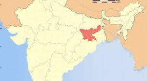
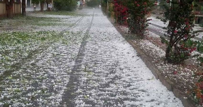
VIOLENT THUNDERSTORM, LIGHTNING STRIKES AND HAILSTORM LIKELY IN JHARKHAND, LIGHT SHOWERS IN WEST BENGAL

Source: skymetweather.com

After giving good rains in Central India, the Confluence Zone is expected to shift towards east, due to which scattered rains may commence in Jharkhand by today evening or night. The intensity is expected to increase gradually and many parts of the state may observe violent thunderstorm activities along with lightning strikes for next few days. The strong winds are expected to blow and there are also chances of isolated hailstorm activities until February 8.

Meanwhile, scattered light showers are likely in Gangetic West Bengal, wherein, Kolkata stands a chance to experience patchy showers on February 8 and 9. On the other hand, Sub-Himalayan West Bengal, as well as Central West Bengal, may remain dry.

Due to the presence of an Anti-Cyclone over the Bay of Bengal, humid winds from the southeast direction are blowing over East India. These winds are meeting with cold winds from the northwest leading to the formation of a Confluence Zone.

This convergence has led to the development of convective clouds that are capable of giving rain, thundershowers and lightning strikes. The Confluence Zone which has formed over Jharkhand is gradually expected to extend up to Gangetic West Bengal leading to rain.

India: Jharkhand On Shaky Ground – Analysis.

Source – eurasiareview.com

On October 19, 2019, Communist Party of India-Maoist (CPI-Maoist) cadres shot dead a couple in Khunti District. According to the Police, the rebels shot dead Sheetal Munda (50) and his wife Made Munda (45) at Aada village under the Saiko Police Station of the District, branding them ‘police informers’. Sheetal Munda was the deputy Sarpanch (head of the Panchayat, village level local self-Government institution).

On August 4, 2019, two youths were shot dead by CPI-Maoist cadres in Badani village under Arki Police Station limits in Khunti District. The Maoists alleged through pamphlets that they were ‘police informers.’

These were the four civilian fatalities recorded in the District in the current year so far (data till October 27, 2019). According to partial data compiled by the South Asia Terrorism Portal (SATP), since September 12, 2007, when the Khunti District was carved out of Ranchi, the former has accounted for at least 73 civilian fatalities as a result of Naxalite [Left Wing Extremist, LWE]-linked violence. However, when Khunti was a part of Ranchi District, it had recorded at least four civilian fatalities in LWE-linked violence, since March 6, 2000, when SATP started compiling data.

Khunti is one among 26 districts of 56 affected, spread across eight states, that has witnessed more fatalities in civilian categories than in the Security Force, SF, or Maoists categories. According to SATP, since September 12, 2007, Khunti has recorded a total of 152 fatalities [73 civilians, 17 SF personnel and 62 Naxalites (Left Wing Extremists)]. Significantly, out of the eight States, Jharkhand with (545 civilian fatalities) is also among the four that have registered more fatalities in the civilian categories than in the SF or Maoists categories. The other three are Bihar (209 civilian), Odisha (284), and West Bengal (483).

LWE-related Fatalities in Khunti District: 2007* -2019**

YearsIncident of FatalitiesCiviliansSFsLWEsTotal
20073 (21)3 (35)0 (1)2 (14)5 (50)
20084 (61)4 (61)6 (38)1 (61)11 (160)
20097 (101)5 (68)7 (71)4 (61)16 (200)
20107 (89)6 (73)0 (25)3 (45)9 (143)
201112 (79)11 (79)0 (29)9 (50)20 (158)
201210 (68)16 (49)2 (25)1 (29)19 (103)
20137 (55)4 (47)0 (26)10 (57)14 (130)
20148 (56)7 (49)1 (14)4 (39)12 (102)
20155 (33)1 (15)1 (5)5 (37)7 (57)
20167 (49)6 (34)0 (8)7 (40)13 (82)
201713 (82)5 (29)0 (4)4 (25)9 (58)
20182 (30)1 (17)0 (10)2 (26)3 (53)
20196 (29)4 (14)0 (9)10 (29)14 (52)
Total83 (706)73 (570)17 (265)62 (513)152 (1348)

However, the data suggests, civilian fatalities, which peaked at 16 in 2012, have recorded cyclical trends thereafter, but never reached double digits again, suggesting improvements in the security situation in the District, primarily as a result of increasing SF dominance on the ground.

Considering the overall fatalities in both the Maoist and SF categories since September 12, 2007, we find that the SFs have achieved an overall positive kill ratio of 1:3.64. More importantly, the SFs last lost a trooper on August 18, 2015, when a Policeman, identified as Dhumul Siwaiya, was killed in an encounter under Murhu Police Station limits in Khunti District. A CPI-Maoist ‘area commander’, Chandan aka Kalika Munda, was also killed in that encounter. Police recovered an AK-47 rifle and six loaded magazines from the encounter site.

Khunti is one of most backward regions of the State. Indeed, the NITI Aayog on March 28, 2018, launched the baseline ranking for ‘Aspirational Districts’ constructed on published data of 49 indicators (81 data points) across five developmental areas of Health and Nutrition, Education, Agriculture and Water Resources, Financial Inclusion and Skill Development, and Basic Infrastructure. Khunti is among the 115 identified backwards Districts, where the Government is committed to raising living standards, using a composite index of key data sets that included deprivation as enumerated under the Socio-Economic Caste Census, key health and education sector performance, and the state of basic infrastructure.

According to a September 19, 2019, report, Jharkhand Rural Development Minister Nilkanth Singh Munda claimed that Khunti has never seen development work as has been witnessed during the last five years. To give development a boost, Union Tribal Affairs Minister Arjun Munda noted that Khunti was one of the ‘aspirational’ districts of the country, and that “Development is taking place here rapidly. The government is working with the goal of making Khunti a developed district. ”

Khunti has an area of 2,535 square kilometers and shares its borders with Ranchi in the north and east; Saraikela-Kharsawan in the south-east, West Singhbhum in the south, and Simdega and Gumla in the West. All these Districts, with the exception of Saraikela-Kharsawan, are among the ‘30 worst Maoist-affected’ Districts, across seven States in the country, according to Union Ministry of Home Affairs (UMHA). Moreover, all these Districts are among the 90 districts in 11 States that are considered LWE affected, according to a Government release of February 5, 2019.

Several concerns persist in the District. Like in rest of Jharkhand, not only the CPI-Maoist, but several of its splinter groups operate in Khunti District. There are more than 12 such small breakaway groups, including the Peoples’ Liberation Front of India (PLFI), Jharkhand Liberation Tigers (JLT), and Jharkhand Sangharsh Morcha (JSM). These groups survive by extortion, arson, creating disturbances and even executing contract killings. According to Police, “These organisations collect illegal levy from coal traders, contractors and companies involved in coal mining, and indulge in arson and disturb coal transportation and other development works when not paid.”

An October 11, 2019, report, revealed that a squad of 20 rebels, including women, from Jhinkpani, Kuchai and Kharsawan were camping in the forest areas of Kuchai along the border with Khunti. Three suspected Maoists, identified as Maheswar Mahali, Ranjit Mahali and Shahani, had prepared the plan and were leading the squad. Intelligence reports suggested that there was a CPI-Maoist conspiracy to detonate explosives on a railway track and target the Howrah-Mumbai Gitanjali superfast train.

To fight the LWE menace, Central Reserve Police Force (CRPF), Indo-Tibetan Border Police (ITBP), Jharkhand Armed Police (JAP), and a special task force, the Jharkhand Jaguar (JJ), have been deployed in all the LWE-affected District of Jharkhand. A September 30, 2018, report, suggested that more than 2,000 paramilitary forces were deployed in Khunti.

According to the latest data provided by the Bureau of Police Research and Development (BPR&D), Jharkhand had a police-population ratio (policemen per hundred thousand population), as on January 1, 2017, of 174.96, significantly lower than the sanctioned strength of 229.19, though much higher than the national average of 150.75. The ratio was 167.92 per 100,000 on January 1, 2016. On January 1, 2005, the police-population ratio of the State was 160.5, again, much higher than the then national average of 140.4.

The LWE insurgency in Jharkhand in general, and in the Khunti District in particular, has been substantially degraded and criminalized, with extortion operating as the primary driver for the many splinter formations. Sustained SF pressure, combined with aggressive development, particularly of infrastructure and communications, is necessary to facilitate processes that would bring these residual problems to an end.

Bihar: Land of Rich Cultural Heritage

Source- hindustantimes.com

Geography

Bihar has hot summers and cool winters. It has a vast stretch of fertile plain drained by the River Ganga, including its northern tributaries Gandak, Koshi and Bagmati that regularly flood parts of the plains. Other rivers in the state are Falgu, Ghaghra, Durgawati, Sone, Punpun, and Karmanasa. Central parts of Bihar have some small hills, for example the Rajgir hills near the city of Rajgir.

Language

Hindi is the official language of the state, while Urdu is the second official language in 15 districts of the state. Maithili (including its dialect Bajjika), Bhojpuri, Angika and Magadhi are also widely spoken in this state.

Culture

Madhubani art, a form of painting that is world famous, is practised in the Mithila region of the state. Maithili music too orginates from the same region. The classical music in Bihar is a form of the Hindustani classical music. Gaya is another centre of excellence in classical music, particularly of the Tappa and Thumri styles. The Bihari thali consists of rice, roti, pickle, chutney, lentils and milk products. Llitti Chokha is a popular fast food.

Chatth Puja Almost all civilisations worship the ‘sun god’, but it has a unique form in Bihar. Chatth Puja is the only occasion where the setting sun is worshipped. For this four-day festival, people maintain sanctity and purity from even a month ahead.

Plant and animal life

Banyan, peepal, and palmyra palm trees are found in abundance. The forest regions are home to species of large mammals like Bengal tigers, leopards and elephants. Crocodiles are abundant along the Kosi river.

landmarks

Mahabodhi Temple, Takht Sri Patna Sahib, Nalanda University ruins, Vishwa Shanti Stupa, Rajgir, Golghar, Vikramshila ruins.

Famous people

India’s first President Rajendra Prasad, shehnai maestro and Bharat Ratna Bismillah Khan, social reformer Jayapraksh Narayan, poet Ramdhari Singh ‘Dinkar’, politician Jagjivan Ram, and actors Manoj Bajpayee and Shatrughan Sinha.

Railway stations and airports

Main railway stations are Patna, Gaya, Muzaffarpur, Hajipur, Barauni, Samastipur, Chappra, Darbhanga. Airports are in Patna and Gaya.

Major cities

Arrah, Aurangabad, Bagusarai, Bhagalpur, Bihar Sharif, Chappra, Darbhanga, Dehri, Gaya, Jehanabad, Katihar, Motihari, Patna, Purnia and Siwan.

Ajay River

Ajay River-Bihar
About:
Ajay River originates from the hills of Munger in Bihar. It flows through the Deoghar District in Jharkhand, joining with the Pathra and Jainti (Jayanti) rivers and proceeds on its journey through Dumka district to West Bengal. It flows down the plateau fringe, marking the boundary between Bankura and Birbhum districts in West Bengal where it meets the Bhagirathi river at Katwa in Murshidabad.  

It originates on a small hill about 300 metres high, south west of Munger in Bihar. It then flows through Jharkhand and enters West Bengal at Simjuri, near Chittaranjan. It first forms the border between Bardhaman District and Jharkhand and then between Bardhaman District and Birbhum District, and finally, it enters Katwa subdivision of Bardhaman district at Nareng village in Ketugram police station. It then joins the Bhagirathi River at Katwa Town. Total length of the Ajay is 288 km, out of which 152 km is in West Bengal.

The catchment area of Ajay River is 6,000 sq km. The important tributaries of the Ajay are Pathro and Jayanti in Jharkhand and Tumuni and Kunur in Bardhaman district of West Bengal. The upper reaches of the Ajay pass through hilly regions with latté rite soil. It is only from Ausgram in Bardhaman district that the Ajay flows through alluvial plains. The Ajay valley was densely forested with sal, piyasal and palas trees till recent times when mining and other activities led to the clearing of forests.The upper reaches of the Ajay pass through hilly regions with latté rite soil. It is only from Ausgram in Bardhaman district that the Ajay flows through alluvial plains. The Ajay valley was densely forested with sal, piyasal and palas trees till recent times when mining and other activities led to the clearing of forests
Location info:
Address:Ajay River, Munger,Bihar,Gujarat,India
District:Munger
Nearest City: Saharsa
Best time to visit: December to January
Climate/Weather:
Winter the lowest temperatures being 5 to 10 degrees Celsius. Winter months are December and January. It is hot in the summer from 40 to 45 degrees Celsius. April to mid June are the hot months. The monsoon months of June, July, August, and September see good rainfall. October & November and February & March have pleasant climate. 
History:
In the history of ancient India edited by Mc Krindle, there was a river called Amystis that flows past a town called Katadupa, in the days of Megasthenes. Another historian Wilfred opines that Amystis is modern day Ajay. In recent times there has been exploration of the remains of an ancient civilisation similar to that of the Indus Valley Civilisation at Pandu Rajar Dhibi in the lower Ajay valley.There has been at least 14 recorded floods in the 20th century in the Ajay river. The lower reaches of the river have embankments to prevent flooding.  
Interesting things to do:
 
Interesting things to Visit:
Bihar School of Yoga:
Bihar School of Yoga houses a Yoga Research Library. Comprising of a well-stocked and large collection of books and data, the library is an asset in itself. Here, you will find the school’s publication on Yoga, health techniques and research, apart from other books on yoga. The school, located at Ganga Darshan, is built over a large hill overlooking the Utter-Vahini Ganga. The location of the training is very apt, as it provides the perfect ambience for the establishment of such a training centre.  


Bhimbandh Wild Life Sanctuary:
Occupying an area of about 682 sq km, Bhimbandh Wildlife Sanctuary is located in the south-west of Munger District of Bihar. The sanctuary falls to the south of the river Ganges and is at a distance of 56 km from Munger. Besides being famous for its wildlife, the place is also well accounted for its hot water springs. These hot springs are basically found at the valley portion and the foothills of Bhimbandh.

Kharagpur Hills:
Kharagpur, in Munger District of Bihar, is a beautiful town at the foot of Kharagpur Hills. The main attraction of the town is the Ucheshwar Nath, a temple devoted to Lord Shiva. Kharagpur Lake, a large reservoir constructed by the Maharaja of Darbhanga, is just 3 km downtown. Malnipahar and Maruk hills are other spots worth visiting.
Mobile range info:
 
How to reach?
Nearest Railway Station:Bhagalpur Junction Railway Station
Nearest Airport: Patna Airport
Road Transport:National Highway numbers 2, 23, 28, 30, 31 and 33 make Bihar accessible by road too.
Nearest Visiting places:
Bodhi Tree:
This tree is worshipped as holy, divine and as a giver of enlightenment and wisdom. It is under this banyan tree (a pipal tree) that Lord Buddha meditated after renouncing all worldly pleasures and attained wisdom and divine enlightenment.The present Bodhi Tree is probably the fifth succession of the original tree under which the Buddha had attained enlightenment. Vajrasana (the posture in which he meditated), the seat of stability, is a stone platform on which the Buddha is supposed to have sat in meditation gazing east, under the Bodhi tree.  

Mahabodhi Temple:
Buddhism is today a world renowned religion. It is this temple that witnessed the divine enlightenment of Gautama Siddartha who renounced all worldly pleasures to find the answers to the questions that stirred his soul. He meditated under a pipal tree here and attained insight and wisdom that he preached to the world. This tree is also referred to as the “Bodhi tree”. A visit to this holy place will explain to you why the UNESCO declared it as a World heritage site in the year 2002.The Mahabodhi Temple, Bodhgaya built around 6th-7th centuries, is the largest but is a later structure constructed on the site of the Bodhi Shrine of Buddha. This temple was constructed by the famous Emperor Asoka who embraced Buddhism after feeling guilty of leading a life of war and destruction.
The temple is 170 ft high consisting of nine storeys of pyramidal towers. The structure has a stupa shaped dome at the top. At the base of the main tower are four towers at each of the four corners. On the edifice are several niches with Buddha images depicting scenes from his life. As you enter the temple you can see the main shrine which is built where Buddha attained Enlightenment. The place is called “the Navel of the Earth” (puthavinabhim) where Buddha gained wisdom, knowledge and light and later experienced this joy of liberation for the next seven days sitting there.

TARA STHAN:
It is situated at a distance of about 16 Kms west of Saharsa in village Mahishi where an ancient temple of Bhagwati Tara is built. The idol of Bhagwati Tara is said to be very old and draws devotees from far and wide. On either side of the main deity, there are two smaller female deities which are worshipped by the people as Ekjata nad Nil Saraswati.

Chandika Sthan at BIRATPUR: 
Biratpur village under Sonebarsa block of this district is famous for an ancient temple of goddess Chandi. This village is also associated with King Birat of the Mahabharat age. During exile the Pandavas had lived here for 12 years.The tantric Scholars and devotees attach much significance to this Chandi temple, which is said to form an equilateral triangle (TRIK) WITH Katyayani temple near Dhamhara ghat and Tara temple at Mahishi. During the Navratra people from distant places visit the village to offer prayers to the goddess of power.

Madan Bharti Asthan: 
The place is situated in Mahishi Block. It is said that a religious discourse (Shastrath) was held between Shankaracharya and the local scholar Mandan Mishra. Bharti, wife of Madan Mishra, who was also a great scholar, was named as Judge for the discourse. It is also said that Shankaracharya, after his initial victory over Madan Mishra was challenged by Bharati, was outwitted by her and he (accepted defeat).

SUN Temple at Kandaha: 
Like Deb (in Aurangabad district), the SUN Temple at Kandaha village is an important religious and historical place which has been duly recognized by the Archaeological Survey of India. The idol of sun god riding seven horsed chariot, has been carved on a single granite slab. At the door of the sanctum sanctorum, there are inscriptions which a deciphered by historians, confirm that this sun temple was built during the period of king Narsimha Deo of Karnata dynasty who ruled over Mithila in the 12th century. It is said that a brutal Mughal emperor named Kalapahad had damaged the temple which was however renovated by the famous saint poet Laxminath Gosai.

Laxminath Gosai Sthal at Bangoan: 
The famous saint and poet of which is hardly 9 Km away from the district head quarter. The huge bunyan tree under which the remains of Gosaiji have been preserved is the centre of great reverence for the people of the district.

Dewan Ban Mandir: 
One Shiv Ling is established in the temple situated in Sahpur-Manjhoul of Nauhatta block. It is said that the Ling was established by Maharaja Shalivahan some time in 100BC. The Hindus celebrate a festival called jitiya after the name of Jimutbahan who was the son of Maharaja Shalivahan. Description of this place is found in Shri Puran. The ancient shrine at Dewan Ban was washed away by the turbulent Koshi river. The local people have however build another temple in the adjacent area.

Nauhatta: 
It is an old village, important since the time of Mughals and is presently the head quarters of the block of the same name. The village has a ‘Shiva temple’ about 80 feet in height. The temple which was damaged in the earthquake of 1934 was reconstructed by Raja Srinand Singh of Srinagar Estate. There is a grave of Madho Singh on an earthen mound about 50 feet high. Madho Singh had become a martyr in the battle of Ladri Ghat. Offerings are made on he rave both by Hindus and Muslims.

Glacier lakes:
At present, in the Himalayan region, glaciers are melting and retreating resulting in formation of lakes insecurely dammed by ice or moraines. These dams are at risk of failing, causing a Glacial Lake Outburst Flood (GLOF) with flows as great as 10,000 cubic meters a second. Such floods are likely to destroy communication systems and various infrastructures like bridges roads, hydropower projects (directly or indirectly), foot trails, villages, fields and terraces, irrigation canals, and could cost hundreds or even thousands of lives. Such floods also transport huge amounts of sediment.  
In the past two decades GLOF has become a topic of intense discussion within the development community in Nepal. Studies of the glaciers and glacier lakes were carried out in 1988 by a joint Sino-Nepalese team. In the Arun-Koshi river basin, there are 737 glaciers in Tibet and 229 glacier lakes, out of which 24 glacier lakes are potentially dangerous. Similarly, there are 45 glacier lakes in the Sun-Koshi basin, out of which 10 are potentially dangerous.

Koshi Tappu Wildlife:
Koshi Tappu Wildlife reserve is a wetland situated in the flood plains of the Sapta-Koshi River in Nepal’s Eastern Terai. Gazette-notified as a wild life reserve in 1976, it covers a reserve area of 175 km2 (68 sq mi) and is one of the Outstanding Important Bird Areas in the Indo-Gangetic grasslands. The park has large population of Swamp Francolin, breeding Bristled Grass-warbler, records of White-throated Bushchat and Finn’s Weaver.[10] The Koshi river forms the major landmark of the reserve and is home to 80 fish species, around 441 species of birds, 30 shore birds, 114 water birds, 20 ducks and 2 ibises. The endangered swamp partridge and Bengal florican are also found here. The Koshi Barrage is an extremely important resting-place for migratory birds (87 nos winter visitors). In view of its rich biodiversity it was declared a Ramsar site of international significance in 1987.[11] The endangered Gharial crocodile and Gangetic dolphin locally known as sons in Bihar and a further endangered species (freshwater dolphin) have been recorded in the river.

Sagarmatha National park:
Sagarmatha National park is located in eastern Nepal, including parts of the Himalayas and the southern half of Mount Everest. The park, which is also included as a UNESCO world heritage site, was created on 19 July 1976. Sagarmatha in Sanskrit means “Forhead of Universe” (Sagar: Sky or Heavens; Matha: Forhead) and is the modern Nepali name for Mount Everest. The park covers an area of 1,148 km2 (443 sq mi) and ranges in elevation from its lowest point of 2,845 m (9,330 ft) at Jorsalle to 8,848 m (29,030 ft) at the summit of Mount Everest (highest peak in the world).[8] Other peaks above 6,000 m (20,000 ft) are Lhotse, Cho-Oyu, Thamserku, Nuptse, Amadablam, and Pumori. The upper watershed of the Dudh Koshi river basin system lies in the park. The types of plants and animals that are found in the park depend on the altitude.

Basin:
From Katmandu, there is a road for some distance followed by trekking paths to Mt Everest, which crosses four major tributaries of the Koshi. Namche Bazar near Tibet border in Nepal (near southern base camp of Mt Everest) is the major tourist centre in the mountainous part of the Koshi belt. Birātnagar in Nepal, and Purnia and Katihār in India are major cities on the Koshi Plains. Kamlā, Bāghmati (Kareh) and Budhi Gandak are major tributaries of Koshi in India, besides minor tributaries like Bhutahi Balān.
Legend:
Formerly Kauśiki (named after sage Viśvāmitra because Viśvāmitra is said to have attained the status of Vedic ṛṣi or Rishi on its banks; Viśvāmitra was descendant of sage Kuśika and was called Kauśika in Rgveda), in Nepal and Bihar in northern India is a major tributary of the Ganges (one major tributary of the Koshi is the Arun, a major part of whose course is in Tibet).
This river is mentioned in the epic Mahabharata as Kauśiki. Seven Koshis join together to form the Saptakoshi River/Sapt Koshi which is popularly known as the Koshi.It is also the lifeline of the Mithila region, today spread over more than half of India’s state of Bihar, and parts of adjoining Nepal and it forms the basis of legend and folklore of the region; the legend of Mithila extends over many centuries. Mithila is also the name of a style of Hindu art created in the Mithila area.
Nearest Petrol Pump:
Petrol Pump:Bhagalpur,Bihar,India  
Petrol Pump:Bhagalpur,Bihar,India
Hotels/Lodge/Accommodation:
Anand Hotel:Sabzi Market,Saharsa,Bihar,India  
Satkar Hotel:Saharsa,Bihar,India
Sana Rest House:Saharsa,Bihar,India
Things to carry:
 
Tips & Suggestions:
 
Help Line/Phone Number:
Police Station:100
Nearest Hospital:
Sadar Hospital:Khagaria,Bihar,India
Sadar Hosiptal:Begusarai,Bihar,India
Refinery Township Hospital:Begusarai,Bihar,India
Society/Community Phone Number:
Link:www.en.wikipedia.org