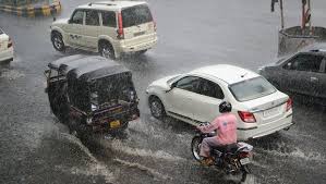
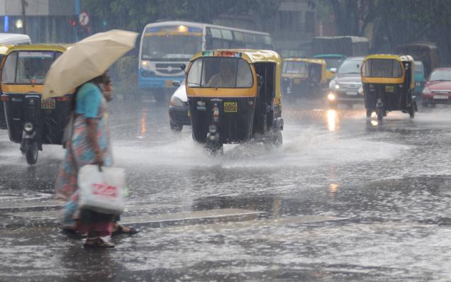
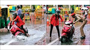
BEWARE OF THE WATER: 17 killed by lightning in Bihar, flood-like situation in several parts of the state

Source: dnaindia.com

At least 17 people, including men and children, were killed in incidents of lightning strikes in different parts of Bihar in the last 24 hours. Four deaths were reported in Kaimur district, four in Gaya, one in Katihar, three in Motihari, one in Ara and two each in Jahanabad and Arwal.

In Kaimur, a woman and a child died due to lightning strike. In Gaya district, one person died due to lightning strike in Tankuppa block and two lost their lives in Imamganj block. In Katihar, a person identified as Bhumeshwar Yadav died due to lightning strike. Sources told Zee Media that Yadav, a resident of Sukhay village, was struck by lightning when he was working in his field. 

In Motihari, three people, including two girls, died due to lightning strike, while a young person lost his life in Ara. In Jahanabad, one person died in Jaffarganj, while one death was reported from Meerganj village in Ratni bloc.

Meanwhile, several parts of Bihar is witnessing a flood-like situation due to overflowing rivers caused by incessant rainfall. In Patna, the water level of River Ganga rose 55 cm above the danger mark at Gandhi Ghat. The capital city experienced torrential rains for five-straight hours, causing water logging in Adalat Ganj, Kankarbagh, Sri Krishna Puri, Pataliputra and Rajendra Nagar.

The Central Water Commission (CWC) on Wednesday issued a flood alert for all the districts in Bihar along the course of Ganga from Buxar to Bhagalpur and said that the situation along the course of the rivers should be monitored closely.

Here comes the heavy rain in Jharkhand

Source: telegraphindia.com

Several parts of the state, especially those in its southern, central and western regions, are expected to experience heavy to very heavy rainfall in the next 24 hours, courtesy a depression over the Bay of Bengal.

Both the Ranchi and Calcutta centres of the India Meteorological Department (IMD) on Tuesday issued downpour alerts in their bulletins.

“The low-pressure area that was hovering over the north Bay of Bengal has intensified into a depression and lay centred around 160km southeast of Balasore (Odisha) and about 130km south-east of Digha (Bengal). Under its influence, several parts of Jharkhand will get heavy rainfall in the next 24 hours,” said R.S. Sharma, a senior Met scientist at the IMD’s Ranchi centre.

He said the depression would intensify into a deep depression as it moved north-westwards across Odisha and Bengal coasts over the next 48 hours.

“We believe the depression will result in heavy to very heavy rainfall in several places across the state in the next 24 hours,” he added.

The monsoon trough was on Tuesday passing through Ganganagar, Hissar, Mainpuri, Mirzapur, Ranchi, Jamshedpur and northwest Bay of Bengal, extending up to 1.5km above mean sea level.

Weathermen in Calcutta also predicted heavy and widespread rainfall.

“The depression is expected to weaken only after the next 48 hours,” said a duty officer, adding that several districts of Jharkhand were expected to experience a good spell of showers.

The showers during the next two days would help in reducing the monsoon deficit, which on Tuesday was at 40 per cent. Met data show that the state has received 352.5mm of rainfall so far against an average normal of 587.5mm.

The depression build-up coupled with an active monsoon trough gifted Jamshedpur a rainy Tuesday.

Weathermen said around 50 per cent Met stations in southern and central Jharkhand reported showers on Tuesday.

At some places the rainfall was accompanied by winds at 15kmph.

The local Met observatory in Jamshedpur recorded around 20mm of rain while several places in Ranchi and its outskirts recorded rainfall of around 5mm from 8.30am on Monday to 8.30am on Tuesday. Simdega recorded 70mm while Dhanbad experienced 40mm of rain. Palamau district headquarters Daltonganj recorded 30mm of rain while Chakradharpur, Chaibasa (both in West Singhbhum), Ramgarh, Chandil (in Seraikela-Kharsawan) and Ghatshila (in East Singhbhum) witnessed 10mm of rain each.

Death Toll in Assam, Bihar Floods Reaches 198

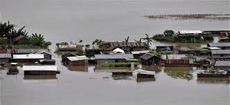
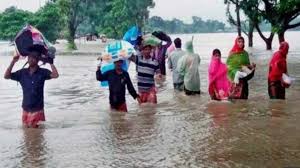
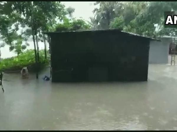
Source: thewire.in

New Delhi: The death toll in Bihar and Assam floods mounted to 198 on Thursday, with more than 1.17 crore people affected by the calamity in the two states, officials said.

In Assam, the death toll climbed to 75 with one more person succumbing in Dhubri, while water level rose in seven districts of the state.

Due to release of excess water from Kuricchu Hydropower reservoirs in Bhutan’s Kuricchu River, western Assam districts of Barpeta, Nalbari, Baksa, Chirang, Kokrajhar, Dhubri and South Salmara are facing rise in flood water level.

According to the Assam State Disaster Management (ASDMA), 34,92,734 people in 2,753 villages in 18 districts are affected by the deluge.

Flood water entered Bihar’s West Champaran, taking the total number of deluge-hit districts in the state to 13 on Thursday. But with no fresh deaths reported, the toll remained unchanged at 123, officials said.

West Champaran was inundated following torrential rains in the past few days, they said.

The Bihar Disaster Management Department said 82.12 lakh people under 1,241 panchayats of 106 blocks in the 13 districts were affected by the flood, and relief and rehabilitation work was going on in full swing.

An ex gratia of Rs 4 lakh was provided to the next of the kin of each deceased, while every family surviving the calamity was being given Rs 6,000 through direct benefit transfer.

Above-average rainfall predicted

The Indian Meteorological department, meanwhile, has predicted above-average rainfall over the next two weeks across the country. Despite floods in the northeast and Bihar, the country has received below average rains in the past two weeks.

However, on Thursday a weather department official told Reuters that there would be above-average rainfall, which would help summer-sown crops that were wilting in some areas due to a dry spell. Monsoon rains are crucial for farm output and economic growth as about 55% of India’s arable land relies on rainfall and agriculture forms about 15% of a $2.5 trillion economy.

“In the next two weeks, we are likely to get above average rainfall, which will be well distributed across the country,” said A.K. Srivastava, head of the climate research division at India Meteorological Department.

India’s monsoon rains were 35% below average in the week ending July 24, after receiving 20% less rainfall in the prior week, raising concerns over the output of summer-sown crops.

Overall, India has received 17% less rain than average since the monsoon season began on June 1, but in some states such as Gujarat, the biggest producer of cotton and groundnut, the rainfall deficit is as high as 42%.

Situation in Bihar to worsen after heavy rainfall in Nepal

Source: indiatoday.in

The flood situation in Bihar remained grim on Wednesday and is expected to worsen as neighbouring Nepal is witnessing heavy rainfall and the water from the overflowing rivers there may flow in to Bihar, an official said.

So far, 106 people have died while over eight million have been affected by the floods in Bihar. Thousands have been displaced across the state’s 12 districts as rivers are flowing above the danger mark at several places, officials said.

An official from the Water Resources Department said that heavy rainfall in Nepal since Monday is bound to worsen the situation in Bihar.

Latest reports suggest that the water level in major rivers is continuing to rise and embankments have been breached at several places. Water is also spreading to new areas, forcing people to take shelter at safer places, officials said.

Bihar Water Resources Minister Sanjay Jha told the media that embankments were breached at several places due to heavy rainfall. “We are working to repair embankments,” he said.

Jha said the government is doing everything possible to help the flood victims.

According to Wednesday’s report on the website of the Disaster Management Department, more than eight million people living in 1,238 panchayats in 12 districts have been affected by the floods that were caused by heavy rain in north Bihar and the catchment areas of major rivers in neighbouring Nepal.

Taking serious note of the flood situation, Chief Minister Nitish Kumar has directed the airdropping of relief, particularly food packets, in the affected districts.

Opposition legislators have been raising the issue of the failure of the state government to protect embankments and to carry out adequate rescue and relief operations.

The Disaster Management Department said relief and rescue operations were continuing in the flood-affected areas. A total of 26 companies of the National Disaster Response Force, the State Disaster Response Force and the Seema Sashatra Bal have been deployed in the affected districts to carry out rescue operations.

Drought fear looms large in Jharkhand as 14 districts face 40% rainfall deficit

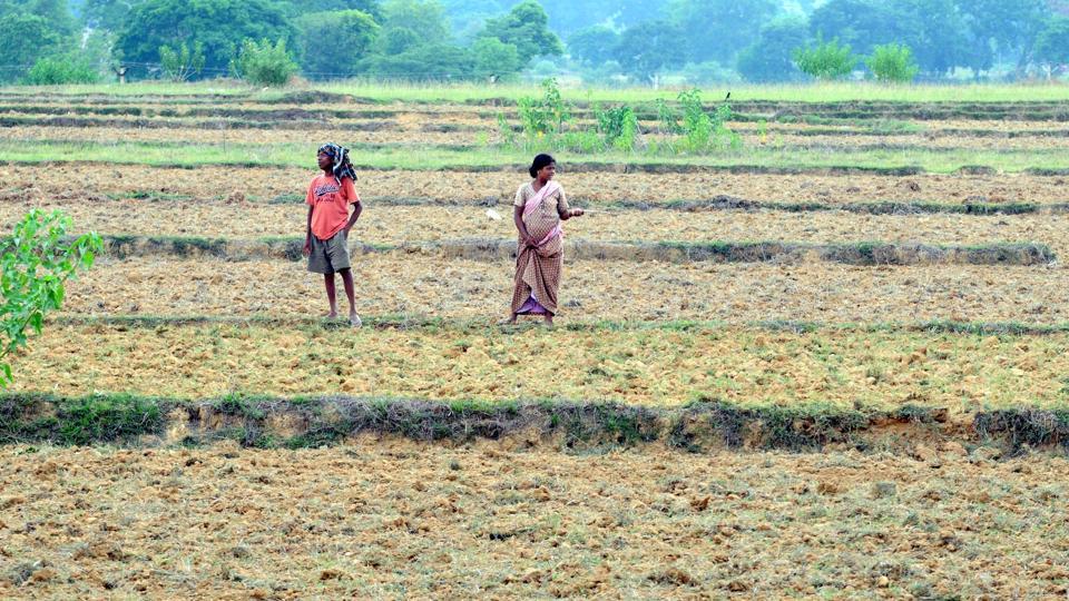
Source: hindustantimes.com

With monsoon rains skipping Jharkhand in peak kharif sowing season, drought cloud is looming large over the state as merely 10.58% paddy sowing coverage was achieved so far.

Paddy sowing is yet to take place in 13 out of 24 districts of the state due to rain deficit. Of the 11 districts where sowing has started, five districts have recorded less than one percentage sowing till Monday, according to district-wise kharif coverage data of the state agriculture department.

The coverage of other kharif crops is also not encouraging. Maize sowing coverage till date is 38.91%, pulses 12.76%, oil seeds 25.81% and coarse cereals 8.50%, according to the data.

In first week, the monsoon rainfall had raised hope of farmers, but it started weakening after July 12. Due to good rainfall till July 10, rainfall deficit recorded from 52% on July 1 to 30% on July 11. However, the weak monsoon for last five days has again increased the crisis as the rainfall deficit was recorded at 38% on Tuesday.

“Barring two districts Ranchi and Simdega, rainfall was nil in 22 districts in past 24 hours due to inactive monsoon,” said SD Kotal, director at Ranchi’s centre of Indian Meteorological Department (IMD). He, however, said monsoon became active over Jharkhand from Tuesday evening due to formation of a cyclonic circulation over Bay of Bengal

Light to moderate rainfall was expected in 50% area of Jharkhand mostly in parts of southern, north and northeast during next 24 hours, he said. “We are expecting good rainfall on Wednesday and Thursday due to the system, which would help improve rainfall deficit,” Kotal said. Jharkhand has received 227.4mm rainfall against the normal rainfall of 364.9mm, which means 38% deficit. Khunti district is facing highest 61% rain deficit, where the paddy sowing was recorded at 0.36% till Monday.

Out of 24, 14 districts have been facing over 40% rainfall deficit, which has largely impacted the paddy sowing activities.

An agriculture department official said the paddy sowing trend was almost similar to the previous year, which witnessed drought in 129 blocks out of 264. In 2018, sowing could not take place in 12 districts in the state till July 16.

Director research of Birsa Agricultural University (BAU), Dr DN Singh said that situation was grim.

“Farmers will have to change the pattern of paddy farming, as rainfall shortage has emerged as major trouble in state for last few years. Now, farmers will have to go for direct seeding instead of transplanting,” he said.

He said the ideal time for paddy sowing was July 15. “With delayed rainfall in monsoon season, the paddy sowing activity was extended to July 31. But, delayed sowing causes harvest loss due to age of the seed,” he said.

The state aims to sow paddy on 18 lakh hectares of land this kharif. However, BAU scientists find it a tough task due to delayed and deficit monsoon.

Rains in North Bengal, Bihar continue to wreak havoc

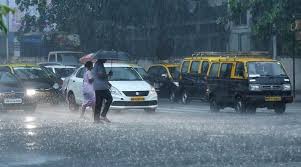
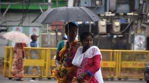
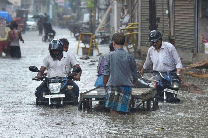
Source: timesnownews.com

Kolkata/Patna: Incessant rains in North Bengal and Bihar continue to wreak havoc with several areas in both the states reported to be inundated. However, what’s more worrying is the fact that the Indian Meteorological Department (IMD) has issued a warning of “heavy to very heavy” rainfall in both the states in the next couple of days. 

While sub-Himalayan districts of Darjeeling, Kalimpong, Jalpaiguri, Coochbehar and Alipurduar in West Bengal are bearing the brunt of these continuous rains, people living near the banks of Koshi, Gandak, Budhi Gandak, Ganga and Bagmati in Bihar have started to flee from their homes. 

According to the IMD, Northern Bihar received a record rainfall during the last 24 hours with East Champaran reporting 214.92 mm rain, Sitamarhi 154.55 mm and Muzaffarpur 125.15 mm. Whereas in West Bengal,  Alipurduars recorded 150 mm rainfall, followed by Coochbehar at 110 mm, Siliguri at 105 mm, Kalimpong 60 mm and Darjeeling at 30 mm in the same period. 

In West Bengal, a 40-year-old man Bimal Sil has reportedly died after slipping into an open gutter while walking through a flooded street in Jalpaiguri district. As per the state weatherman, Jalpaiguri, Malda, North Dinajpur, and South Dinajpur will receive heavy rain in the next couple of days.

Meanwhile in Bihar, given the rising level of water in rivers – all engineers in the north Bihar district have been directed to be ready with the necessary equipment and boulders to face any situation and protect the embankments – reported IANS

In 2008, lakhs of people were rendered homeless after Kosi river breached embankments and caused one of the worst floods in Bihar in the state’s history. 

As for the national capital, private weather forecasting agency has said that Delhi will receive below-normal rainfall this year. “The national capital may receive less than normal rainfall this year. The area may get light showers on July 15 and 16. Monsoon is likely to remain weak over Delhi, Punjab and Haryana,” vice president of Skymet Weather Mahesh Palwat said. 

Weak monsoon accounts for 30% rain deficit

Source: dailypioneer.com

The rain fall statistics released by the Meteorological Centre Ranchi on July 11 States that Jharkhand is facing a rain deficit of 30 per cent. From June 1 to July 11, the State has received a total of 218.2 mm of rain against the ideal amount of rain which should have been 310 mm.

“During the last week monsoon has been in an active phase in the entire state. In June the rain deficit in Jharkhand was recorded at 55 per cent and as of on July 11 it has come to 30 per cent showing an improvement of 25 per cent. In the next two weeks, it is expected that there are chances of further improvement in the rainfall statistics in the State,” said Senior Scientist, MET Observatory Centre- Ranchi, Dr. RS Sharma.

In the next few days normal rainfall activity is expected over northern parts of Jharkhand. However, in central and south Jharkhand there are not many chances of monsoon showers in the coming dew days. Thereafter another system is likely to form and monsoon might again be active.

“The monsoon trough is shifting towards the foothills of the Himalayas. Therefore from July 12 to July 15, reduced rain fall activity is likely to occur over Jharkhand and not all the stations but few places will receive light to moderate rainfall. However, the northern districts in the state will continue to receive rain,” the scientist further added.

Overall in Jharkhand, out of the 24 districts only five districts have received normal rainfall so far-Dumka, East Singhbhum, Lohardaga, Palamu and Sahibganj. The maximum deficit level- 59 percent was recorded at Pakur which has only received 148.3 mm of rain against the normal 358.5 mm. The State capital has a rain deficit of 35 percent and has received 214.1 mm of rain while the normal amount should be 331 mm.

As per the weather bulletin released by the MET Observatory Centre-Ranchi, on July 11, for the next four days July 12 to July 15, it is going to be cloudy in Ranchi and its surrounding areas.

The maximum temperature will be between 32- 34 degree Celsius while the minimum temperature will be 24 degree Celsius.

Jharkhand Witnesses 35% Rainfall Deficit

Source: weather.com

Jharkhand is witnessing a 35 per cent rainfall deficit in this monsoon season, a Met Department official said here on Monday.

“Jharkhand has received only 181 mm rainfall against the normal 276 mm till now. In the last two days, the rainfall has improved and it will continue for next 48 hours,” S.D Kothal, Director of the Ranchi Met Department, told IANS.

“But the rain will shift towards the Himalaya region from July 10 to 12. When it will retreat, state will then witness an improvement of the rainfall.”

The worst affected areas of the state are Godda and Pakur where rainfall shortage is more than 70 per cent. Garwah and Chatra have witnessed over 60 per cent deficiency.

Due to the shortage, paddy sowing has not gained momentum.

Jharkhand has not received normal rainfall in the last two years.

In 2018, the Jharkhand government had declared 129 blocks in 18 districts as drought-affected and released Rs 490 million for immediate relief.

As per the Met Department’s data, Jharkhand received 72 per cent average rainfall in 2018. However, in some places, it was less than 50 per cent. The worst affected were Pakur and Koderma.

The average rainfall in the state is 1,027.7 mm, but in 2018 it received only 741.9 mm.

Monsoon covers whole Bihar, many places receive good rainfall

Source: economictimes.indiatimes.com

PATNA: Several cities and towns in different parts of Bihar on Saturday received good rainfall as the monsoon covered the entire state, Met officials said.

The monsoon which hit Bihar’s north east districts on Friday, covered the entire state on Saturday, the Patna Meteorological Centre said.

Several cities and towns in different parts of the state received a good rainfall bringing down the temperature below normal maximum temperature.

Patna, like other cities, which have been facing the heatwave since the beginning of June this year, on Saturday witnessed a pleasant weather because of the first spell of good rainfall since the morning.

Patna received 33.0 mm of rainfall during the day between 8:30 am to 5:30 pm, bringing down maximum temperature down to 32.4 degrees Celsius which is three notches below normal, Met official said.

Gaya recorded a temperature of 33.0 degrees Celsius which is three degrees below normal maximum temperature, he said.

Bhagalpur and Purnea recorded maximum temperature of 36.0 degrees and 33.8 degrees respectively, Met official said, adding that Bhagalpur and Purnea recorded 3.2 mm and 0.3 mm rainfall respectively.

Met department forecast said that Patna is expected to witness generally cloudy sky on Sunday while Gaya, Bhagalpur and Purnea are expected to witness generally cloudy sky with possibility of rain or thunderstorm.

Onset of monsoon in Jharkhand likely by June 18

Source: hindustantimes.com

Jharkhand may expect the arrival of monsoon by June 18 as the southwest monsoon is likely to hit Kerala by June 8, weather officials said on Wednesday. Normal monsoon date for Jharkhand is June 10 and it should cover the state by June 15. However, it has never hit Jharkhand on the expected date since 2009.

The onset of monsoon in the state has been recorded between June 15 to June 25 in past one decade. In 2018, the southwest monsoon had hit Jharkhand on June 25, a delay of 15 days from its expected date, while it had hit Kerala on May 29, three days ahead of its normal date.

“Conditions are favourable for onset of monsoon in Kerala on Friday. If climatic conditions remain favourable with its current pattern, we may expect monsoon rain by June 17-18. However, it could be predicted only after it hits Kerala,” said SD Kotal, director of Ranchi Meteorological Centre. Even though the monsoon has been delayed by a week in India, a cyclonic circulation, which was over Jharkhand till Tuesday, brought relief from scorching heat across the state for last couple of days. Weather department said that excluding Palamu, maximum temperature was likely to get below 40 degree Celsius in most districts of the state.

The long-range forecast for monsoon, however, has worried farmers, as it has predicted 91% rainfall with possible deviation of 4% from June 1 to September 30 in northeast and eastern India.

“It’s a long-range forecast for the four-month monsoon, which may change after the onset,” Kotal said.

Farmers already faced drought in last kharif season due to deficient rainfall in last monsoon. In 2018, Jharkhand recorded 28% rainfall deficit during four-month monsoon period from June 1 to September 30, poorer than Bihar and West Bengal, which registered 25% and 20% deficit respectively.

The deficient rainfall impacted kharif crop in Jharkhand. The state government in November last year declared 129 blocks out of 264 blocks as drought affected. As many as 93 blocks were declared severely affected by drought due to poor sowing during rainy season last year.

Around 27% arable paddy land of the total target remained fallow. Of the 24 districts, sowing coverage could not reach 60% in seven districts even after the end of sowing season on August 15.

The centre released Rs 272 crore as drought relief to Jharkhand but the farmers are yet to get crop loss compensation. The poor monsoon had also impacted Rabi crops last year. Sowing coverage of Rabi crops was recorded in merely 7.58 hectares of land against the target of 11.69 lakh hectares this year.