Heavy rains inundate low-lying areas in Ranchi, Kolhan divisions

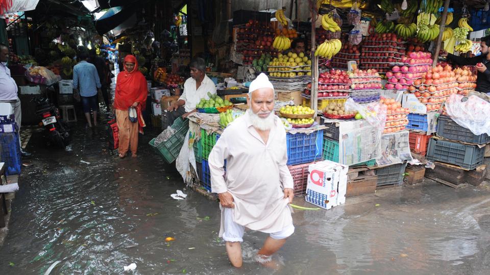
Source: hindustantimes.com

Heavy rains that lashed Jharkhand’s Ranchi and Kolhan divisions caused flood-like situation in low lying areas and disrupted the normal life on Sunday.

Incessant rains since Saturday night inundated parts of East Singhbhum, West Singhbum and Saraikela districts. Several families residing close to rivers in East Singhbum and West Singhbum districts were shifted to safe places.

With water level rising in rivers of West Singhbhum, water gushed in hundred of houses in Bandhgaon and Sonua areas in Chakradharpur sub-division of West Singhbhum.

Jamshedpur recorded season’s highest 146mm rainfall from 8.30am on Saturday to 8.30am on Sunday. Several low-lying localities such as Sonari, Kadma, Mango, Jugasalai and Bagbera suffered inundation as drain water gushed into localities.

Water logging on streets also affected the vehicular movement in Jamshedpur. In Adarsh Nagar of Jamshedpur, rainwater gushed in flats and residents of the colony remained stuck in their homes.

Officials in the Mango Notified Area Committee (MNAC) admitted the inundation due to lack of proper drainage system.

Ranchi also witnessed flood-like situation in several low lying localities, which forced residents to confine to their respective homes for long hours. Ranchi recorded the season’s highest rainfall 63.2mm rainfall.

The rainwater gushed in several shops in Ranchi’s Main Road. At Daily Market, shopkeepers suffered knee-level water. “Unscientific drainage system caused the water logging situation in the area,” said Md Parwez, a fruit seller at Daily Market.

Weather officials said situation in Kolhan division and Ranchi would improve from Monday.

“An intensified depression following a low pressure system in Bay of Bengal caused the rainfall in Jharkhand. The system moved towards westwards on Sunday afternoon. Now, the system is moving towards Chhattisgarh.

Rainfall is expected in western parts of Jharkhand in next 24 hours,” said SD Kotal, director at Ranchi meteorological centre.

The state faced rainfall deficit this year again with farmers demanding agricultural assistance from the Raghurbar Dars government.

The rainfall, however, reduced the deficit by three percent in 24 hours. The rainfall deficit, which was 34% on Saturday, came down to 31% on Sunday.

The state has received 482.5mm rainfall from June 1 to August 18 against the normal rainfall of 703.4 mm during the period.

The East Singhbum district, which suffered 24% rainfall deficit till Saturday, recorded 5% deficit on Sunday. Similarly, West Singhbhum’s rainfall deficit came down to 33% on Sunday from 40% on Saturday.

Communication gap: Bihar floods show why India, Nepal need to get their act together

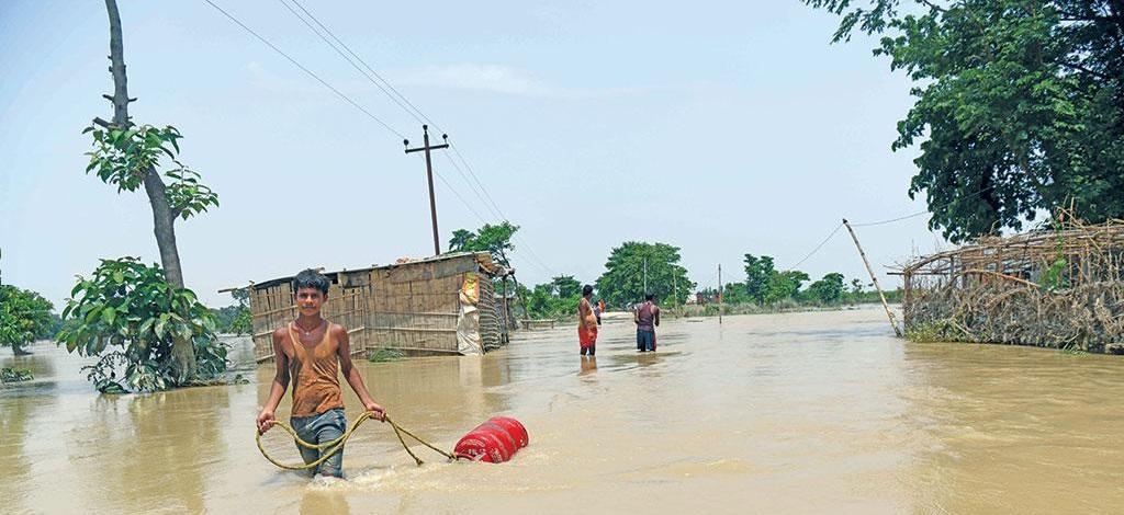
Source: downtoearth.org.in

Over 100 lives lost, 0.1 million displaced and 7.2 million people affected. That’s the human cost of the flood that deluged Bihar for close to two weeks this July.

Many lives could have been saved, losses averted, and people and livestock evacuated had the communities known beforehand that heavy rains were also lashing the Terai (lowland) region of the neighbouring Himalayan country, Nepal, and that the rivers flowing from across the border were in spate.

But weather-related information takes an average 48 hours to travel through the Indian and Nepalese bureaucratic circuit, say experts. And that’s way too long for a gushing river that can obliterate villages overnight.

Between July 7 and 13, heavy rainfall in Bihar caused flash floods in six districts. People started picking up their lives as the intensity of rainfall reduced by July 14.

But suddenly, the authorities of Koshi Barrage, located on the Kosi river just before it enters India, opened the floodgates. Though heavy rains in the state stopped by July 17, some 12 districts were declared flood-hit.

The delay of information sharing is alarming because every time Nepal has received heavy rains, Bihar has recorded flash floods. “In the recent past, this happened in 2008, 2011, 2013, 2015 and 2017,” says Narayan Gyawali of Lutheran World Relief (LWR) foundation, a non-profit that runs a community-based project in India and Nepal on early flood warning systems.

The two countries have a circuitous communication channel that means the information is either critically delayed or unclear, and of little use to most riverbank communities in down-stream Bihar. This is when the Nepal government has a dedicated Water and Energy Commission Secretariat for trans-boundary water issues, established way back in 1981.

Both the countries have also constituted a Joint Committee on Inundation and Flood Management.

Talking to Down To Earth, C K L Das, a member of the joint committee and chairperson of the Ganga Flood Control Commission, Patna, said the committee members do interact with communities that live in flood-prone areas in both the countries on a regular basis to assess their concerns and address those. But they do not issue flood warnings to communities as “there is no official requirement for us to do this”.

Just like Nepal, India too has a body, the Central Water Commission, which monitors floods in the country. But it looks only at the rivers and does not take into account the rainfall data for flood predictions.

“Though bringing together rainfall data and river monitoring to do better flood forecasting has been talked about by both the countries, there is no specific plan put in place for this to happen,” says Das.

Poor transborder information sharing has been a long standing problem for India. Last year, Arunachal Pradesh got flooded due to heavy rainfall in China. There are also fears that the ongoing rains in China might soon affect Assam, where 4.4 million people have already been affected by floods due to incessant rainfall.

“With the past political crisis during the Doklam standoff (the 2017 India China border standoff), the data sharing (between the two countries) has been limited,” says Giriraj Amarnath of the International Water Management Institute, a non-profit research organisation based in Colombo, which works on sustainable use of water and land resources.

While the government has failed to create a system to warn the people, several community-level initiatives across India and Nepal are seamlessly sharing timely information. The people of Bihar’s Birpur village in Supaul district, for example, received a flood warning on July 13.

“I got a call from Nepal about the rising water levels in the Kosi. We immediately shifted our families and livestock to safer zones,” says Chandan Roy from the village which is just a few kilometres from the Indo-Nepal border. The village was drowned a day later when Koshi barrage was opened.

“We had zero casualties because of the timely warning. We even communicated the information to nearby communities,” says Roy, who is part of LWR’s transborder citizen forum, an initiative started in 2013 where comm unities across the border regularly meet to discuss flood mitigation measures. The non-profit claims that the initiative issued timely warnings to 48 communities in India that benefitted over 25,000 people in Supaul and Madhubani districts.

“Community-based flood early warn ing system utilises local resources to enhance the community’s resilience,” says Neera Shrestha Pradhan of the International Centre for Integrated Mountain Development, which runs a similar initiative in the Hindu Kush Himalaya.

The upstream community generates the flood information using a low-cost transmitter-receiver unit and disseminates early warning to the communities. The transmitter is placed on the river bank, and the receiver is placed in a house of the nearest village.

The homeowner monitors the unit and disseminates information to communities, local government agencies, and other stakeholders through mobile messages and WhatsApp groups. 

Transborder information sharing is imperative because the frequency of extreme rainfall events is on the rise.

“Some of the most sophisticated forecasts with climate change models suggest that as the globe warms, more rains will fall in the form of severe, intermittent storms rather than in the kind of gentle soaking showers that can sustain crops,” says a report in the journal Nature. This trend was at play in July.

Till July 7, as many as 27 of the 38 districts in Bihar recorded over 40 per cent deficit rainfall. Over the next week, seven of these rainfall-deficit districts were under flash floods. Nepal too was waiting for the onset of monsoons till July 10, when its Department of Hydro logy and Meteorology issued a sudden warning of floods in the next 20-36 hours.

Over the next 24 hours, mid and eastern parts of Nepal received the heaviest rains in the past 30 years. The long term (1981-2010) precipitation data of Nepal highlights that Terai regions are becoming more prone to high-intensity rainfall events than the highland regions, according to a research paper published in the journal Climate in January 2017.

Given the climate pressures, Amarnath says India should bring an economic focus to its transborder flood warning policies.

“India allows Bhutan to use the Brahmaputra to ship goods to Bangladesh. Such economic associations help establish effective warning systems across international borders.” Political will along with community-driven initiatives is an effective way to prepare for such floods, he adds.

Deep depression weakens but heavy rains to stay

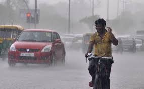
Source: thehindubusinessline.com

The deep depression over South Jharkhand had weakened into a depression on Thursday morning, but it shall hardly make a dent on its rain generating capacity.

The depression centred over north-east of Chhattisgarh this morning, about 90 km east-southeast of Ambikapur (Chhattisgarh) and about 140 km west-southwest of Ranchi (Jharkhand).

Heavy rain warning

India Met Department (IMD) has warned of strong winds with speed up to 40 km/her and gusting to 50 km/hr over interior areas of Odisha, Chhattisgarh and Jharkhand until Thursday night.

The depression may continue to move deeper into Central India and weaken gradually, but the IMD has given out a heavy to very heavy rain warning across a wide swathe of geography.

Widespread rainfall with isolated heavy to very heavy falls is likely over Odisha, Chhattisgarh, plains of Bengal, Bihar, Jharkhand, Vidarbha and northern Andhra Pradesh and Telangana until Friday.

A similar outlook is valid over Madhya Pradesh for the next two days; over Madhya Maharashtra, Konkan, Goa, Kerala and Karnataka for next three days; and over Gujarat on Friday and Saturday.

Isolated extremely heavy falls are likely over the ghat areas of Madhya Maharashtra, Konkan, Goa, Kerala, and coastal and southern interiors of Karnataka during next two days.

The same forecast is for South Madhya Pradesh and East Rajasthan for today and over Gujarat for tomorrow.

Kerala has declared a holiday today for all schools and colleges across seven of its 14 districts given the threat of continuing heavy rain, especially in the northern districts.

Kerala on red alert

A red alert has been declared over the dam-bound Idukki, Kozhikode and Malappuram districts. Storage levels in reservoirs owned by the State Electricity Board was at 27 per cent as of Wednesday.

In detailed forecasts, the IMD said that light to moderate rainfall is likely at most places over Odisha and Chhattisgarh with heavy to very heavy rainfall at a few places and isolated extremely heavy falls till tonight.

Heavy to very heavy rain may persist over Chhattisgarh till Friday. Moderate rainfall is likely at most places over East Madhya Pradesh with isolated heavy to very heavy and extremely heavy falls.

Light to moderate rainfall is likely at most places over North Andhra Pradesh, Telangana and Vidarbha until tomorrow with heavy to very heavy falls at a few places.

The subsequent onward movement of the depression will bring moderate rainfall over West Madhya Pradesh and East Rajasthan today with heavy to very heavy falls and isolated extremely heavy falls (above 20 cm).

Heavy to very heavy rainfall will persist at isolated places over West Madhya Pradesh and East Rajasthan until tomorrow. Moderate rainfall is likely over Gujarat tomorrow with heavy to very heavy and even isolated extremely heavy falls.

Bihar is flooding, but where did it start? Hint: look north

Source: downtoearth.org.in

You would expect floods to follow heavy rains, but the current flooding of north Bihar preceded extreme rainfall. The trigger for the deluge was the downpour in Nepal.

Bihar shares its northern border with the country, from which a slew of Himalayan rivers run down south. Rising water level in many of those wreaked havoc in 12 districts of north Bihar as floodwater breached embankments, snapped roads, washed away small bridges and damaged standing paddy, maize and jute crops.

On July 11-12, Nepal’s Simara weather station received more than half the 580.2 milimetre rainfall it gets in July normally. The spell totalled 478.40 mm by July 13. 

The next day Nepal opened all 56 sluice gates of the Kosi barrage, with water at alarming levels, releasing three lakh cusecs towards Bihar.

Heavy rainfall ensued in bihar as well, but the sudden rise of water levels in Kosi, Bagmati, Kamka Balan, Gandak, Budhi Gandak and their tributaries was due to an extreme weather event in Nepal, said Vyas, vice-chairman of Bihar State Disaster Management Authority (BSDMA).

The floods have affected more than 2.5 million people of 546 panchayats at 77 blocks in 12 districts, BSDMA officials said.

The state is not new to floods, but it was taken by surprise by the amount of rainfall it received this time and its timing. It usually rains heavily in the state during August, instead of July.

Bihar Chief Minister Nitish Kumar told the Assembly on July 16, 2019 that the state is “fully prepared to deal with” the flash floods. But, everyone else in the state — be it activists or people actually bearing the brunt — feel surprised and unprepared for the unprecedented amount of rainfall.

Everyone living in villages near embankments in Supaul district failed to understand why the water level in river Koshi rose so high in July itself, said Mahendra Yadav, an activist working with flood victims in Koshi region. “Even people in their mid-60s said they had not experienced such a phenomenon in their lifetime,” added Yadav.

North Bihar districts received record-high rainfall during between July 12 and 13, said India Meteorological Department (IMD) officials. East Champaran got 214.92 mm of rainfall, Sitamarhi 154.55 mm and Muzaffatpur 125.15 in those 24 hours. This surpassed a 54-years-old record of heavy rainfall in 24 hours in Bihar.

Then, on July 14, Kishanganj block alone recorded 186.8 mm rainfall within five hours followed by Kochadham block that got 164.2 mm, Thakurganj block 163 mm and Bagadurganj block 162 mm. “Intensity of heavy rainfall was not witnessed before. It caused swollen rivers,” said a disaster management official.

These floods are an example of how climate change would affect lives of people, particularly the poor, Ranjeev, another activist, told Down To Earth.

Now, water resources department officials said water levels in rivers originating in Nepal are decreasing since no heavy rainfall has been recorded in last two days.

Relief and rescue operations are on in flood-affected areas as 26 companies of National Disaster Response Force, State Disaster Response Force and Seema Sashatra Bal have been deployed. Also, 125 boats have been pressed into rescue works.

At Least 15 Killed Including 4 Children, Many Feared Trapped Under After Wall Collapses Due To Heavy Rains In Pune

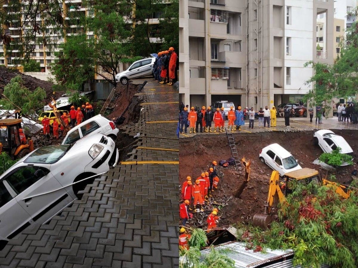
Source: indiatimes.com

15 people have been confirmed dead and many more are feared to be trapped under after a portion of a wall of a residential building in Pune, Maharashtra collapsed.

All the victims including four children and a woman were living in temporary shelters built for labourers working in a nearby construction site. The victims were natives of either Bihar or Uttar Pradesh.

According to the police, a portion of the 12 to 15-feet-high wall collapsed between 1.30 and 1.45 am crushing the victims under it.

Those injured have been shifted to a local hospital. Rescue teams including the NDRF are continuing their search for more possible survivors.

Police had earlier said that 17 people were killed in the incident.

Dramatic visuals from the spot also showed a number of cars also trapped under the debris.

According to officials, prima facie the reason behind the collapse of the wall was the heavy rains. However, an investigation has been launched into the mishap to look into all aspects including whether the shelters which were barely 40 feet away from the residential building’s wall was illegal.

“We have ordered an inquiry into the incident and those responsible will be punished,” District Collector Naval Kishore Ram who visited the spot said.

Pune like other parts of Maharashtra received heavy rains on Friday.

Over 73.1 millimetres of rain was recorded in the city in the past 24 hours, the second highest rainfall in June since 2010.