A plot for your house of 4 decimial in chira chas location at a
very reasonable rate. come, build and live at your own house.. invest in your
own relationship…… @ 240,000 lakh per decimial. OR take it as an investment
deal…. ItS your choice after all..
BOKARO: Taking a note of
a steep rise in incidents of land scams that dupe many people, Bokaro deputy
commissioner Uma Shanker Singh on Wednesday urged the residents to verify
land-related documents from the government office concerned before buying flats
or houses from builders and real estate agents.
TNN | Feb 20, 2014, 10.07AM IST
Singh made this appeal after a fresh case of land scam was
busted in an inquiry constituted by him. A builder launching housing project
named Golden City in Chas block has allegedly duped more than 100 people for a
sum of about Rs 3 crore. The company had purchased 71 acres of land, but sold a
chunk of more than 10 acres on the basis of fake documents.
After receiving complaints from the residents, Singh constituted an inquiry
headed by Chas circle officer Naresh Soni and special officer Krishna Kumar.
They found that the builder has fraudulently sold land to the residents showing
fake sale deed and agreements.
Singh said that a
notice was sent to the builders asking them to present documents before the
officials, but they failed to appear before the panel. However, when residents
started demanding their money back, the builder threatened them with dire
consequences.
The accused have been identified as Sushil Kumar Singh, Sunil Kumar, Sudhir
Kumar, Anil Kumar and five others. “Based on the report, I have directed
the officials to take strict legal action against the accused. We have also
asked the police to take necessary measures to ensure that those cheated by the
builder get their money back,” said Singh. He also urged the people of the
district to “verify land status before purchasing flats or bungalows from
builders or middlemen. Do not keep your eyes closed while buying houses as it
will make you suffer”
Bokaro has witnessed many lands scam cases in which builders first acquire
lands in an unauthorized manner and then sell it to residents. Singh also
warned builders to not to indulge in such unfair practices because they are not
being spared if caught someday. Rising population and rapid industrialization
has inflated land prices and boosted the real estate business here.
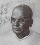
Jayaprakash Narayan was born on October 11, 1902, in Sitabdiara, a village on the border of Uttar Pradesh and Bihar. His father Harsudayal was a junior official in the canal department of the State government and was often touring the region. Jayaprakash, called Baul affectionately, was left with his grandmother to study in Sitabdiara. Since there was no high school in the village, Jayaprakash was sent to Patna to study in the Collegiate School While in school, Jayaprakash read magazines like Saraswati, Prabha and Pratap, books like Bharat- Bharati, and poems by Maithilsharan Gupta and Bharatendu Harishchandra which described the courage and valor of the Rajput kings. Jayaprakash also read the Bhagwad Gita. He excelled in school. His essay, “The present state of Hindi in Bihar” won the best essay award. He joined the Patna College on a Government scholarship.
Jayaprakash was married to Prabhavati, daughter of lawyer and nationalist Brij Kishore Prasad in October 1920. Prabhavati was very independent-minded and on Gandhiji’s invitation, went to stay at his ashram while Jayaprakash continued his studies.
Jayaprakash, along with some friends, went to listen to Maulana Abul Kalam Azad speak about the Non-cooperation movement launched by Gandhiji against the passing of the Rowlatt Act of 1919. The Maulana was a brilliant orator and his call to give up English education “like leaves before a storm, (Jayaprakash was) swept away and momentarily lifted up to the skies. That brief experience of soaring up with the winds of a great idea left imprints on (his) inner being.” Jayaprakash took the Maulana’s words to heart and left Patna College with just 20 days remaining for his examinations. He joined the Bihar Vidyapeeth, a college run by the Congress. After the Chauri Chaura incident in eastern Uttar Pradesh, the Non- cooperation movement was suspended. Most students returned to their colleges.
After exhausting the courses at the Vidyapeeth, Jayaprakash decided to go to America to pursue his studies. At age 20, Jayaprakash sailed aboard the cargo ship Janus while Prabhavati remained at Sabarmati. Jayaprakash reached California on October 8, 1922, and gained admission to Berkeley in January 1923. To pay for his education, Jayaprakash picked grapes, set them out to dry, packed fruits at a canning factory, washed dishes, worked as a mechanic at a garage and at a slaughter house, sold lotions and accepted teaching jobs. All these jobs gave Jayaprakash insight regarding the difficulties the working class faced.
Jayaprakash was forced to transfer to Iowa State when fees at Berkeley were doubled. He was forced to transfer to many universities thereafter. He pursued his favorite subject, Sociology and received much help from Professor Edward Ross, the father of Sociology.
In Wisconsin, Jayaprakash was introduced to Karl Marx’s “Das Capital”. News of the success of the Russian revolution of 1917 made Jayaprakash conclude that Marxism was the way to alleviate the suffering masses. He delved himself into books by Indian intellectual and Communist theoretician M.N. Roy. His paper on Sociology, “Social Variation”, was declared as the best of the year.
Jayaprakash had to cut his doctorate short when news came that his mother was seriously ill. Jayaprakash returned to India in November 1929, “a mature young man with an enquiring mind, original in his thinking, and with the fierce, idealistic desire to devote himself to serve society.” For Jayaprakash it was not enough that the nation attain political freedom. To him, the definition of freedom was freedom from hunger, poverty and ignorance.
While Jayaprakash became a believer of the Communist school of thought, Prabhavati became an ardent Gandhian. He respected Prabhavati’s choice and did not force her to change her views. In 1929, both Jayaprakash and Prabhavati left for the Congress session at Lahore under Jawaharlal Nehru’s presidentship. There Nehru invited Jayaprakash to join the Congress, an offer that Jayaprakash gladly accepted. He began work in the Labor Research Cell of the Congress at Allahabad.
Following the 1930 Dandi March, most of the top Congress leaders were arrested. Jayaprakash immediately set up an underground office at Bombay to continue Congress work. He traveled all over the nation, printing, distributing and organizing secret meetings. After an underground meeting of the Congress Working Committee in Banaras, Jayaprakash went to Madras where he was arrested. The next day the newspaper headlines screamed, “Congress Brain Arrested!”
In the Nasik jail, Jayaprakash had the opportunity to meet thinkers like Ram Manohar Lohia, Ashoka Mehta, Minoo Masani, P. Dantawala and Achyut Patwardhan. They all were impatient for freedom and agreed to steer the Congress toward the goal of socialism. Jayaprakash was released from jail in 1933.
In 1934, Jayaprakash and his friends formed the Congress Socialist Party under the Presidentship of Acharya Narendra Deva and secretaryship of Jayaprakash himself. The group intended to function as the Socialist wing within the Congress party and aimed to make socialism the goal of the Congress. In a book “Why Socialism?” (1932), Jayaprakash explained why socialism would be right for India. He was adored by the youth for his idealism.
Jayaprakash was arrested for speaking against Indian participation in the Second World War in February 1940 and sent to Deoli detention camp in Rajasthan. Jayaprakash was appalled at the conditions in Deoli. He organized a hunger strike to protest the conditions in 1941. The Government immediately released him. He was again arrested in 1942 for participating in the Quit India movement. In November 1942, Diwali night, Jayaprakash along with five others escaped the prison by scaling the 17 feet high wall while the guards remained distracted by the festivities. A Rs. 10,000 reward was offered for Jayaprakash’s capture, dead or alive. Jayaprakash escaped to Nepal and organized a guerilla army called the “Azad Dasta”. Jayaprakash and Ram Manohar Lohia were captured briefly but were rescued by the Azad Dasta members, who set fire to a hut to distract the guards. Both freedom fighters escaped to Bihar. Finally the British closed in on Jayaprakash in Amritsar when he was on his way to Rawalpindi to meet Khan Abdul Gaffar Khan. Jayaprakash was taken to Lahore Fort, notorious as a “Torture chamber” on September 18, 1943. 16 months of mental and physical torture followed. Jayaprakash was put in solitary confinement for the first month. Then came interrogations, physical torture and humiliation. Jayaprakash was released from jail on April 12, 1946.
Jayaprakash returned to a nation he could barely recognize. Talk of partition and riots between Hindu and Muslims dominated the atmosphere. Jayaprakash rushed to Bihar to assist in curbing the riots. He pleaded with the Congress Working Committee not to accept the partition plan.
Independence finally came on August 15, 1947. Within a year Gandhiji was assassinated. Prabhavati hid her sorrow behind the spinning wheel, but Jayaprakash’s mind “churned (with) grief and horror.” He began to see the wisdom in Gandhiji’s insistence on truth and non-violence.
The Socialists lost to the Congress in the 1952 elections. Nehru invited Jayaprakash to join the Cabinet. When Nehru could give no assurances on the implementation of Jayaprakash’s 14 point plan to reform the Constitution, the Administration and Judicial system, nationalize the banks, redistribute land to the landless, revive Swadeshi, and setup cooperatives, Jayaprakash refused the offer.
Jayaprakash turned his attention to the trade unions he was President of. He, along with the unions was able to get a minimum wage, pension, medical relief and housing subsidy introduced. At the same time, Jayaprakash was keenly watching events in Russia. The bloody purges and imprisonment convinced Jayaprakash that communism was not for India. He realized that Gandhiji’s success in the freedom struggle had showed that it was possible to bring about change without sacrificing one’s values.
On April 19, 1954, at a meeting in Gaya, Jayaprakash made the dramatic announcement of dedicating his life (jeewandaan) to Vinoba Bhave’s Sarvodaya movement. He renounced all self-interest, gave up his land in Sitabdiara, and withdrew from all personal activity to devote the rest of his life to the movement. Prabhavati was delighted at this declaration. Jayaprakash set up an ashram at Hazaribagh, a poor and backward village. He gave Gandhian concepts a new dimension by using modern technology to uplift the village.
Jayaprakash believed that every village should be like a small republic – politically independent and capable of taking its own ecisions. It was a marriage of Gandhian-Indian concepts and modern Western democracy. His thoughful, well-researched and brilliant book, “The Reconstruction of Indian Polity,” won him the Ramon Magsaysay Award.
In June 1971, Sarvodaya workers in Muzaffarpur, Bihar, received a letter threatening to kill them. The area was continuously threatened by Naxalites, which was made up of young men. Jayaprakash walked into the heart of Naxal territory armed only with love and sympathy. He knew that the cause of the violence was that the youth were frustrated because of poverty and unemployment. He lived in Musahari block for many months and experimented to alleviate the problems of the Naxals. Jayaprakash was also a key person in acquiring the surrender of dacoits in the Chambal Valley.
On April 15, 1973, Prabhavati died of cancer, leaving Jayaprakash alone.
1974 ushered in a year of high inflation, unemployment and lack of supplies and essential commodities. Jayaprakash was asked to lead a peaceful agitation by the Navanirman Andolan of Gujarat. On April 8, 1974, at the age of 72, he led a silent procession at Patna. The procession was lathi charged. On June 5, 1974, Jayaprakash addressed a mammoth crowd at Gandhi Maidan in Patna. He declared, “This is a revolution, friends! We are not here merely to see the Vidhan Sabha dissolved. That is only one milestone on our journey. But we have a long way to go… After 27 years of freedom, people of this country are wracked by hunger, rising prices, corruption… oppressed by every kind of injustice… it is a Total Revolution we want, nothing less!”
On June 12, 1975, the Allahabad High Court held the Prime Minister, Mrs. Indira Gandhi, guilty on charge of corrupt practices in the election. Jayaprakash advised her to resign until her name was cleared by the Supreme Court. Instead, she clamped Emergency on June 26. Jayaprakash was arrested and sent to Chandigarh where he was kept prisoner in a hospital. “My world lies in shambles around me,” he cried. As his health worsened, he was moved to a hospital in Bombay.
Finally in January 1977, Emergency was lifted. Fresh elections were declared. Under Jayaprakash’s guidance several parties united to form the Janata Party. The party incorporated all of Jayaprakash’s goals in its manifesto.
Jayaprakash was weak and helpless by that time. He felt his work was done, but he had to sorrowfully witness the collapse of the Janata Party government. Jayaprakash died on October 8, 1979. People hailed him as “Lok Nayak” or leader of the people. Vinoba Bhave said after Jayaprakash’s death that Jayaprakash considered himself only a “Lok-sevak,” or servant of the people.
Situated in the district of Daltonganj, Palamau Sanctuary is spread over an area of 979sq.km. The core area of 232 sq. kms of the sanctuary was declared as Betla National park in September1989. The park occupies the western parts of the Chotanagpur plateau and was constituted in the year 1960 as an extension of the Hazaribagh National park. Palamau has the distinction of being the forest where the world’s first tiger census was enumerated in 1932. The park became one of the earliest 9 tiger reserves in India under ‘Project Tiger’ in 1974.
The forests of the park have a vast range of vegetation consisting of tropical wet evergreen forests in the lower reaches, mixed (moist & dry) deciduous forests in the middle and temperate alpine forests in the upper reaches including Sal and bamboo as the major components along with a number of medicinal plants. The river Koel and its tributaries run through the northern portion of the park. There are grasslands in the river flowing area. It has waterfalls and hot springs too. Once the seat of Chero kings, there are two historical forts, one of them belonging to the 16th century deep inside the forest. The main sentinel of the old fort is visible high up on the hill with defences in three directions and three main gates.
The diversity of eco-system promotes a wide variety of fauna consisting of elephant, panther, leopard, wild boar, tiger, gaur, sloth bear, sambar, chital, nuntjac, nilgai, langur, mouse deer, monkeys, small Indian civet, mongoose, jackals, porcupine, ant eating pangolin etc. Elephants in large numbers are seen mostly during the monsoons up to the time when water sources begin to dry up in March. Jackal and hyena are common scavengers. Bird-life is rich featuring the hornbill, peafowl, red jungle fowl, black partridge, white necked stork, black ibis, swamp grey, quail, the pied born bill, wagtails, the harial, doves, drongo, the crested serpent-eagle, forest owls, the papiha and other birds usually found in dry deciduous forests. The famous Kamaldah lake attracts several varieties of water birds including the common whistling and cotton teal, the comb duck, snipe and geese. The rhesus monkey and the common languor provide attraction to children visiting the park.
Location
info:
Address:Daltonganj,Ranchi,Jarkhand,India
District: Daltonganj
Nearest City: Daltonganj
Best time to visit: October to May
Climate/Weather:
The
climate of this region is extreme with the maximum temperature going well
over 40°C in summers. In total contrast to this, winters are quite cold with
the minimum temperature dipping to 3°C. The monsoon months are from July to
mid September.
History:
Betla
national park is nestled in the lap of Deccan Plateau which includes 1,026
km² of Palamau Tiger Reserve in the state of Jharkhand. An additional 226 km²
was added to the park in 1989 and 63 km² of the Mahuadar wolf sanctuary was
added to national park.
Interesting
things to do:
Visit the historical monuments that the national park houses.
Purana Quila and Naya Quila are important attractions for tourists. Though
they are named the Old Fort and the New Fort, they seem to be built around
the same time.Enjoy stunning views from the watchtowers and the ground hides
that have been recently added to enhance the charm of wildlife spotting in
the park.Other attractions that one must visit here include waterfalls
and hot springs.Elephant rides into the jungle of Betla are a major draw for
tourists visiting here.
Interesting
things to Visit:
Fauna:
Large herds of Gaur and Chital are commonly seen. Elephants are present
mostly after the monsoons up to the time when water holes begin to dry up in
March. Tiger, Panther, Sloth Bear, Wild Bear, Sambhar, Nilgai, Kakar, Mouse
Deer are also permanent residents. Large families of langurs are an ever
present attraction. Palamu is now one of the nine Tiger Reserves in India
under Project Tiger
Mobile
range info:
How to
reach?
Nearest Railway Station:Daltonganj (25 km away) Railway Station
Nearest Airport:Ranchi, situated around 140 km away, is the airport with
regular air connections to Delhi, Calcutta, Patna and Lucknow.
Road Transport: Betla is well connected to Daltonganj (25 kms) via
Khudia morh (6km), Ranchi (140 kms), Hazaribagh (190 kms), Netarhat (211
kms), Patna (384 kms), Calcutta (575 kms) etc by regular buses run by the
state transport corporation and private companies.
Nearest
Visiting places:
Shahpur: Opposite Daltonganj on the west bank of the Koel is the village SHAHPUR in which Gopal Rai, the Raja of Palamu built a palace in the end of the 18th century. Shahpur stands on a high tract of land and the ruined place, the white temple and the masonry building present a picturesque view from Daltonganj. A nearer view of the palace is disappointing for what looks in the distance like an imposing edifice is seen to be half- finished building of little architectural importance.
Palamau: Palamau on the Auranga river , 20 miles south-east of Daltonganj as the crow flies, from which the district takes its name is for historian and archaeologist the most interesting place in the district, for it was for many years the seat of the Chero chiefs and it contains the ruins of the two great forts built by them, the capture of which by Mughals and later by the British resulted in the collapse of the Chero resistance, the forts lie within the reserved forests and in order to preserve them the jungle has to be cut back at intervals .they are a favourite haunt of tigers, whose pug marks may nearly always be seen in and around the fort.The walls which are in preservation are about 5 feet in thickness and those of the old fort bear marks of cannon balls and bullets in many places.
Netarhat: The plateau of Netarhat in Palamu district is comparatively unknown to the tourists from outside although it is one of the rare beauty spots which is capable of great development. About a century back, it is understood, there was a military camp at Netarhat. The camp had to close down because sufficient good water was not available. It was left to Sir Edward Gait, Lt. Governor of Bihar and Orissa to give a great Importance to the plateau. Sir Edward and after him many of the Bihar and Orissa and later Bihar Governors use to spend a part of the summer exodus at Netarhat . Netarhat although situated in Palamau District is more easily accessible from Ranchi, the summer head quarter of the Old Bihar Govt. it is at a distance of 96 miles from Ranchi, the last 12 miles of which commencing from Banari runs through the hilly section and is typical of any of the other hill stations. There is an excellent all weather road of morum which is capable of widening at some places. The cars can pass conveniently. plateau: A plateau, four miles long and two and a half miles broad. It is in the extreme of the district, the highest point of which is 3,800 feet above the sea level. It is in Mahuadanr police station and is 96 miles west of Ranchi across seven hills. This is the highest point on the plateau of Chhotanagpur. Netarhat is a place of peculiar charm which has a laid its spell on many casual visitors. The stillness of the jungle and the cool and refreshing air brings relief from the dust and heat of the plains. Netarhat has a game sanctuary amidst pine forest the bestow singular arboreal interest in this part. Some time back it used to be the permanent summer station of the Governor.
Palamau National Park: Palamau is one of the popular national parks of India. Palamau is situated within the lndo-Malayan realm and is rich in flora and fauna, though the area is prone to severe droughts. There are 107 villages in the buffer area and three in the core with a human population of 65,000 and a livestock population of 45,000. The core is distributed into two parts, the actual core and the recently inducted ‘satellite core’. The park was brought under Project Tiger in 1973 and is among the first nine Tiger Reserves of the country. The core area was declared a National Park in September 1989.
Hazaribagh: The Hazaribagh National Park is one of the most significant wildlife sanctuaries in Jharkhand. The sanctuary is located at a height of about 615 meters on a low-altitude hilly region of the state. The Hazaribagh National Park in Jharkhand spans across a huge region.This national park covers a total area of 184 square kms. The Hazaribagh National Park has a tropical type of climate, where it is quite cold during winter and quite hot during summer.
Nearest Petrol Pump:
Ambalal Patel Petrol Pump:GARHWA,Jharkhand,India,ph:06561
222270
The Hazaribagh National Park is one of the most significant wildlife sanctuaries in Jharkhand. The sanctuary is located at a height of about 615 meters on a low-altitude hilly region of the state. The Hazaribagh National Park in Jharkhand spans across a huge region. This national park covers a total area of 184 square kms. The Hazaribagh National Park has a tropical type of climate, where it is quite cold during winter and quite hot during summer.
The Hazaribagh National Park at Jharkhand offers a variety of vegetation starting from low-altitude stretches of grassland to thick tropical vegetations. The wildlife sanctuary of Hazaribagh National Park has a wide range of topography from low-lying regions to high hills and rolling regions.
The Hazaribagh National Park has abundant wild animals like the Chital, Nilgai, Panther, Sambar, Sloth Bear, Tiger and Wild Boar. The Cheetal, Kakar, Nilgai, Sambar and Wild Boar are among the most easily and often spotted animals particularly near the waterholes at the time of the dusk. The population of the tigers is very less. According to 1991 Census, there were 14 tigers in the park. The tigers are really difficult to sight.
A 111-km long stretch of the road in the sanctuary takes the tourists to the remotest corners and masonry towers of the park. The road, strategically laid down, offers excellent opportunities for the view of the wild animals. The tribal population also lives around the sanctuary. The ark has many watchtowers that act as the perfect hideouts to see the wildlife in its natural surroundings.
Location
info:
Address:Hazaribagh National Park, Koderma,Jarkhanad,India
District: Koderma
Nearest City: Koderma
Best time to visit: October to March
Climate/Weather:
The
climate in this region is tropical with hot summers and cold winters.
Temperature during the summer months touch a high of 41.1’C and a low of 19.4’C.
Winter months are better and the temperature ranges between a maximum and
minimum of 19.4’C and 7’C. The monsoon months are July to mid-September.
History:
Eversince
the Hazaribagh National Park was developed in 1954, it was known by that name
but when the formal listings of the national parks was made by the United
Nations, it was not included in it.On 24th June 2007, Deputy Chief Minister
of Jharkhand announced that soon Hazaribagh will have an state-of-the-art
Elephant Park, if this project materialize it would attract more tourist.
Interesting
things to do:
Put
off all music and cut off all sound. Don’t frighten animals away. Leave the
animals to themselves and just watch them from a distance. Also, put your
vehicles light dim because too much may frighten the animals.
Interesting
things to Visit:
Fauna: Sambhar, nilgai, chital and kakar can be seen at dusk and dawn, enjoying at water holes. Sloth bear might be encountered unexpectedly. It is a matter of chance that one sees a tiger or a panther. The last time a Tiger was sighted in the vicinity of the Forest Rest House was in 2006, as reported by the caretaker when the Tiger had killed a prey. I was very lucy to watch a Tiger from a distance of barely 30 feets while on foot; But that was way back in 1989. I still cherish the memory.
Landscape: The national park is located on the Chotanagpur plateau. It stretches over 184 sq km of undulating countryside, steep hills and deep drainage channels with thick tropical forests and grass meadows, at an average altitude of 615 meters. There are small rivers and a number of dams have been constructed to form artificial lakes within the park.
Hazaribagh Lake: The Hazaribagh lake also attracts various tourists. It is a popular picnic spot and place for water sports.
Jilaiya Dam: This dam, situated across Barakar River is a preferred attraction for the tourists. It is 55 kms away from Hazaribagh. The main road from Bath, on C.T Road passes through the reservoir and the hillock offers a breath-taking sight.
Hazaribagh Hill: Hazaribagh is the famous hill resort to relax and enjoy the natural scenery. Hazaribagh literally means the land of thousand gardens and is situated at an altitude of 2019 feet above the sea level and set amidst hilly and forests on the opposite side of the Damodar Valley. It has excellent climate and scenic beauties all around it in the midst of dense forest which is quite rich in flora and fauna. Hazaribagh is well known for the Hazaribagh Wildlife Sanctuary. This place attracts tourists from all over the world who come here to visit the sanctuary, waterfalls and dams located in the vicinity. The best season to visit Hazaribagh is from October to April.
Mobile
range info:
How to
reach?
Nearest Railway Station: Koderma railway station , which is 59
km away, or alternately one can approach the park from the Hazaribagh Road
railway station (67 km) on the Howrah-Delhi Grand Chord line.
Nearest Airport:Ranchi (91 km) ariport is connected with Calcutta, Patna,
Lucknow and Delhi by regular Indian Airlines flights.
Road Transport: Hazaribagh town is connected by road to Ranchi 91 km,
Dhanbad 128 km, Gaya 130 km, Patna 235 km, Daltongunj 198 km, and Calcutta
(via Asansol-Govindapur-Barhi) 434 km. The Hazaribagh National Park is 19 km
from the Hazaribagh town. Regular bus services connect the town with Koderma,
Hazaribagh Road railway station, Patna, Gaya, Ranchi, Dhanbad, Daltongunj and
other nearby places.Unmetered Taxis, Auto Rickshaws, Cycle Rickshaws and
Taxis are available for the park from the Hazaribagh town. The approximate
charge for a taxi is Rs. 160 for a two-way journey.
Nearest
Visiting places:
Rajarappa Waterfalls: Rajarappa Waterfalls is situated about 89 km. from Hazaribagh. The Rajarappa Waterfalls is believed to be one of the 51 sacred sites where a part of the body of Sati, the spouse of Lord Shiva fell. In this falls, the Bhera river joins the Damodar river from a height of 20 feet. A temple dedicated to Devi Chinnamasta is situated on the top of the hill. The little waterfall also offers boating facilities which introduces some very spectacular rock formations in this area.
Tilaiya Dam: Tilaiya Dam is a small dam that is situated on the Patna-Ranchi road and 55 kms from Hazaribagh. This dam produces only 4000 kw. of power. This was the first dam and hydro-electric power station that was built by the Damodar Valley Corporation for controlling floods across Barakar river in Hazaribagh district. It is 1,200 ft. long and 99 ft. high. It is situated in an ideal surrounding with a reservoir stretching in 36 sq. kms. This dam is mainly visited for its picturesque setting with its hills and reservoir with motor boats, swimming, terrace gardens and deer park.
Canary Hills: The Canary Hills is located close to the town. The Canary Hills has a well laid out park and studded with three small lakes and an observation tower. From the top of the hill one can have a panoramic view of the town.
Parshnath Temple: Parshnath Temple is situated at the top of the Parshnath Hill, the highest hill in the Giridih district in Bihar. It is situated about 200 km. from Pawapuri and 8 km. from Giridh. The path to the hill top passes through the Madhuban village from where it is an 11 km. trek. It takes almost a full day to reach the Parshnath Hill and to the temple and to come back. The Parshnath Hill is a famous abode for Jains as about 23 out of 24 Tirthankaras (including Parsvantha) are believed to have attained salvation in the Sammetasikhara of the Parshnath hills. The Parshnath hill is named after the 23rd Tirthankar Parsvanatha and rises steep above the plains of Dhanbad to a height of 1,365 metres. The Prasvantha, 23rd Tirthankar was very popular among tribal population of Chotanagpur. He is identified by the snake king Dharanendra, whose many hoods protect the meditating Tirthankar. Both the Swetamber and Digamber Jains have many beautiful temples here on the hills.
Shahpur: Opposite Daltonganj on the west bank of the Koel is the village SHAHPUR in which Gopal Rai, the Raja of Palamu built a palace in the end of the 18th century. Shahpur stands on a high tract of land and the ruined place, the white temple and the masonry building present a picturesque view from Daltonganj. A nearer view of the palace is disappointing for what looks in the distance like an imposing edifice is seen to be half-finished building of little architectural importance.
Palamau: Palamau on the Auranga river , 20 miles south-east of Daltonganj as the crow flies, from which the district takes its name is for historian and archaeologist the most interesting place in the district, for it was for many years the seat of the Chero chiefs and it contains the ruins of the two great forts built by them, the capture of which by Mughals and later by the British resulted in the collapse of the Chero resistance, the forts lie within the reserved forests and in order to preserve them the jungle has to be cut back at intervals .they are a favourite haunt of tigers, whose pug marks may nearly always be seen in and around the fort.The walls which are in preservation are about 5 feet in thickness and those of the old fort bear marks of cannon balls and bullets in many places.
Netarhat: The plateau of Netarhat in Palamu district is comparatively unknown to the tourists from outside although it is one of the rare beauty spots which is capable of great development. About a century back, it is understood, there was a military camp at Netarhat. The camp had to close down because sufficient good water was not available. It was left to Sir Edward Gait, Lt. Governor of Bihar and Orissa to give a great Importance to the plateau. Sir Edward and after him many of the Bihar and Orissa and later Bihar Governors use to spend a part of the summer exodus at Netarhat. Netarhat although situated in Palamau District is more easily accessible from Ranchi, the summer headquarter of the Old Bihar Govt. it is at a distance of 96 miles from Ranchi, the last 12 miles of which commencing from Banari runs through the hilly section and is typical of any of the other hill stations. There is an excellent all-weather road of morum which is capable of widening at some places. The cars can pass conveniently. plateau: A plateau, four miles long and two and a half miles broad. It is in the extreme of the district, the highest point of which is 3,800 feet above the sea level. It is in Mahuadanr police station and is 96 miles west of Ranchi across seven hills. This is the highest point on the plateau of Chhotanagpur. Netarhat is a place of peculiar charm which has a laid its spell on many casual visitors. The stillness of the jungle and the cool and refreshing air brings relief from the dust and heat of the plains. Netarhat has a game sanctuary amidst pine forest the bestow singular arboreal interest in this part. Some time back it used to be the permanent summer station of the Governor.
Palamau National Park: Palamau is one of the popular national parks of India. Palamau is situated within the lndo-Malayan realm and is rich in flora and fauna, though the area is prone to severe droughts. There are 107 villages in the buffer area and three in the core with a human population of 65,000 and a livestock population of 45,000. The core is distributed into two parts, the actual core and the recently inducted ‘satellite core’. The park was brought under Project Tiger in 1973 and is among the first nine Tiger Reserves of the country. The core area was declared a National Park in September 1989.
Betla National Park: Situated in the district of Daltonganj, Palamau Sanctuary is spread over an area of 979sq.km. The core area of 232 sq. kms of the sanctuary was declared as Betla National park in September1989. The park occupies the western parts of the Chotanagpur plateau and was constituted in the year 1960 as an extension of the Hazaribagh National park. Palamau has the distinction of being the forest where the world’s first tiger census was enumerated in 1932. The park became one of the earliest 9 tiger reserves in India under ‘Project Tiger’ in 1974.
Nearest Petrol Pump:
Lakshmi petrol pump:NH 100,Hazaribagh,Jharkhand,India Koltex petrol pump:NH 100,Hazaribagh,Jharkhand,India Ramnagar Petrol pump:Road No 4,Hazaribag,Jharkhand,India
The Valmiki National Park is well dispersed across a pulsating plot that approximately measures 335.64 square kilometers and is sited in the western outskirts of the territorial domain named Champaran that forms a part of the premises of Bihar. Incidentally the Valmiki National Park is a wee fragment of the mammoth Valmiki Sanctuary that covers a sprawling area of around 800 square kilometers.
The Valmiki National Park made its innocuous presence felt in the early 1990s and since then has procured an apt abode to the flamboyant and majestic creatures regarded as the tigers. In fact, the Valmiki National Park vanquishes the fourth spot in the standings of the reserves that houses maximum number of tigers.
The placid waters of the rivulet called Gandak and the magniloquent apex of the Mount Everest on the western fringe presents a serene and timid ambiance to the Valmiki National Park at Bihar where the king of the beasts can stomp around on the lush grasses with pride and elation.
The Valmiki tract is broken and undulating often showing highly fragile geological formations. As a result, there are steep ravines, knife-edge ridges and precipitous walls formed by landslips and soil erosion.
The great Gandak and the Masan rivers collect all the water from the numerous, tortuous tributaries. These rivers and streams keep changing course from side to side, facilitated by the erosion-prone sandy and immature soil of the banks. Seasonal rivers like Panchanad, Manor, Bhapsa and Kapan display peculiar behaviour of erosion at one place and deposition of transported soil at another place.
Hill system is the continuation of Siwalik Range, largely made of imperfectly compacted and ill-formed sandstone dotted with pebbles and boulders. Owing to the fragile nature of parent rock material, the soil produced at the foothill is immature, loose sand and display sheet. The menace is further aggravated by maltreatment of the forests by people in general, frequent fires and heavy grazing.
The park consists of moist Sal bearing forests, dry Sal bearing forests, moist mixed deciduous forests without Sal, cane and tropical seasonal swamp forests containing reed beds and wet grasslands. The species found in the park include tiger, sloth bear, wolf, various species of deer, serow, leopard, python, peafowl, chitals, sambars, nilgais, leopards, hyenas, Indian civets, Jungle cats, Hog deer, wild dogs etc. One horned rhinoceros and Indian bison often migrate from Chitwan to Valmikinagar. There are 8 villages in the buffer area but no habitation in the core area.
Location
info:
Address:valmiki national park ,Patana,Bihar,India
District: Patna
Nearest City: Valmiki nagar
Best time to visit: October to February
Climate/Weather:
Summer:
43 °C – 30 °C, Winter: 21.4 °C – 5 °C
History:
The
Valmiki Tiger Reserve, the 18th Tiger Reserve of the country and second in
Bihar, is located in the northern most part of the West Champaran district of
the State. Core area was declared as a National Park in 1989. Government of
Bihar had notified 464.60 sq. km. area as Valmiki Wildlife Sanctuary in 1978.
Later on, in 1990 an area of 419.18 sq. km. was added to the Sanctuary. Thus
Valmiki Wildlife Sanctuary embraces a total area of 880.78 sq. km.
Interesting
things to do:
Interesting
things to Visit:
Lauriya Nanadan Garh: There is lion pillar of Ashoka, which is a single block of polished sand stone, 32′-9.5″ in height with a diameter of 35.5″ at base and 26.2″ at the top. The pillar is over 2000 year old and in excellent condition. Nandgarh is a huge mound composed of bricks and is about 80 feet height. According to a authoritative source, it is an Ashok Stupa in which ashes of Buddha’s funeral pyre were enshrined.
Bawan Garhi: A name meaning 52 forts. It is also known as Tripan bazar. The remains of 52 forts and Tripan bazar are at Darubari.
Someshwer Fort: Someshwar Fort is situated in Narkatiagani sub-division, near Nepal border, on top of the Someshwar hill at 2884 ft above M.S.L. It is in ruined state but its remains are well defined.
Triveni: A holy place of Hindu. The name is derived from the fact that three rivers (Gandak, Sonha and Pachanad) merge here soon after they emerge from the hills. Triveni is also believed to be the site at which the fight commenced between Lords of Forest and Water (the Elephant and Crocodile). Forest: Bhabar Dun Sal Forest ,Dry Siwalik Sal Forest ,West Gangetic Moist Mixed Deciduous Forest ,Khair – Sisso Forest ,Canebrakes ,Eastern Wet Alluvial Grassland , Barringtonia Swamp Forest .
Flora: Sal (Shorea robusta), Asan, Karama, Semal, Khair, Cane(Calamus tenuis), Jamun, Siccharrum, Mahulan, Piper, Lagun (Peepar) Main Species: Tiger, Leopard, Fishing Cat, Leopard Cat, Chital, Sambar, Hog Deer, Black Buck, Gaur, Sloth Bear, Langur, Rhesus Monkey . fauna and flora: There is no poaching in core area. Poaching is occasional in the buffer area but as the northern and Western boundaries of the Reserve lie along Nepal and Uttar Pradesh respectively. There is serious problem of poaching and smuggling of teak and cane from Madanpur block of the Reserve to different parts of Nepal e.g. Susta, Ratanganj and Rani Nagar. Armed gangs settled in Nepal are involved in illicit felling.
Valmiki temple: A Valmiki temple is called an Ashram, which means a hermitage or monastery. It is the communal house for Valmikis. The function of the Ashram is to serve as a center for building up the commitment of devotee’s and for transmitting the Ramayana’s message, and the focal point for the whole community to preserve their culture and traditions.The Ashram is open to all who wish to enter, anyone who goes to the Ashram is welcome to stay as long as they wish and are welcome regardless of race, gender, caste or creed.
Kutagarshala: It lies at a distance of 3 kilometers from the main town and was constructed by the Lichchavis for Sakhamuni. A large tank, open courtyard and verandah are all that is left of this once famous monastery. In the north of this very site is the Ashokan pillar to commemorate the place where Buddha delivered his last sermon.Amvara or Amrapali’s mango grove: Amrapali the famous courtesan gifted here mango orchard Amvara to the Buddhist Sangha after she heard Buddha delivered his sermon.The ruins of Kings Vishala’s fort from whom the town gained its name, is also a major Tourist Attractions in Vaishali. Abhisekh Puskarini is the sacred coronation tank. The Japanese temple built by Nipponzan Myohoji sect of Japan is another interesting place in Vaishali. Sonepur: A small sleepy town close to Hazipur, Sonepur comes alive every year on Kartik Purnima when one of the largest cattle fairs of Asia is organised. A whole lot of people turn up to be a part of this fair from both India and abroad. The Bihar state Tourism Development Corportaions make accommodation arrangements in traditional huts for visitors coming to this fair. Muzaffarpur: Muzaffarpur is located 35 km from Vaishali and is also known as the lychee kingdom. In ancient times, it is believed, Muzaffarpur, along with the modern district of Champaran and Darbhanga, formed the Lichchavi kingdom. Today, the city is one of the most important one in north Bihar and has plenty of historical sites in closeby areas to roam around.
Mobile
range info:
How to
reach?
Nearest Railway Station:The Valmiki Nagar rail head is 5km from the
park.
Nearest Airport:Patna airport is at Patna at a distance of 295km.
Road Transport:There are bus services from Valmiki Nagar to Bettiah ( 80km)
the nearest town.
Nearest
Visiting places:
Gol Ghar: This bee hive shaped granary was built in the year 1770 after the outbreak of a terrible famine. It is one of the oldest British structures in the city and once you reach its top after climbing a series of steps, you will get a good view of the River Ganges and the city.This enormous beehive-shaped structure was constructed as a state granary. A series of surrounding steps lead to the top of this huge building that commands a nice view of the river Ganges and Patna city.
Harmandirji: Built by Maharaja Ranjit Singh, this dome shaped structure houses many Sikh scriptures and personal belongings of Guru Gobind Singh.The shrine was built to consecrate the birthplace of Guru Gobind Singh, the tenth Sikh Guru (prophet). Many Sikh scriptures and the personal belongings of the prophet are preserved in this dome-shaped structure.
Kumhrar: Nearly 5km away from Patna, this is the site of ancient Mauryan capital Patalipra. A huge 80-pillared hall of the Mauryan dynasty is an important find from the excavation.An archaeologist’s delight, this spot is marked by a huge 80 pillared hall. It is actually the ruins of Ashokan Pataliputra which in its heyday was comparable to Venice of the East.
Jalan Museum: The Museum has been constructed at the site of the fort of Sher Shah. The personal museum preserves a great collection of jade, Chinese paintings and silver filigree work of the Mughal period.The personal collection of Diwan Bahadur Radhakrishnan Jalan is housed in this museum. The jade collection, the beautiful Chinese paintings and the exquisite filigree work of the Mughal period form a part of its excellent repertoire.
Agam Kuan: This archeological remains of a deep well is one of the major tourist attractions in Patna. It is believed to be associated with the time of Ashoka.Believed to date back to the Ashokan period, this deep well draws a large number of visitors.
Patna Museum : Locally known as the Jadu Ghar, this museum houses an amazing collection of bronze sculptures and terracotta figures. Its most precious object is the Didarganj Yakshi.The museum displays a prized collection of archaeological finds from different sites in Bihar. Metal and stone sculptures of the Maurya and Gupta Periods, terracotta figurines, ashes of the Buddha and a 16meters long fossilized tree feature among the exhibits. Patna Museum. The museum boasts of an amazing collection of Buddhist art, dating back to somewhere around 8th century AD to 12th century AD. The most magnificent pieces of art consist of the statues of Avalokitesvara and Maitreya. Apart from that, the city also houses some large pillars and the foundations of a Buddhist Monastery, known as Anand.
Nearest
Petrol Pump:
Petrol Pump:Bhagalpur,Bihar,India
Petrol
Pump:Bhagalpur,Bihar,India
Hotels/Lodge/Accommodation:
Nand Hotel:Sabzi Market,Saharsa,Bihar,India
Satkar
Hotel:Saharsa,Bihar,India
Sana
Rest House:Saharsa,Bihar,India
They are Maithan and Tilayia dams. Maithon dam is a very famous tourist spot because of its exquisite locale and tranquil ambiance. It is built on Barakar at a place known Maithon in the Dhanbad district while Tilayia is a dam in the Hazaribagh district. Its there in the history of Barakar river as well as in the present also that it creates huge havoc during monsoons in the upper reaches by bringing massive floods. The fury can be estimated from the fact that not once but twice it drowned two bridges constructed successively on the Grand Trunk Road that passes through it.Maithan means ‘Mother’s Home’. This dam, 15,712 ft long and 165 ft high, is built over the Barakar River and has been designed for flood control.
The Maithon reservoir lake, spread over an area of 65 sq.km, offers boating and fishing facilities to tourists. There is also a rest house on an island in the middle of the lake. A deer park and bird sanctuary can be visited nearby. Maithon Dam has a unique underground power station which is the first of its kind in the whole of South East Asia. Visiting the power station requires prior permission. Maithan Dam, It is 52 km from Dhanbad. Maithon can also be translated as “Mother’s Abode”. Maithon has the biggest reservoir in the Damodar Valley Corporation. This dam, designed for flood control, has been built on the Barakar river. It has a unique underground power station which is first of its kind in S.E. Asia. Just a little away from the dam lies an ancient temple at Kalyaneshwari.
The lake at Maithon is spread over an area of 65 sq.kms. On an island in the lake is a rest house which offers accommodation. Boating and fishing facilities are available. Close by, a deer park and a bird sanctuary have been established. The name Maithon literally means mother`s abode. Situated on the banks of the Damodar River, the major attraction of the town is a lake. The lake covers an area of 65 sq km. and offers boating and fishing facilities.
Near the lake there is a bird sanctuary and a deer park. The Maithon Dam constructed on the Barakar River is another prime attraction for visitors. The Maithon dam was built with the objective to control floods. It also has an underground power station, which is the only one in South East Asia. A few kilometers from the Dam there is an ancient temple named Awake Temple at Kalyaneswari.
Location
info:
Address:Maithan Dam,Dhanbad,Jarkhand,India
District:Dhanbad
Nearest City:Hazaribagh
Best time to visit: October to March
Climate/Weather:
Summers
16°- 41°C. Winters 1°-28°C
History:
Literally
meaning Mother’s Abode, it is the biggest reservoir of the Damodar Valley
Corporation (DVC). This dam, designed for flood control, has been built on
the Barakar river. It has a unique underground power station which is first
of its kind in SE Asia. Just a little away from the dam lies an ancient
temple at Kalyaneshwari. The lake at Maithon is spread over an area of 65 sq.
km. There is a rest house on an island in the lake. Boating and fishing
facilities are available. Close by, a Deer Park and a bird sanctuary are also
situated.
Interesting
things to do:
Interesting
things to Visit:
Dam : The Maithon Dam, located 48 kms from Dhanbad, is 15,712 ft long and 165 ft. high. This dam specially designed for flood control generates 60000-k Watt of electricity. The unique feature that sets it apart from the rest is that there is an underground power station, first of its kind, in whole of SouthEast Asia. The dam is constructed on the Barakar River.Priorpermission is required for visiting the powerhouse. The permits are issued from the office of the Assistant Public Relations Officer and guide services are also made available.
Barakar river: The whole catchment area of Barakar River at Jharkhand is 6159 square kilometers. The two main tributaries of Barakar River in Jharkhand are Barsoti and Usri which flow in the direction of south to north. The Barakar River flows across the districts of Hazaribagh, Dhanbad and Giridih at Jharkhand. Another fact about Barakar River at Jharkhand is that it has two dams standing over it. The main tourist attraction at the banks of Barakar in Jharkhand is the Parashnath Hill at an altitude of 4470 feet in the Giridih district of Jharkhand. Another tourist attraction near Barakar River is the pilgrimage of the Jains named Bhagvan Mahavir Swami Jain Teerth.
Jilaiya Dam: This dam, situated across Barakar River is a preferred attraction for the tourists. It is 55 kms away from Hazaribagh. The main road from Bath, on C.T Road passes through the reservoir and the hillock offers a breath-taking sight. Hazaribagh Hill: Hazaribagh is the famous hill resort to relax and enjoy the natural scenery. Hazaribagh literally means the land of thousand gardens and is situated at an altitude of 2019 feet above the sea level and set amidst hilly and forests on the opposite side of the Damodar Valley. It has excellent climate and scenic beauties all around it in the midst of dense forest which is quite rich in flora and fauna. Hazaribagh is well known for the Hazaribagh Wildlife Sanctuary. This place attracts tourists from all over the world who come here to visit the sanctuary, waterfalls and dams located in the vicinity. The best season to visit Hazaribagh is from October to April.
Mobile
range info:
How to
reach?
Nearest Railway Station: Dhandad railway station is an
important railhead on Eastern Railway. Several express and super-fast trains
ply to Dhanbad from Patna, Kolkata, Delhi and other important cities of
India.
Nearest Airport:Ranchi aiport at (175km) and Patna airport at(325 km)
Road Transport:Good network of roads connect Dhanbad with important town in
Jharkhand and Bihar. Buses are available from Dhanbad to Bokaro (84 km),
Ranchi (169 km) and other places of Jharkhand. Chartered buses or taxis are arranged
to Dhanbad from Ranchi and Patna by Bihar State Tourism Development
Corporation at regular intervals.
Nearest
Visiting places:
Rajarappa Waterfalls: Rajarappa Waterfalls is situated about 89 km. from Hazaribagh. The Rajarappa Waterfalls is believed to be one of the 51 sacred sites where a part of the body of Sati, the spouse of Lord Shiva fell. In this falls, the Bhera river joins the Damodar river from a height of 20 feet. A temple dedicated to Devi Chinnamasta is situated on the top of the hill. The little waterfall also offers boating facilities which introduces some very spectacular rock formations in this area.
Tilaiya Dam: Tilaiya Dam is a small dam that is situated on the Patna-Ranchi road and 55 kms from Hazaribagh. This dam produces only 4000 kw. of power. This was the first dam and hydro-electric power station that was built by the Damodar Valley Corporation for controlling floods across Barakar river in Hazaribagh district. It is 1,200 ft. long and 99 ft. high. It is situated in an ideal surrounding with a reservoir stretching in 36 sq. kms. This dam is mainly visited for its picturesque setting with its hills and reservoir with motor boats, swimming, terrace gardens and deer park.
Canary Hills: The Canary Hills is located close to the town. The Canary Hills has a well laid out park and studded with three small lakes and an observation tower. From the top of the hill one can have a panoramic view of the town.
Parshnath Temple: Parshnath Temple is situated at the top of the Parshnath Hill, the highest hill in the Giridih district in Bihar. It is situated about 200 km. from Pawapuri and 8 km. from Giridh. The path to the hill top passes through the Madhuban village from where it is an 11 km. trek. It takes almost a full day to reach the Parshnath Hill and to the temple and to come back. The Parshnath Hill is a famous abode for Jains as about 23 out of 24 Tirthankaras (including Parsvantha) are believed to have attained salvation in the Sammetasikhara of the Parshnath hills. The Parshnath hill is named after the 23rd Tirthankar Parsvanatha and rises steep above the plains of Dhanbad to a height of 1,365 metres. The Prasvantha, 23rd Tirthankar was very popular among tribal population of Chotanagpur. He is identified by the snake king Dharanendra, whose many hoods protect the meditating Tirthankar. Both the Swetamber and Digamber Jains have many beautiful temples here on the hills.
Shahpur: Opposite Daltonganj on the west bank of the Koel is the village SHAHPUR in which Gopal Rai, the Raja of Palamu built a palace in the end of the 18th century. Shahpur stands on a high tract of land and the ruined place, the white temple and the masonry building present a picturesque view from Daltonganj. A nearer view of the palace is disappointing for what looks in the distance like an imposing edifice is seen to be half- finished building of little architectural importance.
Palamau: Palamau on the Auranga river , 20 miles south-east of Daltonganj as the crow flies, from which the district takes its name is for historian and archaeologist the most interesting place in the district, for it was for many years the seat of the Chero chiefs and it contains the ruins of the two great forts built by them, the capture of which by Mughals and later by the British resulted in the collapse of the Chero resistance, the forts lie within the reserved forests and in order to preserve them the jungle has to be cut back at intervals .they are a favourite haunt of tigers, whose pug marks may nearly always be seen in and around the fort.The walls which are in preservation are about 5 feet in thickness and those of the old fort bear marks of cannon balls and bullets in many places.
Netarhat: The plateau of Netarhat in Palamu district is comparatively unknown to the tourists from outside although it is one of the rare beauty spots which is capable of great development. About a century back, it is understood, there was a military camp at Netarhat. The camp had to close down because sufficient good water was not available. It was left to Sir Edward Gait, Lt. Governor of Bihar and Orissa to give a great Importance to the plateau. Sir Edward and after him many of the Bihar and Orissa and later Bihar Governors use to spend a part of the summer exodus at Netarhat. Netarhat although situated in Palamau District is more easily accessible from Ranchi, the summer head quarter of the Old Bihar Govt. it is at a distance of 96 miles from Ranchi, the last 12 miles of which commencing from Banari runs through the hilly section and is typical of any of the other hill stations. There is an excellent all-weather road of morum which is capable of widening at some places. The cars can pass conveniently. plateau: A plateau, four miles long and two and a half miles broad. It is in the extreme of the district, the highest point of which is 3,800 feet above the sea level. It is in Mahuadanr police station and is 96 miles west of Ranchi across seven hills. This is the highest point on the plateau of Chhotanagpur. Netarhat is a place of peculiar charm which has a laid its spell on many casual visitors. The stillness of the jungle and the cool and refreshing air brings relief from the dust and heat of the plains. Netarhat has a game sanctuary amidst pine forest the bestow singular arboreal interest in this part. Some time back it used to be the permanent summer station of the Governor.
Palamau National Park: Palamau is one of the popular national parks of India. Palamau is situated within the lndo-Malayan realm and is rich in flora and fauna, though the area is prone to severe droughts. There are 107 villages in the buffer area and three in the core with a human population of 65,000 and a livestock population of 45,000. The core is distributed into two parts, the actual core and the recently inducted ‘satellite core’. The park was brought under Project Tiger in 1973 and is among the first nine Tiger Reserves of the country. The core area was declared a National Park in September 1989.
Betla National Park: Situated in the district of Daltonganj, Palamau Sanctuary is spread over an area of 979sq.km. The core area of 232 sq. kms of the sanctuary was declared as Betla National park in September1989. The park occupies the western parts of the Chotanagpur plateau and was constituted in the year 1960 as an extension of the Hazaribagh National park. Palamau has the distinction of being the forest where the world’s first tiger census was enumerated in 1932. The park became one of the earliest 9 tiger reserves in India under ‘Project Tiger’ in 1974.
Nearest
Petrol Pump:
Dhanbad
Petrol Pump:Dhanbad,Jharkhand,India,Ph:02224547
Hotels/Lodge/Accommodation:
Bombay Hotel:Dhanbad,Jharkhand,India,ph:0326-305589
Hotel
Sushant International:Dhanbad,Jharkhand,India
Hotel
Samrat:Dhanbad,Jharkhand,India
Things
to carry:
Tips
& Suggestions:
Help
Line/Phone Number:
Police Station:100
Nearest Hospital: TATA
Central Hospital:Jamadoba,Dhanbad,Jharkhand,India
Bokaro General Hospital:Bokaro,Jharkhand,India
Panchet Dam is 22,155 ft long and 134 ft high and is made across the Damodar River. The dam is located in Dhanbad District of Jharkhand. A part of Damodar Valley Corporation, Panchet Dam is known to be one of the most important hydel power stations, with a generating capacity of 40 MV power.
This dam is eventually becoming a place of tourist attraction. An inspection bungalow, supervised by Damodar Valley Corporation, caters to the accommodation needs. Kumardubi Railway Station lies almost 10 km away and is the nearest railhead. Bus services are available from Barakar, Maithon, Asansol and Dhanbad (50 km) to reach the Panchet Dam.
Panchet Dam and Reservoir, an important member of Damodar Valley corporation group of reservoirs built on Barakar liea at the western fringe of Raniganj Coalfield of east India. This Damodar river rises in the eastern part of Palamau district of Bihar at an elevation of approximately 600 mt and has a course of 538 kms before it merges with Hooghly in West Bengal. The basin of this river deposited and is surrounded by the qranite gneiss of chhrtanagpur marked dreaks in the river cores and its tributaries) are affected by the boundary fault scarps.
The Catchments of this river receives an average rainfall of 120-150 cm of which 90% rainfall occurs during the four months only i.e. June to Sept. of a year. In addition to this, valley receives rainfall from tropical cyclones in the upper catchments plateau part of the area. As mentioned above the concentrated rainfall during the monsoon over cneissic rocks, sandstones and shale under hot and humid climate causes severe erosion of rock materials and thereby loading the water streams with great amount of sediments.
Location
info:
Address:Panchet Dam,Dhandad,Jarkhand,India
District:Dhandad
Nearest City:Dhandad
Best time to visit: October to March
Climate/Weather:
Summers
16°- 41°C. Winters 1°-28°C
History:
Literally
meaning Mother’s Abode, it is the biggest reservoir of the Damodar Valley
Corporation (DVC). This dam, designed for flood control, has been built on
the Barakar river. It has a unique underground power station which is first
of its kind in SE Asia. Just a little away from the dam lies an ancient
temple at Kalyaneshwari. The lake at Maithon is spread over an area of 65 sq.
km. There is a rest house on an island in the lake. Boating and fishing
facilities are available. Close by, a Deer Park and a bird sanctuary are also
situated.
Interesting things to do:
Interesting
things to Visit:
Damodar Valley: The Damodar Valley Corporation, popularly known as DVC, is the first multipurpose river valley project of independent India. The corporation came into being on July 7, 1948 by an Act of the Constituent Assembly of India (Act No. XIV of 1948). [1] It is modelled on the Tennessee Valley Authority of the USA. Jawaharlal Nehru, prime minister of India, Dr. B.C.Roy, chief minister of West Bengal and Sri Krishna Sinha, chief minister of Bihar, took personal interest to ensure early success of the project.
Jilaiya Dam: This dam, situated across Barakar River is a preferred attraction for the tourists. It is 55 kms away from Hazaribagh. The main road from Bath, on C.T Road passes through the reservoir and the hillock offers a breath-taking sight.
Hazaribagh Hill: Hazaribagh is the famous hill resort to relax and enjoy the natural scenery. Hazaribagh literally means the land of thousand gardens and is situated at an altitude of 2019 feet above the sea level and set amidst hilly and forests on the opposite side of the Damodar Valley. It has excellent climate and scenic beauties all around it in the midst of dense forest which is quite rich in flora and fauna. Hazaribagh is well known for the Hazaribagh Wildlife Sanctuary. This place attracts tourists from all over the world who come here to visit the sanctuary, waterfalls and dams located in the vicinity. The best season to visit Hazaribagh is from October to April.
Mobile
range info:
How to
reach?
Nearest Railway Station:Dhandad railway station is an important
railhead on Eastern Railway. Several express and super-fast trains ply to
Dhanbad from Patna, Kolkata, Delhi and other important cities of India.
Nearest Airport:Ranchi airport (169 km) and Patna airport is(325 km)
Road Transport: Good network of roads connect Dhanbad with
important town in Jharkhand and Bihar. Buses are available from Dhanbad to
Bokaro (84 km), Ranchi (169 km) and other places of Jharkhand. Chartered
buses or taxis are arranged to Dhanbad from Ranchi and Patna by Bihar State
Tourism Development Corporation at regular intervals.
Nearest
Visiting places:
Rajarappa Waterfalls: Rajarappa Waterfalls is situated about 89 km. from Hazaribagh. The Rajarappa Waterfalls is believed to be one of the 51 sacred sites where a part of the body of Sati, the spouse of Lord Shiva fell. In this falls, the Bhera river joins the Damodar river from a height of 20 feet. A temple dedicated to Devi Chinnamasta is situated on the top of the hill. The little waterfall also offers boating facilities which introduces some very spectacular rock formations in this area.
Tilaiya Dam: Tilaiya Dam is a small dam that is situated on the Patna-Ranchi road and 55 kms from Hazaribagh. This dam produces only 4000 kw. of power. This was the first dam and hydro-electric power station that was built by the Damodar Valley Corporation for controlling floods across Barakar river in Hazaribagh district. It is 1,200 ft. long and 99 ft. high. It is situated in an ideal surrounding with a reservoir stretching in 36 sq. kms. This dam is mainly visited for its picturesque setting with its hills and reservoir with motor boats, swimming, terrace gardens and deer park.
Canary Hills: The Canary Hills is located close to the town. The Canary Hills has a well laid out park and studded with three small lakes and an observation tower. From the top of the hill one can have a panoramic view of the town..
Parshnath Temple: Parshnath Temple is situated at the top of the Parshnath Hill, the highest hill in the Giridih district in Bihar. It is situated about 200 km. from Pawapuri and 8 km. from Giridh. The path to the hill top passes through the Madhuban village from where it is an 11 km. trek. It takes almost a fully day to reach the Parshnath Hill and to the temple and to come back. The Parshnath Hill is a famous abode for Jains as about 23 out of 24 Tirthankaras (including Parsvantha) are believed to have attained salvation in the Sammetasikhara of the Parshnath hills. The Parshnath hill is named after the 23rd Tirthankar Parsvanatha and rises steep above the plains of Dhanbad to a height of 1,365 metres. The Prasvantha, 23rd Tirthankar was very popular among tribal population of Chotanagpur. He is identified by the snake king Dharanendra, whose many hoods protect the meditating Tirthankar. Both the Swetamber and Digamber Jains have many beautiful temples here on the hills.
Shahpur: Opposite Daltonganj on the west bank of the Koel is the village SHAHPUR in which Gopal Rai, the Raja of Palamu built a palace in the end of the 18th century. Shahpur stands on a high tract of land and the ruined place, the white temple and the masonry building present a picturesque view from Daltonganj. A nearer view of the palace is disappointing for what looks in the distance like an imposing edifice is seen to be half- finished building of little architectural importance.
Palamau: Palamau on the Auranga river , 20 miles south-east of Daltonganj as the crow flies, from which the district takes its name is for historian and archaeologist the most interesting place in the district, for it was for many years the seat of the Chero chiefs and it contains the ruins of the two great forts built by them, the capture of which by Mughals and later by the British resulted in the collapse of the Chero resistance, the forts lie within the reserved forests and in order to preserve them the jungle has to be cut back at intervals .they are a favourite haunt of tigers, whose pug marks may nearly always be seen in and around the fort.The walls which are in preservation are about 5 feet in thickness and those of the old fort bear marks of cannon balls and bullets in many places.
Netarhat: The plateau of Netarhat in Palamu district is comparatively unknown to the tourists from outside although it is one of the rare beauty spots which is capable of great development. About a century back, it is understood, there was a military camp at Netarhat. The camp had to close down because sufficient good water was not available. It was left to Sir Edward Gait, Lt. Governor of Bihar and Orissa to give a great Importance to the plateau. Sir Edward and after him many of the Bihar and Orissa and later Bihar Governors use to spend a part of the summer exodus at Netarhat . Netarhat although situated in Palamau District is more easily accessible from Ranchi, the summer head quarter of the Old Bihar Govt. it is at a distance of 96 miles from Ranchi, the last 12 miles of which commencing from Banari runs through the hilly section and is typical of any of the other hill stations. There is an excellent all weather road of morum which is capable of widening at some places. The cars can pass conveniently.
plateau: A plateau, four miles long and two and a half miles broad. It is in the extreme of the district, the highest point of which is 3,800 feet above the sea level. It is in Mahuadanr police station and is 96 miles west of Ranchi across seven hills. This is the highest point on the plateau of Chhotanagpur. Netarhat is a place of peculiar charm which has a laid its spell on many casual visitors. The stillness of the jungle and the cool and refreshing air brings relief from the dust and heat of the plains. Netarhat has a game sanctuary amidst pine forest the bestow singular arboreal interest in this part. Some time back it used to be the permanent summer station of the Governor.
Palamau National Park: Palamau is one of the popular national parks of India. Palamau is situated within the lndo-Malayan realm and is rich in flora and fauna, though the area is prone to severe droughts. There are 107 villages in the buffer area and three in the core with a human population of 65,000 and a livestock population of 45,000. The core is distributed into two parts, the actual core and the recently inducted ‘satellite core’. The park was brought under Project Tiger in 1973 and is among the first nine Tiger Reserves of the country. The core area was declared a National Park in September 1989.
Betla National Park: Situated in the district of Daltonganj, Palamau Sanctuary is spread over an area of 979sq.km. The core area of 232 sq. kms of the sanctuary was declared as Betla National park in September1989. The park occupies the western parts of the Chotanagpur plateau and was constituted in the year 1960 as an extension of the Hazaribagh National park. Palamau has the distinction of being the forest where the world’s first tiger census was enumerated in 1932. The park became one of the earliest 9 tiger reserves in India under ‘Project Tiger’ in 1974.
Nearest
Petrol Pump:
Dhanbad Petrol Pump:Dhanbad,Jharkhand,India,Ph:02224547
Hotels/Lodge/Accommodation:
Bombay Hotel:Dhanbad,Jharkhand,India,ph:0326-305589
Hotel
Sushant International:Dhanbad,Jharkhand,India
Hotel
Samrat:Dhanbad,Jharkhand,India
Things
to carry:
Tips
& Suggestions:
Help
Line/Phone Number:
Police Station:100
Nearest Hospital:
TATA Central Hospital:Jamadoba,Dhanbad,Jharkhand,India
Bokaro General Hospital:Bokaro,Jharkhand,India
Tilaiya Dam is another dam built on this river and is constructed by Damodar Valley Corporation across the Barakar River. It is the first Dam and hydroelectric power Station in Kodarma District. The dam is 1,200 ft long and 99 ft high. The dam boasts scenic surroundings with a large reservoir, the length of which extends up to 36 sq km. It was constructed with the mission to control flood and it generates 4 MV power.
Terrace gardens and Picnic Island with motorboats and swimming corner are available adjoining the dam. There are several tourists` spots around the dam. Tilaiya Dam is 20 km from Koderma Railway Station. The dam is easy to get to by road, availing the Patna-Ranchi Road. At distances of 17 km and 194 km are Barhi and Patna respectively. Vehicles ply between Kodarma and Hazaribagh via Tilaiya Dam. Hazaribagh town is only 55 km away from the dam site.
It is the first Dam and hydro -Electric power Station constructed by Damodar Valley Corporation across Barakar river in Hazaribag district. It is 1,200 ft. long and 99 ft. high. It is situated in an ideal surrounding with a Reservoir streching in 36 sq. kms. The main object is to control floods.The hydro -electric station produces only 4,000k. watt. The beautiful natural surroundings are the attraction to tourists . the main road from Barhi on G.T.road throughreservoir and the hillocks is picturesque.
The
landscape of this state is naturally filled in with green woods around is
obviously spells a magical note on the climate over here, a pleasant humid
throughout the year will really tease the man to ease ever with nature… the
best time of visits could be made during the months of February and April.
History:
Jhumri
Taliya was once a major mica mining centre. While laying a railroad through
Koderma in 1890s, the British first discovered vast mica deposits in this region.[2]
Mining activities started soon after and many mining houses were established.
CH Private Ltd. of Chatu Ram Bhadani and Horil Ram Bhadani was the
predecessor of Mica Kings, which controlled the largest share of mica mining
and export activity in the world at a time.
Interesting
things to do:
Dance and Music: “If music be the food of love Play it on” these wonderful lines of Shakespeare will come true with is tribal sojourner’s, they are so attached to the rhythm they create. To list a few of their celebrations are as follows:- Bansuri, Arbansi, Sahnai, Madanvari, Singa, Sankh Mandar, Dhol, dhak, Dhamsa, Nagara, Damama, Karha, Tasa, Jurinagra, Visamdhanki, Thapchanchu,Kartal, Jhanjh,Thala, Manjhira, Ghanta are the musical instruments and the rhythm patterns are based to the folk, they are Akhariya, Domkach, Dohari,Janani,Udasi, Pawas , Jhumta, Pratkali. To name some of the famous folk dancing styles here are Paika Chaw Jadur Karma Nachni Natua Matha Sohari and Lurisayro.
Arts: The people here are to be much involved into artistic approaches in whatever they work, to name some of the fame arts in this region could be Oraon Bhitichitra , Santhali Bhitichitra and Jado Patiya are the styles of paintings that still exist.
crafts: The people of Jharkhand though they are tribal base they are good craftsmen with great workmanship , they excel in terracotta, bamboo-work, Seenk-work, Kasida, Pottery, Stone craft, textiles etc; apart from these they do wonderful body paintings , tattoos, stone cutting, bull painting ( during Bandna) folk painting fresco, sculpting horse, elephant etc; for the uses of rituality. Scroll painting or Paitkar is famous but recently becomes obsolete.
Fairs and festivals: The rhythmic music and dance, the dazzling lights and multicolor monster dyes at the monastery will express the fever of their festival moods. It has great fun and heroic celebrations throughout these periods. To name a few festivals like Batauli, Bhagta Parab, Binda Mela, Jomnamah and Damurai are the festivals of this state which are celebrated vivaciously.
Interesting
things to Visit:
Charak Pathar: The village is situated in GOVINDPUR development block. It is a very large ancient boulder of white stone. It derives its name from this stone.
Chati Gobindpur: The village which also is located in GOVINDPUR development block, contains two ancient pillars which are locally associated with Emperor Asoka and the Afghan Chief Sher Shah.It is a very large ancient boulder of white stone. It derives its name from this stone.
Gopalpur: The village lies in Nirsa-cum-Chirkunda development block. It contains an ancient pillar said to date back to the time of Emperor Asoka. There is also a large stone image said to be of Asoka himself.
Jhinjhipahari: The village is situated in Baghmara development block . It is said that an ancient temple of Lord Shiva was found when the mines here were being worked.It is said that an ancient temple of Lord Shiva was found when the mines here were being worked. t contains an ancient pillar said to date back to the time of Emperor Asoka. There is also a large stone image said to be of Asoka himself.
Meva: The village is situated in Nirsa-cum-Chirkunda Block . It contains ancient pillars said to date back to the time of Emperor Ashoka. There is also a large stone image said to be of Ashoka himself.t contains ancient pillars said to date back to the time of Emperor Ashoka. There is also a large stone.
Panrra: The village which also lies in Nirsa-cum-Chirkunda Block, it said to have derived its name from the Pandavas. According to local legend the Pandavas spent some period of their exile in hiding at this place. The village contains an ancient temple of Lord Shiva known as Pandeweshar Mahadev. The temple is believed to have been constructed by Hindu King at a much later day.
Maithon: It is census town situated about 48 Kms. From Dhanbad and 5 Kms. From Kumardubhi Rly. Station. The Maithon Dam and Hydel Power Stations are located in this town.
Panchet: This is also a census town situated 9 Kms. South of Chirkunda and about 54 Kms. South east of Dhanbad. The Panchet Dam, around which the Township has developed, is located here.
Jamadoba: There is a water filter plant of M.A.D.A (Mineral Area Development Authority ) from where water supply is being made to Dhanbad District.
Chark – Khurd: The village, situated about 10 Kms from Tundi on the Dhanbad- Govindpur -Giridih Road, is noted for its hot spring.
Topchanchi: The village is the headquarters of the development block being the same name. It is situated on the Grand Trunk Road. The Parasnath Hill is located nearby. The Topchanchi Water Reservoir spreads over an area of 214 Ac. It is a noted picnic spot.
Mobile
range info:
How to
reach?
Nearest Railway Station:The Jamshedpur railways is another important
transport facility that provides travel from and to nearby states in the
country.
Nearest Airport:Ranchi Airport is connecting flights to Delhi, Patna, Mumbai,
and Kolkata and nowadays this airport is becoming very busy and popular for
the frequency in the air traffic.
Road Transport:The state is well connected with roadways to ply people and
goods around the country. There are several private and government transport
corporations working enough to serve the people.
Nearest
Visiting places:
Baidyanath Dham: The Baidyanath Dham Deoghar is one of the premier Tourist Attractions in Jharkhand. The Baidyanath Dham Deoghar, Jharkhand comprise the main temple of Baba Baidyanath and 22 other temples. At the main temple of Baba Baidyanath Dham Deoghar, Jharkhand the foreign travelers can find the Jyotirlingam. The Baidyanath Dham Deoghar, Jharkhand is established in a sprawling campus. The Baidyanath Dham Deoghar, Jharkhand experiences an influx of devotees throughout the year. Travelers from different territories and countries of the globe also descend at the Baidyanath Dham Deoghar, Jharkhand for a sacred darshan of the deity.
The Baidyanath Dham Deoghar, Jharkhand is the favorite destination not only for the devotees but also for the international tourists. The Baidyanath Dham Deoghar, Jharkhand is situated in an ideal location. Owing to the strategic location of the Baidyanath Dham Deoghar, Jharkhand the tourists can reach the Baidyanath Dham Deoghar, Jharkhand easily and conveniently. The Baidyanath Dham Deoghar, Jharkhand is situated in the northeastern part of Jharkhand. The Baidyanath Dham Deoghar, Jharkhand is located four miles away from the Jasidih railway terminal. The Baidyanath Dham Deoghar, Jharkhand lies on the main Eastern Railway line. There is a famous railway station which is located in close proximity to the Baidyanath Dham Deoghar, Jharkhand. This railway terminal is known as the Baidyanath Dham railway terminal.
Dassam Falls: The Dassam Falls, Ranchi is reckoned as one of the major tourist attractions in Ranchi. The Dassam Falls, Ranchi is one of the most spectacular natural wonders of Ranchi. The Dassam Falls, Ranchi is a big draw for the local tourists. The international tourists visiting India come to experience the charm and grandeur of the Dassam Falls, Ranchi. The Dassam Falls, Ranchi is situated about 40 kilomters away from Ranchi. The Dassam Falls, Ranchi is located on the Tata Road. The Dassam Falls, Ranchi is located inside a picturesque village known as the Taimara. The Ranchi Dassam Falls is one of the most picturesque sightseeing locales of India which is situated in the famous tourist destination of Ranchi. Ranchi is located at an altitude of 2140 feet above the sea level. Ranchi is also famous for its wonderful tourist haunts and breathtaking locales. Ranchi is known as the summer capital of the Indian state of Bihar. The beautiful town of Ranchi is interspersed with picturesque hillocks, barren rocks, splendid waterfalls and enchanting sightseeing attractions. The spectacular town of Ranchi boasts of many famous waterfalls which are the major attractions for the local tourists as well as for the international visitors. One of the must do things for the international travelers coming for a tour of Ranchi is to visit the Dassam Falls, Ranchi.
Hundru Falls: The Hundru Falls, Jharkhand is one of the most famous tourist attractions in Jharkhand. The Hundru Falls, Jharkhand is situated in a small picturesque hamlet. Encircled by lush green forests this spectacular hamlet is situated near the National Highway 47. This enchanting village was established in the year 1950. This fascinating village was built for the Anglo Indian community. Now this beautiful village has become an idyllic vacation retreat for international tourists.
The foreign travelers visiting the Jharkhand Hundru Falls can experience the breathtaking views of the adjacent landscapes. The Hundru Falls, Jharkhand is located about 45 kilometers away from the Ranchi town. Ranchi is a spectacular town, which is dotted with splendid streams and gorgeous waterfalls. The sight of the spectacular Swarnarekha River is indeed a feast to the eyes. The Hundru Falls, Jharkhand fall from a steep height of 320 feet. At the base of the Hundru Falls, Jharkhand the international tourists can find a splendid pool. The foreign tourists can enjoy a refreshing splash at this wonderful natural pool. This spectacular pool serves as a nice picnic spot. There are also wonderful bathing spots near the Hundru Falls, Jharkhand. The fascinating spectacle of the water falling from such a great height will enchant and mesmerize the foreign visitors. The Hundru Falls, Jharkhand is a splendid natural attraction. The international visitors can also find many notable tourist attractions near the Hundru Falls, Jharkhand. The Hundru Falls, Jharkhand is reckoned as one of the must-see destinations of the Hundru Falls, Jharkhand.
Kolhua Hill: The Kolhua Hill, Jharkhand is one of the leading tourist attractions in Jharkhand. The Kolhua Hill, Jharkhand measures 1575 feet in height. The Kolhua Hill, Jharkhand is situated about 10 kilometers southeast of Hunterganj. The Kolhua Hill, Jharkhand is located in the Chatra District. The Kolhua Hill, Jharkhand is a favorite haunt for the nature lovers. The international visitors can experience the wonderful and breathtaking view of the adjacent beautiful landscapes from the top of the Kolhua Hill, Jharkhand. The Kolhua Hill is one of the must-visit destinations for the foreign travelers visiting Jharkhand. One of the premier tourist attractions in Jharkhand the Kolhua Hill, Jharkhand receives travelers from al across the globe. The spectacular and fascinating views offered by the Kolhua Hill, Jharkhand is indeed a feast to the eyes. The Kolhua Hill, Jharkhand is one of the most splendid natural attractions of Jharkhand. The top of the Kolhua Hill, Jharkhand is known as the Sky Eye or the Akash Lochan. The Kolhua Hill, Jharkhand is punctuated with verdant landscapes and picturesque surroundings. The foreign visitors can also find many notable tourist attractions near the Jharkhand Kolhua Hill. The splendid tourist attractions located near the Kolhua Hill, Jharkhand include the temple of Goddess Kali and the Kauleshwari Devi Temple. The international tourists can easily reach the Kolhua Hill, Jharkhand as it well connected to the different parts of Jharkhand. The beautiful Lilangen River flows near the Kolhua Hill, Jharkhand. Tourists undertaking excursions from Jharkhand make it a point to view the spectacular Kolhua Hill, Jharkhand. Travelers from all across India flock to Jharkhand to enjoy the scenic vistas of the Kolhua Hill, Jharkhand
Netarhat: Netarhat, Jharkhand is also popularly called “Queen of Chotanagpur”. Netarhat, Jharkhand is around 154 Km in the western side of Ranchi town which is the Capital city of Jharkhand. Netarhat in Jharkhand is immensely famous for its breathtaking sunrise and sunset. Netarhat in Jharkhand is situated around 3800 ft above the sea level and approximately 96 miles away from the Capital city Ranchi across the known seven hills. This exclusive place is surrounded with the most exotic views, the greenery around facilitates the generation of a pure and tranquil ambience, which brings here a lot of patients to get recovery soon. The calm andquite jungle brings relief from the hustle bustle and rushing life of the metros and cities. The peaceful and soothing atmosphere around the place will make you shed back the whole bag of tension and exertion.
The temperature in Netarhat in Jharkhand tends to be lesser and the atmosphere keeps cool throughout the year than Ranchi. This place has a fame to be the coolest place in entire Jharkhand. Indian travel will make you acquainted to a lot of interesting things one of which is Jharkhand tours and especially the trip to Netarhat. Accommodation is not an issue as a lot of rest houses and inspection bungalows are there to cater to a large number of tourists who are present in abundance throughout the year including documentary filmmakers, wildlife researchers, botanical researchers and other people who come here to study the flora and the fauna or maybe some habits of some rare species.
Betla National Park: Betla National Park & Palamau in Jharkhand are the most famous sanctuary and National park in Jharkhand. An area as large and vast as 979 sq. Km holds the pride of being termed as Palamau Sanctuary and the most intrigue and core area of which in 1989 was declared as Betla National Park. Betla National Park & Palamau covers the Western part of the plateau of Chotanagpur. In the year 1960 Betla National Park & Palamau in Jharkhand was established and mainly as an extension to Hazaribagh National Park. Palamau has the fame of holding World’s first census of tigers in its deep dark woods in the year 1932. In the year 1974 Betla National Park & Palamau in Jharkhand had become one of the nine tiger reserves of India under the very famous and successful “Project Tiger”. The woods of Betla National Park & Palamau in Jharkhand have a large span of vegetation which consists of moist evergreen forests and local flora and fauna. The forest is a typical formation with tropical and moist evergreen forests around the lower reaches, moist and dry and often mixed deciduous forests in middle and again temperate type of forests around the upper reaches. Bamboo and Sal plays the main features of these forests along with a huge number of plants having high medicinal value and thus are very important to the entire region.
Hazaribagh: Hazaribagh in Jharkhand is like a crown diamond, Hazaribagh is one of the most acclaimed and visited tourist attractions. Hazaribagh, in literalsense means a thousand gardens. Hazaribagh in Jharkhand is a very renowned health resort; this is situated on a hill around 2019ft above the sea level. This major tourist attraction called Hazaribagh has a very clean and pure atmosphere which is facilitated by the greenery around and thus helps a lot of people who needs to unwind in a healthy ambience. Often doctors prescribe to go and stay here for sometime. During India Travel one should include Jharkhand tours especially the gem of a place or spot known as Hazaribagh. A calm and cool place amidst a dense and large forest giving you a natural feel and get you acquainted with the local wild life where you can find and get close to the Mother Nature.Reaching Hazaribagh is very easy as one can use the National Highway no. 33 and drive down to this exotic place enjoying the tranquil and impeccable beauty surrounding the road, the beauty is filled with the green around including the exotic and huge trees and the dense forest. The beautiful scenic beauty is restored amazingly and it makes you go wild with it, a lot of people including youngsters, kids and elderly people visit Hazaribagh throughout the year.
Kauleshwari Devi: The Kauleshwari Devi, Jharkhand is one of the most frequented Tourist Attractions in Jharkhand. Pilgrims from all over India pour into the Kauleshwari Devi, Jharkhand especially during Ram Navami and Basant Panchami. The devotees offer sacrifices to the presiding deity of the Kauleshwari Devi, Jharkhand. Goats are often sacrificed at the Kauleshwari Devi, Jharkhand. The Jharkhand Kauleshwari Devi is a famous pilgrimage spot. The Kauleshwari Devi, Jharkhand was established by the Jains. There is a popular myth surrounding the Kauleshwari Devi, Jharkhand. There is a popular belief that Kauleshwari Devi is the birthplace of Sirala Swami who is the tenth Thirthankara of the Jains. However despite being the birthplace of the tenth Thirthankara the Kauleshwari Devi, Jharkhand has become a popular haunt for the devotees of the famous Hindu goddess Kali. The travelers visiting the Kauleshwari Devi, Jharkhand can find a splendid rock cut temple of the Jains which is housed inside the temple. The international tourists can find many enchanting caves strewn across the campus of the Kauleshwari Devi, Jharkhand.
The foreign visitors can find a beautiful image of a Hindu deity inside a cave of the Kauleshwari Devi, Jharkhand. The hooded image found inside the cave is of Lord Pasarvanath; this is the Dhyani Mudra image of Lord Pasarva Nath who is reckoned as the 23rd Thirthankara of the Jain community. Three Jain images were removed from one of the caves of the Kauleshwari Devi, Jharkhand a couple of years back. The local villagers believe that the images were taken to Gaya (which is another renowned pilgrim spot of the Hindus) for worship. For reaching the Kauleshwari Devi, Jharkhand the foreign visitors have to avail the trek leading to the Kolua Hill. Lodh Falls: When you are in Jharkhand, you can explore several sightseeing attractions in the region. Among these places of interest, one natural wonder that you should not miss is the Lodh Falls, Jharkhand. The Lodh Falls, Jharkhand is a waterfall located on the Buddha River and is also known by the name Buddha Ghagh Falls. Lodh Falls, Jharkhand is one of the renowned waterfalls in India. Because of its height and beauty, it is one of the most visited one too. You will find the Lodh Falls, Jharkhand located about 40 kilometers from the city of Ranchi and 60 kilometers from Netarhat. It is nestled in a dense forest in Jharkhand. The fall, which is named after Gautam Buddha, is also renowned for a Buddha Temple here. The Lodh Falls, Jharkhand is one of the highest waterfalls of Jharkhand and here the water falls from a height of 468 feet. If you want to enjoy the beauty of the falling waters, then you should visit the Lodh Falls, Jharkhand. Even if you are 10 kilometers away from the Lodh Falls in Jharkhand, you can hear the rumbling sounds of water. This waterfall comes down in tiers and drops at distinct levels.
Nearest
Petrol Pump:
MK Tanna Petrol Pump:Dhatkidih,Jamshedpur,Jarkhand,India
Reliance
Petrol Pump:Kandra, Jamshedpur,Jarkhand,India
Ashoka
PetrolePum:Transport:Parsudih,Jamshedpur,Jarkhand,India
Hotels/Lodge/Accommodation:
Fortune Hotel: Centre Point,2 Inner Circle Rd,Bistupur,Jamshedpur,Purba
Singhbhum, Jamshedpur,Jharkhand,India,Ph:0657 2224200
Ganga
Regency Hotel:Baradwari,Jamshedpur,Purba Singhbhum,Jharkhand,India
Castle
Hotel:Bistupur,Jamshedpur,Purba Singhbhum,Jharkhand,India
Things
to carry:
Tips
& Suggestions:
Help
Line/Phone Number:
Police Station:100
Nearest Hospital:
Jugsalai Hospital:Jugsalai,Jamshedpur,Purba Singhbhum,Jharkhand,India
company hospital:Musabani,Purba Singhbhum,Jharkhand,India